Download
1 / 33
330 likes | 484 Views
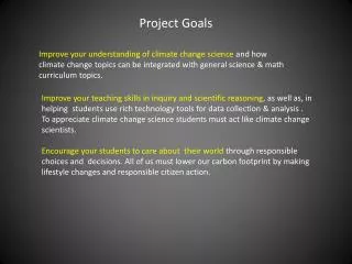
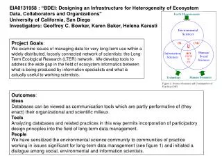
Exploring Landscape Planning Alternatives South Fork McKenzie Watershed Willamette National Forest Allison Reger, Forest Analyst Jane Kertis, Forest Ecologist Lisa Helmig, Forest Silviculturist. Project Goals. Develop a seral distribution in a 5 th field watershed.

E N D
Exploring Landscape Planning AlternativesSouth Fork McKenzie WatershedWillamette National ForestAllison Reger, Forest AnalystJane Kertis, Forest EcologistLisa Helmig, Forest Silviculturist
Project Goals • Develop a seral distribution in a 5th field watershed. • Demonstrate a process to evaluate and compare different alternatives over time and space. WHY? • Spatially communicate alternative scenarios. • Provide rationale for vegetation management prescriptions.
Project Questions • What is the seral distribution based on a historical reference condition - no fire suppression? • What is the current condition related to fire and seral stages? • What is the trend over time? • Can we maintain a range of seral conditions within the historical range in the watershed?
Analysis Models Spatial Non-Spatial
Giant trees Closed canopy Multi-layered Path A “State”is the compositional and structural characteristics of vegetation A “transition”is the driver that directs the direction and speed a state proceeds. Common drivers are natural disturbance, management or succession. Stand replacing wildfire
ST-STIM A state and transition “simulation” model which allows you to project changes in vegetation through time. Because it is spatially explicit, the location of vegetation “states” within a landscape are incorporated into the model so the effect of vegetation changes over time can be examined. Wildfire Imprint of early seral resulting from wildfire
Analysis Process Step 1: Develop scenarios Step 2: Develop desired future condition range Step 3: Summarize current conditions Step 4: Setting management scenario Step 5: Compare results
#1 DEVELOP SCENARIOS What is the current condition and trends over time related to historical fire regimes, current fire regimes and how would active management play a role in developing a seral distribution within the historical range of the watershed ?
#1 DEVELOP SCENARIOS… another way of considering the scenarios What is the current condition and trends over time related to historical fire regimes, current fire regimes and how would active management play a role in developing a seral distribution within the historical range of the watershed ? Management No Management
#2DEVELOP DESIRED FUTURE CONDTION Characterized data using LANDFIRE Rapid Assessment Vegetation Models to determine potential vegetation type (PVT). Developed a crosswalk for the PVT to the PATH models. Develop a desired future condition “Range”
EARLY SERAL RANGE LANDFIRE DESCRIPTION
LATE SERAL RANGE LANDFIRE DESCRIPTION
#3 SUMMARIZE CONDITIONS
#4 SETTING THE MANAGEMENT SCENARIO • LSR, Matrix and AMA allocations used to actively manage early and late seral objectives. • Developed a crosswalk of candidate and target states from which to create or maintain early and late seral classes. • Identified a list of management actions (PCT, Thinning, Regeneration, Fire). • Developed a rate based on assumptions from observing earlier runs and evaluating what the non-managed landscape would produce.
What states currently provide early seral and what states provide the opportunity to create early seral? TARGET STATE CANDIDATE STATES
#5 COMPARING RESULTS • Key differences • Key similarities • What level of active management achieved our goal – if it could be achieved at all?
Comparing results…. Watershed early seral range - 6-18% What will natural processes produce? Compare to the number of acres typically managed each decade on the McKenzie River Ranger District – Approx. 5,500
Tracking Tool…. Acres 160 10 100 Year
COMPARING RESULTS Historical fire regime Current fire regime Active Management for Early and Late Seral
#5 COMPARING SPATIAL RESULTS Year20 Active Management Without fire suppression With fire suppression
#5 COMPARING SPATIAL RESULTS Year50 Active Management Without fire suppression With fire suppression
#5 COMPARING SPATIAL RESULTS Year100 Active Management No fire suppression With fire suppression