Download
1 / 29
290 likes | 414 Views
NAPP Photo Five Pockets near Dubois. Google Earth. Geometric Corrections. Rectification and Registration. What is Geometric Correction?. Any process that changes the spatial characteristics of pixels. Pixel coordinates Pixel relationship with other pixels Pixel size

E N D
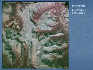
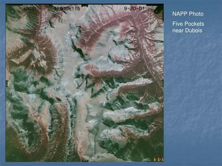
NAPP Photo Five Pockets near Dubois
Geometric Corrections Rectification and Registration
What is Geometric Correction? • Any process that changes the spatial characteristics of pixels. • Pixel coordinates • Pixel relationship with other pixels • Pixel size • Geometric correction also can change the digital numberof pixels (resampling)
Why Geometric Correction? • To allow an image to overlay a map • To eliminate distortion caused by terrain, instrument wobble, earth curvature, etc. • To change the spatial resolution of an image • To change the map projection used to display an image
Two basic techniques for fitting images to maps • Use Ground Control Points (GCPs) to assign real-world coordinates to an image (rectification). • Create links between two images or between the image and a digital map to align them with one another (registration) Both techniques are based on same concept.
Rectification Using GCPs • Object: To match pixel locations in the image to their corresponding locations on the earth • Method: • Assign real-world coordinates to known locations in the image (GCPs) • Create a mathematical “model” to fit the real-world coordinates to the image coordinates • “Warp” the image to fit the model.
Image Coordinate Frame (row/column) Real World Coordinate Frame (e.g., UTM)
Ground Control Points (GCPs) • Road intersections, river bends, distinct natural features, etc. • GCPs should be spread across image • Requires some minimum number of GCPs depending on the type of transformation(model) you use • More usually better than fewer! • Some say that it is better to have clusters of GCPs spread across image
Google Earth – Seminoe Reservoir (Wyoming). Where would you locate GCPs?
How is image registration different? • Instead of finding GCPs from a map, you link the same place on two or more images • Can be used to georeference an unreferenced image using a referenced image • Can be used to allow two images to perfectly line up with one another (e.g. images from the same place taken on different dates) even if they aren’t georeferenced
Two main steps necessary to fit an image to a map • Transformation: Use a mathematical equation to transform all image GCP coordinates to best match the real world GCP coordinates. • Resampling: Assign new DNs to the pixels once they have been moved to their new positions.
Mathematical Transformations Real World Coordinates Points = GCPs; Line = best linear (1st order) fit Image Coordinates
Mathematical Transformations • 1st Order • Requires minimum of 3 GCPs • Use for small, flat areas • 2nd Order • Requires minimum of 6 GCPs • Use for larger area where earth curvature is a factor • Use where there is moderate terrain • Use with aircraft data where roll, pitch, yaw are present
Mathematical Transformations (cont.) • 3rd Order • Requires minimum of 10 GCPs • Very rugged terrain • Typically want at least 3x the minimum number of GCPs
Image Transformation (warping) Raw Image (No spatial relationship to location on earth) Transformed Image (Matches real-world coordinates; Oriented to north, etc.)
Image Resampling • Once an image is warped, how do you assign DNs to the “new” pixels?
Resampling Techniques • Nearest Neighbor • Assigns the value of the nearest pixel to the new pixel location • Bilinear • Assigns the average value of the 4 nearest pixels to the new pixel location • Cubic Convolution • Assigns the average value of the 16 nearest pixels to the new pixel location
To maintain image radiometry (DNs) for spectral analysis ALWAYS USE NEAREST NEIGHBOR RESAMPLING! • If your purpose is to produce an image for presentation, bilinear or cubic might work better (can be more visually pleasing). • Remember that EVERY TIME you resample an image for any reason you are altering the original data!
Changing Image Spatial Resolution (A type of Resampling) • Two choices • Increase the resolution (artificially make pixels smaller) • Just assign the DN from the original pixel to the smaller pixels that fall inside it • Decrease the resolution (artificially make pixels larger) • Combine the DNs from the original pixels in some way (e.g. average them) to assign a new DN to the bigger pixel
Changing Map Projections • Map projections are mathematical schemes for depicting part of thespherical earth on a flat map or image • Every time you change from one map projection to another you transform and resample (and change the DNs!).
Geometric Correction -- Summary • Essential for almost all remote sensing projects • Critical for combining imagery and GIS • Essential for obtaining spatially accurate products—requires considerable care • Often done for us “at the factory,” but sometimes not, especially for aerial imagery (air photos, etc.)