Download
1 / 41
410 likes | 412 Views
This presentation discusses the review of height systems, geoid modeling, the GEOID99 model, and future directions in the field. It covers topics such as gravity measurements, digital elevation models, and the computation of geoid undulations using the Stokes Integral and the G99SSS method. It also highlights the comparison of GEOID99 with GEOID96 and the accuracy of GPS-derived orthometric heights.

E N D
Gravity and the Geoid at NGS Dru A. Smith National Geodetic Survey Presented at the 2000 Geodetic Advisor Convocation Silver Spring, MD April 11, 2000
Topics of Discussion • Review of height systems • Geoid modeling • GEOID99 • Future Directions
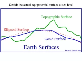
Review of Height Systems • (Helmert) Orthometric Heights • Ellipsoid Heights • Geoid undulations • NAD 83 & NAVD 88 • Mean Sea Level
Geoid Modeling • Data Sets • Methodology
Data Contributions • “Short Wavelength” (local) • Digital Elevation Models • “Medium Wavelength” (regional) • Surface Gravity Measurements • “Long Wavelength” (global) • Geopotential Model (EGM96)
Need: Gravity Measurements • Terrestrial • Ship-borne • Altimetrically-derived
Need: Digital Elevation Models • TOPO30 (30 arcsecond) for CONUS • GTOPO30 (30 arc second) for Canada • NGSDEM99 (1 arc second) for PNW
Step 1: Grid Bouguer Anomalies • Gravity measurements • DEM for Bouguer plate • DEM for Terrain Corrections
Step 3: Residual Free-air anomalies • Begin with Bouguer • Restore Bouguer plate • Remove EGM96
Step 4: The Stokes Integral • Input: residual free-air anomalies • Output: residual co-geoid undulations • 1-D FFT method
Step 6: G99SSS • Begin with residual co-geoid undulations • Add EGM96 • Add Indirect Effect • G99SSS is • GEOCENTRIC and • GRAVIMETRIC
Need: GPS on Benchmarks • NAD 83 ellipsoid heights • NAVD 88 Helmert orthometric Heights
Step 7: Conversion Surface Use Least Squares Collocation to combine: ITRF96 / NAD 83 transformation NAVD 88 bias (-52 cm) Tilt (0.15 ppm, 327 azimuth) Local GPS/Leveling/Geoid misfit G99SSS - Conversion Surface = GEOID99
GEOID99 • Comparison to GEOID96 • GPS-derived orthometric heights • Accuracy
2’x2’ North: 54 DEM: TOPO30 2951 GPS/BMs -31 cm NAVD 88 bias 5.5 cm RMS wrt GPS/BMs 1’x1’ North: 58 DEM: TOPO30 + NGSDEM99 6169 GPS/BMs -52 cm NAVD 88 bias 4.6 cm RMS wrt GPS/BMs GEOID96 vs GEOID99
GPS-derived Orthometric heights • Local accuracy is difficult to gauge • Few GPSBMs near each other • Depends on: • Quality of GPS • “Simplicity” of local geoid • Method of adjustment
Future Directions • Gravimetric • Improved gravimetric theory • GRACE/CHAMP • 1 arcsecond DEM over USA • Hybrid Geoid • 1 cm (1 s) GPS heights • Leveling near CORS
Summary • Gravity coverage is adequate to exceptional • 1 arc second DEM needed for all USA territories • GEOID99 improved on the success of GEOID96 • GPS derived orthometric heights at the <1 to 8 cm level
ON-LINE NGS GEOID RESOURCES • Official NGS Geoid Page: • http://www.ngs.noaa.gov/GEOID • Links to all geoid models • Links to all geoid papers from NGS • Lots of useful geoid information • Slideshows like this one (coming soon)