Download
1 / 22
230 likes | 432 Views
Coordinate Systems, Datums and Map Projections D’Arcangelis 11/9/09. Hmmm…. Every map user and maker should have a basic understanding of projections, no matter how much computers seem to have automated the process. Why is this important?. Creating spatial data (collecting GPS data)

E N D
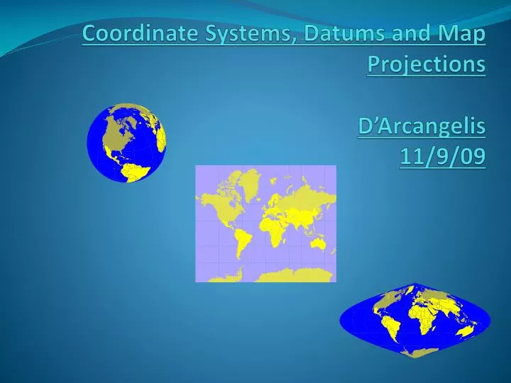
Coordinate Systems, Datums and Map ProjectionsD’Arcangelis11/9/09
Hmmm… Every map user and maker should have a basic understanding of projections, no matter how much computers seem to have automated the process.
Why is this important? • Creating spatial data (collecting GPS data) • Import into GIS and overlay with other layers • Acquiring spatial data from other sources • Display your GPS data using maps
Coordinate Systems • There are 2 types of coordinate systems: • Geographic Coordinate Systems • Projected Coordinate Systems
Geographic Coordinate System • A reference system using latitude and longitude to define the location of points on the surface of a sphere or spheroid • decimal degrees (DD) -92.5 • degrees/minutes/seconds (DMS) 92° 30’ 00” W
Geographic Coordinate System - Earth is not a sphere - Poles are flattened - Bulges at equator Earth is a spheroid……or ellipsoid
Geographic Coordinate System • Spheroid approximates the shape of the earth • Model of the earth • Essentially when surveyors get together and all agree to be wrong • Also called an “ellipsoid”
Geographic Coordinate System • A datum defines the position of the spheroid relative to the center of the earth • Origin and orientation of latitude and longitude lines are determined by the datum • Hundreds of datums customized for different parts of the world
Common Datums used in U.S. • North American Datum 1927 (NAD27) • Uses the Clarke 1866 spheroid • Reference point is located at Meades Ranch, Kansas • Based on ground survey inrmation in the 1800’s • North American Datum 1983 (NAD83) • Uses GRS80 (Geodetic Reference System) spheroid • Ellipsoid model from geocentric perspective • Based on ground surveys and satellite information • WGS 1984 • Most recently developed datum/ framework for measurements worldwide • Earth centered, or geocentric, perspective • This is the datum used by all GPS satellites • Nearly identical to NAD83…therefore NAD83 is compatible with data collected in GPS using WGS84!
Transforming between datums • Several methods available for transforming between NAD27 and NAD83 • Standard and most accurate is NADCON • Available in ArcView 8.x (ArcToolbox) • Many GPS devices transform using less accurate transformations • If you your GIS data is in NAD27, you should considering collecting in NAD83/WGS84 and transform your coordinates using ArcToolbox • See “Appendix A” in TEC7132 course book on how to perform datum transformation using ArcToolbox
Geographic Coordinate System • Universal Coordinate System (lat/long) • Lat/long is good for locating positions on surface of a globe • Lat/long is not efficient for measuring distances and areas! • Latitude and longitude are not uniform units of measure • One degree of longitude at equator = 111.321 km (Clarke 1866 spheroid) • One degree of longitude at 60° latitude = 55.802 km (Clarke 1866 spheroid)
Projected Coordinate Systems • A map projection is the systematic transformation of locations on the earth (latitude/longitude) to planar coordinates • The basis for this transformation is the geographic coordinate system (which references a datum) • Map projections are designed for specific purposes
This process of flattening the earth will cause distortions in one or more of the following spatial properties: • Shape • Conformal map projections preserve shape • Area • Equal area map projections preserve area • Distance/Scale • Equidistant map projections preserve distance • Direction/Angle • Azimuthal map projections preserve true direction
Universal Transverse Mercator (UTM) • Developed by military • Grid system • Earth divided into 60 zones • Great for small areas • minimal map distortion • distortion greater at edge of zones • Most common map projection used by NWRs
Universal Transverse Mercator- Grid Zone 1 Equator International Date Line - 180 o Zone 18
State Plane Coordinate System • To support high-accuracy applications, all US states have adopted their own specialized coordinate systems: State Plane Coordinates. For example, Texas has five zones based on the Lambert Conformal Conic projection, while Hawaii has five zones based on Transverse Mercator projection. http://www.pipeline.com/~rking/spc.htm
When GPS points don’t align with GIS Data Most likely a projection issue if: • There are huge errors…data points do not overlay • Features could be displayed in wrong state or hemisphere!
When GPS points don’t align with GIS Data Possibly a datum issue if: • GPS data overlays with GIS data, but off by several hundred feet • Differences between NAD27 and NAD83 can be as much as 500 feet • This creates problems when doing analysis
Conclusion • All maps are centered on a point or plane • Different projections cause maps to display spatial data differently • Careful thought toward map projection must be made in order to display data correctly