Download
1 / 50
500 likes | 577 Views
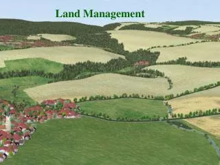
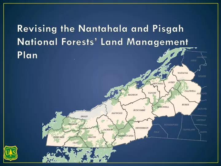
Revising the Nantahala and Pisgah National Forests’ Land Management Plan. Phase 1 – The Assessment of the Existing Condition of the Forests. Phase 2 – Develop the Revised Plan. Nantahala and Pisgah National Forests. Cities and Counties have land use plans – so do national forests

E N D
Revising the Nantahala and Pisgah National Forests’ Land Management Plan
Phase 1 – The Assessment of the Existing Condition of the Forests Phase 2 – Develop the Revised Plan
Nantahala and Pisgah National Forests • Cities and Counties have land use plans – so do national forests • Cities and counties may have residential areas, commercial areas, mixed-use areas – national forests ALSO have areas for different mixes of uses
Land Management Plan in place now dates from 1987 - Some major updates in 1994 - Minor updates since 1994 Time to take a fresh look . . .
Topics for TODAY: -- The inventory process for potential additions to wilderness -- Establishing needs-based criteria for considering other specially designated areas -- Commenting on the new scenery inventory
What Happened in 2013 – the Assessment Phase • February-March 2013 – • 6 public meetings to get ideas for the Assessment • May 2013 – • 2 public meetings to discuss high interest topics: • Wildlife habitats, and especially the lack of young forest (a.k.a. early successional, ESH, previously called 0-10 year old forest ) • Recreation and access • Designated Areas – what should be designated and what should NOT be designated • November-December 2013 – • 6 public meetings to hear ideas about how the current plan needs to change.
What’s happening in 2014 – the Plan Development Phase • What do we want these national forests to be like in the future? • How much and what kinds of management will need to happen for us to get there? • What sideboards or limitations on activities are necessary? • Which portions of the national forests are suitable for various mixes of the multiple uses?
National Forests are managed for Multiple Use and Sustained Yield Outdoor Recreation Timber Water Wilderness Wildlife and Fish Threatened and Endangered Species Special Interest Areas Experimental Forests Research Natural Areas Wild and Scenic Rivers
National Forests are managed for Multiple Use and Sustained Yield Outdoor Recreation Timber Water Wilderness Wildlife and Fish Threatened and Endangered Species Special Interest Areas Experimental Forests Research Natural Areas Wild and Scenic Rivers
Inventory of Potential Additions to Wilderness WHY ? It is required as a part of the process for revising the land management plan
FEDERAL REGULATION: As part of the plan development process . . . . (v) Identify and evaluate lands that may be suitable for inclusion in the National Wilderness Preservation System and determine whether to recommend any such lands for wilderness designation.
Objectives for this morning: • Share the range of perspectives about wilderness • Share the purpose of the inventory • Share and discuss the inventory process and identity concerns and potential solutions • Establish a path forward to a final inventory most people can live with
Ideas and comments collected in November and December 2013 . . . including comments about wilderness . . . Sorting Comments
What have we heard from participants so far? Everything is Wilderness Keep the Same Amount Increase Wilderness Reduce Wilderness No Wilderness
What is wilderness? “where the earth and its community of life are untrammeled by man, where man himself is a visitor who does not remain…an area of undeveloped Federal land retaining its primeval character and influence, without permanent improvements or human habitation, which is protected and managed so as to preserve its natural conditions and which (1) generally appears to have been affected primarily by the forces of nature, with the imprint of man's work substantially unnoticeable; (2) has outstanding opportunities for solitude or a primitive and unconfined type of recreation;….”
Existing wilderness areas of the Nantahala and Pisgah National Forests • Shining Rock • Middle Prong • Linville Gorge • Southern Nantahala • Ellicott Rock • Joyce Kilmer-Slick Rock • 66,550 acres • 6.4% of Nantahala and Pisgah NFs
Existing wilderness study areas of the Nantahala and Pisgah National Forests • Harper Creek (recommended) • Lost Cove (recommended) • Craggy Mountain (recommended) • Snowbird (not recommended) • Overflow (not recommended) • 26,920 acres • 2.6% of Nantahala and Pisgah NFs
Potential Additions to Wilderness We are Here 1. Inventory – the starting point 2. Evaluate – for wilderness characteristics 3. Determine which areas to include in the draft plan (and analyze in the DEIS) 4. Determine whether to recommend for wilderness
Potential Additions to Wilderness We are Here 1. Inventory – 2. Evaluate – for wilderness characteristics (WC) 3. Determine which areas to include in the draft plan (and analyze in the DEIS) 4. Determine whether to recommend for wilderness
Potential Additions to Wilderness 1. Inventory 2. Evaluate – for wilderness characteristics (WC) More WC Less WC 3. Determine which areas to consider for the revised plan (and analyze in the DEIS) 4. Determine whether to recommend for wilderness
Wilderness Characteristics: • Appears primarily affected by the forces of nature (naturalness) • Outstanding opportunities for solitude and a primitive or unconfined type of recreation. • Presence of ecological, geological, or other features of scientific, educational, scenic, or historical value. • Can it be managed to preserve wilderness character • Shape and configuration • Presence of non-Federal land • Management of adjacent land
Potential Additions to Wilderness 1. Inventory 2. Evaluate – for wilderness characteristics (WC) 3. Determine which areas to consider for the revised plan (and analyze in the DEIS) 4. Determine whether to recommend for wilderness ??
If an area in the inventory isn’t recommended as an addition to wilderness, what happens post-revision? Inclusion in the inventory of potential additions to wilderness IS NOT a designation that conveys or requires a particular kind of management. - Propose directive FS 1909.12, Version 02/14/2013
Potential Additions to Wilderness What has been recommended recently in other southern national forest revisions? • Uwharrie National Forest (2012) – 2 parcels adjacent to existing wilderness totaling 7.1 acres • Ouachita National Forest (2005) – 3 parcels adjacent to existing wilderness totaling 1,793 acres • George Washington DRAFT revised plan (2014) – 4 parcels totaling 62,670 acres (three adjacent to existing wilderness plus one stand-alone area) • National Forests in Mississippi DRAFT revised plan (2014) – no areas recommended for wilderness
Inventory Process – what to look for IDEALLY– a large block of forest land with little or no evidence of human development or human management other than trails, with only primitive, out-of-use roads (Level 1 roads), or with no roads.
Inventory Process – what to consider • The inventory is intended to be reasonably broad and inclusive • SO WHERE DO YOU START LOOKING? • Start with information from the assessment, including information about designated areas (e.g.Inventoried Roadless Areas) and transportation infrastructure. There are over 150,000 acres of IRA. • Also – “areas that have been proposed for consideration as recommended wilderness through public involvement during the assessment or previous forest planning processes.”
What are Inventoried Roadless Areas? • Established by Federal Regulation in early 2001 • There are 33 IRAs across Nantahala and Pisgah National Forests, totaling over 150,000 acres • IRA status can only be changed through another federal regulation or by congressional action. However, dual designation as IRA and recommended wilderness is possible.
What are Inventoried Roadless Areas? • In general, road construction, road reconstruction, is NOT permitted in IRAs. Road maintenance is permitted. • Timber production is NOT permitted. However some tree cutting incidental to permitted management activities (such as prescribed burning) IS permitted. • Motorized equipment (such as chainsaws) ARE allowed in IRAs and mechanical transport (such as mountain bikes) may be allowed.
Inventoried Roadless Areas (IRAs) Other areas recommended during the assessment often were in part coincident with IRAs
Inventory Process – what to consider • MUST meet one of the following: • The area contains 5,000 acres or more. • Less than 5,000 acres but practical to preserve in an unimpaired condition, such as a self-contained island or canyon. • Areas contiguous with existing wilderness, primitive areas, administratively recommended wilderness, or wilderness inventories of Federal ownership, regardless of size.
Inventory Process – what NOT to consider • Road Improvement Criteria – Exclude areas that contain: • Roads that are open any part of the year or that are maintained by mechanical means • Roads with easements • Roads identified for continued public access and use • Roads that have cumulatively degraded wilderness character
Inventory Process – what NOT to consider Other exclusions: Areas where vegetation treatments are substantially noticeable Areas of mining that are substantially noticeable Developed recreation sites Permanent linear rights-of-way (e.g. a cleared power line, railroads) Substantially noticeable watershed treatment areas
STEP 1: Make a map with existing wilderness, wilderness study areas, inventoried roadless areas, other areas recommended by the public, roads (other than level 1), wildlife openings, recent timber regeneration harvest areas, and property boundaries. STEP 2: Revision team members and district staff using Forest Service data, satellite imagery, and personal knowledge, consider each area.
STEP 3: Eliminate areas clearly less than 5,000 acres unless they share a border with an existing wilderness or recommended wilderness study area. STEP 4: Exclude portions of areas that contain excludable improvements; refer to items a) through d) of process paper STEP 5: Draw the lines on the maps
STEP 6: If the hand drawn area still appears to meets the minimum size, Digitize the area into the GIS database and calculate the approximate acres using GIS technology STEP 7: Produce maps of each district with the VERSION 1 Inventory displayed
For each Area Considered: Does it meet the SIZE criteria? Does it contain areas of roads to exclude? Does it contain areas of substantially noticeable vegetation management? If so, exclude that portion of the area. Are there easements or rights-of-way to avoid? If so, exclude that portion of the area.
For each Area Considered: Are there any other substantially noticeable development? If so, exclude that portion of the area. Are there portions of the area less than ½ mile wide? If so, exclude those portions of the area. Does it STILL meet the size criteria?
What we debated: Where do we draw the preliminary boundaries? What do the words “substantially noticeable” mean? What portion of an area do we exclude when there are multiple factors present? What distance should the boundary back away from an excluded road? How do we negotiate the “reasonably broad and inclusive” direction with what makes sense from a manageability perspective?
MAP VIEW • A portion of Appalachian and Grandfather Ranger Districts • Just northeast of Black Mountain • 5 Inventoried Roadless Areas Woods Mountain
Wilderness Society’s proposed Mountain Treasure Area – Black Mountains • An area of consideration in the initial inventory. Mt. Mitchell State Park
There is a cleared right-of-way that divides the area • Bearwallow – 4,115 acres. Does not meet the size criteria for the inventory • Black Mountains area DOES meet inventory criteria Black Mountains 12,426 Bear Wallow
Jarrett Creek Inventoried Roadless Area • The area of a road is excluded • The area of recent vegetation management is excluded
Our Preliminary INVENTORY Results: • Areas considered: 57 • After criteria applied: 34 • Stand alone areas: 20 (151,555) • Areas adjacent to Wilderness or Recommended WSA: 14 (46,811) TOTAL acres 198,366 +/- 19% of Nantahala and Pisgah
What happens to the inventory areas that aren’t recommended for wilderness? That Depends: If it’s an IRA (Inventoried Roadless Area) there are still regulations in place that limit some of our forest management options. That doesn’t change. If it isn’t an IRA, the area will be considered for multiple use management just like the rest of the national forests. There is no residual impact just from being in the inventory of potential additions to wilderness.
What we’re asking you to discuss today: Recognizing that everyone in this room would likely draw the boundaries a bit differently, even using the same rules we used, to what degree can you live with the process we’ve described to identify the inventory areas ? Part 1: Discussion Questions for each table. Part 2: Take a look at each of the six maps. Bring up any specific reaction to a specific area.
Everything is Wilderness Keep the Same Amount Increase Wilderness Reduce Wilderness No Wilderness