Download

1 / 29
290 likes | 296 Views
This breakout session will focus on the scientific questions and issues addressed by planned space-based observations, specifically related to vegetation structure measurement missions such as ICESat-II and DESDynI. Participants will discuss priority science uses, preparation needed for these measurements, and any major issues to be resolved.

E N D
Breakout Session 1 • 5. Science Enabled by New Measurements of Vegetation Structure (ICESat-II, DESDynI, etc.) Chairs: Hank Shugart, Jon Ranson Room: Auditorium • Purpose: These discussions will: • allow workshop participants to consider the scientific questions and issues that will be addressed by planned space-based observations. • be an opportunity to learn about what the missions recommended in the NRC's Decadal Survey will enable through their measurements. • These sessions will: • provide background on mission specifications and planning, but the focus is to be on the science enabled by the measurements. • provide an opportunity to identify opportunities and recommend new studies as well as to raise issues or concerns to be addressed by the Focus Area
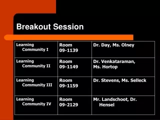
5. Science Enabled by New Measurements of Vegetation Structure (ICESat-II, DESDynI, etc.) Chairs: Hank Shugart, Jon Ranson Room: Auditorium • Agenda • 2:30-2:45 H Shugart The anticipated scientific uses and payoffs of the planned new measurement/mission Shugart • 2:45-3:00 J. Ranson The new mission (or missions) and what was learned in any relevant NASA mission concept studies Ranson (10-15 min.) • 3:00- 3:05 – Reorganize into two similar sized breakout groups • Shugart – Auditorium • Ranson – 0109 • 3:05 – 4:00pm Group discussion on the following questions: • What are the priority science uses of the new measurement(s)? (participants may choose to confirm/validate existing science questions/applications and/or may identify new uses) • What do we need to do scientifically to use these new measurements and/or to get ready for the mission? • Are there any major issues to be resolved before this science is enabled, and if so, what are they and what needs to be done? • 4:00 Break
DESDynI, ICESat 2, LiST: The new missions and what was learned in NASA’s mission concept studies Jon Ranson NASA GSFC Biospheric Sciences Branch Vegetation Structure Workshop – Charlottesville, VA Mar 3-5, 2008
The Carbon Sheet is shrinking Millennium Ecosystem Assessment Synthesis Report (2005) Carbon Cycle and Ecosystems Science Question How are the Earth's carbon cycle and ecosystems changing, and what are the consequences for the Earth's carbon budget, ecosystem sustainability, and biodiversity?** The question requires measurements of three-dimensional vegetation structure to estimate: • Carbon in Aboveground Vegetation • Ecosystem Structure - Indicators of ecosystem function habitat and biodiversity Carbon in the aboveground biomass of forests represents about 85% of the total carbon in the Earth’s aboveground biomass. Olson et al. 1983 **Earth Science Enterprise Strategy, October 2003 Science Mission Directorate Draft Science Plan, 2006
Carbon Cycle and Ecosystems Constellation • PAST AND PRESENT • LANDSAT (1972-2008) Area disturbed & recovery, age, veg type • AVHRR (1981-2008) Recovery rate, annual variation (Fpar, LAI) • Terra/Aqua (2000-2008) Recovery rate, annual variation (Fpar, LAI) • ICESAT (2003-2008) Vegetation structure • Shuttle - SRTM (2000) Topography, Vegetation structure • Shuttle - Sir C (1994) Disturbance, Veg type, biomass • ESA MISSIONS • SPOT, MERIS Area disturbed & recovery, age, veg type • SCHIMACHY CO2 • JAXA MISSIONS (1990s,2000s) Disturbance, veg type • JERS-1 and ALOS - PALSAR • CHINA-BRAZIL (1993-2008) CBRS Disturbance, veg type, recovery • INDIA (1988-2008) IRS Disturbance, veg type, recovery • FUTURE • NPP, VIIRS (2012) EOS, MODIS Follow on • OCO (2008) CO2 • ICESat 2 (2010 - 2013) Veg Structure, biomass • DESDynI (2010 – 2013?) Veg Structure, biomass,disturbance & recovery • BIOMASS (ESA 2015?)) Biomass, Veg Structure • LiST(2016?) Vegetation structure, biomass • HYSPERI Vegetation type and function
Ecosystem changes are reflected strongly in the vertical height and density distribution of vegetation and its horizontal heterogeneity Disturbance event Mature Forest Older Regrowth Carbon Sink Height Young Regrowth Forest opening Time More Biomass (figure from J. Drake) • Both human-induced and natural disturbance are major driving forces that determine the transition of forest stands, landscapes, and regions from carbon sink to source and back. Forests tend to be patchy due to natural and human disturbance. In this radar image from Canada there is evidence of fires ( dark areas at top) and logging (e.g.,black features in center) Disturbance form fire, insects, disease, logging, storms
THE ROAD TO A VEGETATION STRUCTURE MISSION • Spadework • Airborne radar and lidar, SIR-C, ICESat, VCL, 2003 VEG Structure Workshop • Decadal White Paper Submissions ( BIOMM, BIOMM-L) • Preliminary VEG-3D Decadal Survey And ICESat II MISSION Studies By NASA (GSFC and JPL with HQ) • Decadal Survey Ecosystem Panel • Deliberations During Panel Sessions • Tradeoffs • Solid Earth Panel • Ice Panel • Ecosystems Panel • ICESat II, DESDynI, Vegetation Structure Workshops • This Joint Workshop helps provides a way forward
Mission Science Objectives • Develop globally consistent and spatially resolved estimates of aboveground biomass and carbon stocks. • Make globally consistent and spatially resolved measurements of vegetation vertical structure to understand changes and trends in terrestrial ecosystems and their functioning as carbon sources and sinks. • Characterize and quantify the three-dimensional structural response to disturbance. • Quantify changes in terrestrial carbon sources and sinks resulting from disturbance and recovery. • Characterize habitat structure for biodiversity assessments.
VEG3D & Biomass Mission Measurement Requirements: • Contiguous Global Biomass Assessment (Objective 1) • Spatial resolution: 100 m2 (1 hectare) • Initial assessment following first year of mission • 1 ha Precision of global biomass estimates increasing after five years to +10 Mg carbon (or 20%, whichever is greater), but no greater than +50 Mg. • Measurement of Changes of Vegetation Biomass from Disturbance & Recovery (Objective 2) • Mapping all types of disturbance (anthropogenic and natural) • Spatial Resolution: ≤ 100 m • Measuring biomass changes at scale of 1 km with precision of 2-4 Mg/ha/year • Revisit time: monthly to seasonal for disturbance (less for recovery)
VEG3D & Biomass Mission Measurement Requirements: • Measurement of changes of forest structure from disturbance and recovery (Objective 3) • Sampling of vegetation height, volume, vertical profile, canopy texture, biomass • Spatial Resolution: ≤ 25 m • Minimum height precision of + 5 m (desired at + 2 m), +10% biomass change • Revisit time: Annual to Seasonal • Measurement of vegetation structure for biodiversity and habitat assessment (Objective 4) • Spatial Resolution: ~ 25 m • Biomass, vertical structure and diversity (max and mean height, profile), crown closure, canopy and surface roughness (STDV of height), patch size, edge detection • Minimum height precision of + 2 m (desired at + 1 m), +15% biomass, canopy roughness precision of +20% (desired +10%) • Revisit time: Annual to Seasonal
Science RationaleInstrument Rationale The variability of 3D structure in a forest canopy is apparent in this transect of airborne multi-beam lidar profiles. It is this variability that limits our understanding of the global carbon storage in vegetation and it is these type of measurements that will reduce uncertainties Global measurements like these from space are needed to answer the science question
Science RationaleInstrument Rationale SAR illuminates the vegetation with microwave energy at an angle that interacts with vegetation structure and the ground and senses the entire canopy volume and woody density. Such measurements can be directly related to aboveground biomass for forests of low to medium biomass. SAR measurements can be performed in most weather conditions and provide the capability of mapping the vegetation cover and changes due to natural and human-induced disturbances frequently.
Vegetation 3D Structure, Biomass and DisturbanceConcept Study • Recognition of critical importance of the 3rd dimension for measurements of vegetation • Directed by NASA HQ to study LIDAR and SAR together • Study led by GSFC with direct participation of JPL and supported by the Vegetation Structure Science Working Group
DESDynI DESDynI
DESDynI Concept • DESDynI is an L-band InSAR and multibeam LIDAR mission for improving our understanding of hazards, ice sheet dynamics, and ecosystems Polarimetric SAR and Finite Baseline InSAR Repeat Pass InSAR Multibeam LIDAR single baseline Vegetation structure Ground or ice motion A. Donnellan, NASA JPL)
VEG3D & Biomass Mission Instrument Functional Requirements: • Full Waveform Multi-beam Lidar • Pulsed lidar (1064 nanometer) Link Margin/SNR:100:1 • Footprint spacing: ≤ 25 m • 3-5 beams (3-5 km separation), 35% duty cycle • Vertical sampling to resolve <1m range differences (~500 Msamp/s) • Geolocation accuracy: ~10 m horizontal, ~1m vertical • Beam Spacing: Tradeoff between sampling density and cross over density • (Sampling/Resampling strategy with resampled areas annually • and seasonally matched) • Lidar swaths 1-3 weeks from Radar Swath
VEG3D & Biomass Mission Instrument Functional Requirements: • Polarimetric Repeat Pass InSAR • L-band (1.26 GHz) Synthetic Aperture Radar, 15 MHz bandwidth • Quad Polarization (HH, HV, VH, VV) • Spatial Resolution: 25 m(4 looks), 100 m(> 50 looks) • Incidence Angle: 25-35 degrees • Repeat Cycle: Unknown because of temporal decorrelation (< 1 day) • Absolute Calibration: 1dB, Relative Calibration: 0.5 dB • Polarimetric InSAR: one baseline (more than one baseline desired) • Height Accuracy ~ 1-2 m
DESDynI Workshop Recommendations • Orbital repeat interval • 8 days is preferred by Solid Earth and Ice and would enable InSAR uses for vegetation structure • Longer repeats are preferred for ecosystem structure to acquire adequate lidar geographic coverage • Use of a slightly longer repeat with off-nadir lidar pointing might mitigate this issue, with orbits of 12-16 day repeat time • Orbital altitude • 800 km minimizes atmospheric orbit degradation for InSAR • 400 km altitude is optimal for lidar operation • Compromise altitude of 600 km is possible and would satisfy all scientific objectives • Interferometric operating baseline • Zero length is preferred for the Solid Earth and Ice science • Multiple nonzero baselines are preferred for ecosystem structure • This is probably resolvable with planned baselines of approximately 500-1000 m for some fraction of the mission to be determined
Ecosystem Structure Coverage DESDynI Workshop Recommendations Spacecraft configuration • Develop a better understanding of how non-nadir lidar pointing can be used to fill gaps and increase the spatial density of coverage for vegetation structure while maintaining the necessary accuracy • Examine deploying the InSAR and lidar on separate platforms – each in its optimal orbit • Look at possibility of integrating DESDynI lidar with ICESat-II Algorithm Development • Advance the development of algorithms for lidar-radar fusion and lidar-InSAR fusion to estimate canopy structure, dynamics and biomass • Analysis of the combination of lidar and radar data is reasonably understood at present, while the potential of lidar-InSAR techniques is high but not yet fully developed. • Both approaches require further development
ICESat-II ~2015
ICESat II • Single Beam Lidar, 70m footprints spaced 140 m apart • 94o inclination orbit to ensure polar coverage to >86 degrees • Repeat of ICESat tracks is required to fully utilize baseline of ICESat elevations and cross-track slope information. • 5-7 years of measurement duration to establish climatological significance • Combined with ICESat I to obtain >10 years of elevation change and sea ice thickness information • Sufficient continuous sampling for ice sheet and sea ice model development and validation • New Start Funding from NASA!
ICESat II - Key Discriminating Mission/Instrument Discriminators The primary mission consideration is continuousrepeat observations of ice for extended periods of time • Mission duration • Footprint size* • Footprint spacing • Pointing capability • Pointing knowledge • Orbit √ √ √ √ √= generally accepted and not being studied * For Ice, does not need to be determined prior to phase A
ICESAT II • Configured The Same As ICESat I, ICESat II: • Will make lidar measurements of vegetation canopies that can satisfy 10% of vegetation measurement requirements • Loses sensitivity in tropics where most needed due to high inclination non-sun synchronous orbit • Has +3-4 mheight and +50 Mg/ha biomass errors • HQ supported concept study showed it is feasible to fly a multibeam small footprint lidar along with the ICESat Lidar • Possibility to revisit concept study to consider Lidar with improved vegetation capabilites
ESA BIOMASS • The objective of the BIOMASS mission is to acquire global measurements of forest biomass to assess terrestrial carbon stocks and fluxes. Expected sensitivity of up to 100-150 Mg/Ha • The mission concept is envisaged as a spaceborne P-band synthetic aperture polarimetric radar operating at 435 MHz • One of six missions being developed with one to be selected in 2010 and flown by 2015 • Orbit: Sun-synchronous, local time ~0600 • Coverage: global, vegetated areas • Revisit time: 25 days • Polarisation: full polarimetry and/or • circular/dual polarisation • Data acquisition: single-pass/repeat-pass • polarimetric interferometry • Resolution: ≤50 x 50 m (≥4 looks) • Swath width: ≥100 km http://www.esa.int/esapub/bulletin/bulletin131/bul131d_bensi.pdf
JAXA ALOS PALSARPhased Array Type L-band Synthetic Aperture Radar • PALSARis an L-band SAR with 10 and 100 m resolutions that are capable of detailed, all-weather, day and night observations and repeat-pass interferometry. • Data since October 2006 Orbit Sun synchronous Altitude 691.65 km Recurrent period 46 days Inclination 98.16 degree
Concluding remarks • Excellent opportunity to exploit 3rd dimension of vegetation canopies: • close carbon budget • make ecosystem structure discoveries • Others? • DESDynI mission is Decadal Survey response to need for lidar and radar for carbon and ecosystems • Needs careful study to accommodate multidisciplinary science requirements • Carefully consider Decadal Survey options for our mission • Other missions can provide additional data useful but not sufficient alone for answering our science questions. • Consider ICESat as potential contributor to vegetation requirements • Partnering with ESA and JAXA?
DESDynI WS- Other Specific Recommendations • Mission configuration scenarios • Conduct studies to assess the options proposed to resolve/minimize the apparent incompatibilities among requirements for baselines, orbit, altitude and coverage • Develop a better understanding of how to compensate for non-nadir lidar pointing to fill gaps in coverage • Spacecraft configuration • Examine deploying the InSAR and lidar on separate platforms – each in its optimal orbit • Look at possibility of integrating DESDynI lidar with ICESat-II • Ecosystem structure coverage • Develop a better understanding of how non-nadir lidar pointing can be used to fill gaps and increase the spatial density of coverage for vegetation structure while maintaining the necessary accuracy • Algorithm development • Advance the development of algorithms for lidar-radar fusion and lidar-InSAR fusion to estimate canopy structure, dynamics and biomass • Analysis of the combination of lidar and radar data is reasonably understood at present, while the potential of lidar-InSAR techniques is high but not yet fully developed. Both approaches require further development • Advanced analysis • Develop and demonstrate the ability to derive vegetation height and estimate biomass from InSAR measurements across a range of the Earth’s biomes • Acquire new data to test and explore lidar-InSAR capabilities for vegetation structure and to be used in developing data fusion algorithms • Setting mission requirements • Formalize the specific scientific requirements necessary to move the mission to implementation