Download
1 / 23
230 likes | 364 Views
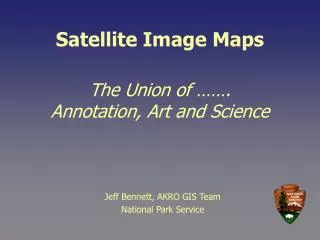
Satellite Image Maps. The Union of ……. Annotation, Art and Science. Jeff Bennett, AKRO GIS Team National Park Service. Satellite Image Map Project. Collaboration between AKRO I&M Landcover Mapping Program and GIS Team Vision of the map series - Wall art quality products

E N D
Satellite Image Maps The Union of …….Annotation, Art and Science Jeff Bennett, AKRO GIS Team National Park Service
Satellite Image Map Project • Collaboration between AKRO I&M Landcover Mapping Program and GIS Team • Vision of the map series - Wall art quality products - Park wide image mosaic - Park wide annotation GDB
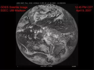
Satellite Image Map Project • Particularly important in Alaska due to lack of current base cartographic data • Primarily use TM7 Imagery • Maps have been completed for 7 of 16 Alaska NPS units
NPS Satellite Image Map Project Status March 2008
Raw Imagery Erdas IMAGINE Permanent Data Set Products Mosaic GeoTiff Draft Mosaic, Image Patches Area of Interest PDF Map ArcMap Annotation and Feature Source Data Image Map Annotation Printed Map Base Annotation Image Defects Repaired PDF Map Photoshop Software and Workflow
Erdas IMAGINE • Process raw imagery • Color balance images • Project images to Alaska Albers NAD83 • Build initial mosaic • Use AOI tool to patch areas of • Clouds • Snow • Bad data
ArcMap is Functional Core • Cartographic Tools • Annotation development • Base data • Imagery • Export areas for editing in Photoshop • Georeference edited image patches • Generate products
ArcMap Tiff Export Process • Maintain native cell size • Maintain projection • Export multiple raster’s to single Tiff • Editable in Photoshop • Can be import back into ArcMap
ArcMap Tiff Export Process • Issues Encountered • ArcMap doesn’t allow user to directly define export cell size • User can define Absolute Scale • User can define DPI of output • Imagery cell size in meters
ArcMap Tiff Export • Meters vs DPI Solution 0.0254 Meters per Inch • Basic Formula DPI = .0254 * x Absolute Scale = Cell size in Meters * x x = 500 or 1000 or 2000 etc.
ArcMap Tiff Export • Source imagery cells must be orthogonal to projection (Alaska Albers Equal Area NAD83) • Raw UTM imagery cells are orthogonal to path • If exporting from Data Frame View must not write “World File or Geo Tiff Tags” • More control of export area from Layout Frame • Exporting from Layout Frame, Data Frame border must be set to “None” • Creating View Bookmark for georeferencing patch
The Art of Terra Forming(Editing Tiffs in Photoshop) • The goal is natural looking imagery • Must understand natural processes and honor them while editing • The power of cloning, use it wisely • Visibility of cloning artifacts is scale related • Strait lines are not natural; scene edges • Organic is the Mantra
Editing Tiff’s in Photoshop • Mosaic Issues and Imagery Defects • Scene edges • Areas of high clouds • Orphan cloud shadows • Sediment plumes in water • Data dropouts and errors • Seasonal variation; snow, vegetation • No data areas; ocean
Shadow Mismatch IMAGINE Patch
Area of High Overcast Scene Edge
Truncated Cloud Shadow Scene Edge
Truncated Sediment Plumes Scene Edge No Data Area
ArcMap Tiff Patch Import • Add Tiff Patch to ArcMap • Add Georeferencing Toolbar • Must Georeference to Source Image • Zoom the saved Bookmark • Set Layer to Tiff Patch file • Fit to Display • Add Control Points to opposite corners • Choose one corner and refine Control Point to a 1:1 scale using the intersection of 4 pixels • May need to force redraw a scale nears 1:1
ArcMap Tiff Patch Import • Geoferencing Continued • Open Link Table and delete coarser Control Point as you refine location • Refine Control Point for other corner with same process • Add and refine Control Points for remaining corners • Verify fit by checking pixel intersections • Rectify Tiff Patch • Repeat process for additional patches and final flattened mosaic
Projection: Source: Scale: DPI: Patch Size: Alaska Albers NAD83 28.5m cell size 1:285,000 254 75 x 56 Kilometers Accuracy Assessment
Final Cartographic Details • Mosaic with patches • Add Hillshaded DEM • Adds detail to snow areas • Smooths image • Invert Hillshade Color Ramp • 92 % transparency • Annotation optimized for imagery • Matches current geography; Rivers, Glaciers • Contrasting color scheme, halos if needed • Buffer park boundary • Create ramped transparency
Final Products • PDF of final map • Select “Clip Output to Graphic Extents” • 300pdi • Base Annotation GDB • Normalized Image Map Anno for general cartographic use • Mosaic Geo Tiff • Image Map Annotation GDB