Download
1 / 49
490 likes | 496 Views
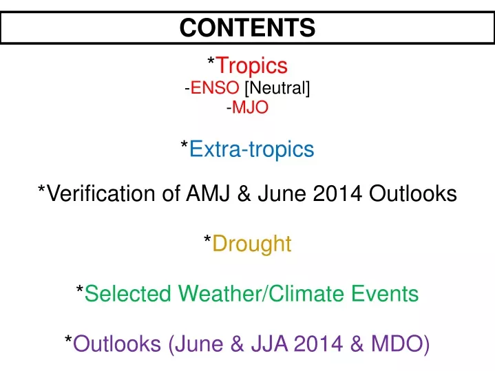
CONTENTS. * Tropics - ENSO [Neutral] - MJO * Extra-tropics *Verification of AMJ & June 2014 Outlooks * Drought * Selected Weather/Climate Events * Outlooks (June & JJA 2014 & MDO). I. The Tropics. The latest weekly SST departures are:. Niño 4. 0.3ºC. Niño 3.4. 0.4ºC. Niño 3.

E N D
CONTENTS *Tropics -ENSO [Neutral] -MJO *Extra-tropics *Verification of AMJ & June 2014 Outlooks *Drought *Selected Weather/Climate Events *Outlooks (June & JJA 2014 & MDO)
The latest weekly SST departures are: Niño 4 0.3ºC Niño 3.4 0.4ºC Niño 3 1.0ºC Niño 1+2 1.4ºC Niño Region SST Departures (oC) Recent Evolution
During the last four weeks, above-average equatorial SSTs were observed across the Pacific and near Indonesia. Global SST Departures (oC) During the Last Four Weeks
During the last four weeks, changes in equatorial SST anomalies were negative near the International Date Line and positive in small areas of the eastern Pacific. Change in Weekly SST Departures over the Last Four Weeks
Subsurface temperature anomalies increased during June, August, and in October 2013. From January - March 2014, temperature anomalies strongly increased. Since April 2014, the positive anomalies have weakened and are now near zero. Weekly Central & Eastern Pacific Upper-Ocean (0-300 m)Average Temperature Anomalies
Most recent pentad analysis Positive subsurface anomalies are evident near the surface (<100m) across most of the Pacific basin, while negative anomalies have strengthened in the central and east-central Pacific at depth. Sub-Surface Temperature Departures in the Equatorial Pacific
Updated: July 10 2014 The chance of El Niño is 70% during the Northern Hemisphere summer and reaches near 80% during the fall and winter. CPC/IRI Probabilistic ENSO Outlook
Most models favor El Niño (greater or equal to +0.5ºC) to develop in the next several months and persist through Northern Hemisphere winter 2014-15. IRI/CPC Pacific Niño 3.4 SST Model Outlook Figure provided by the International Research Institute (IRI) for Climate and Society (updated 17 June 2014).
Summary ENSO Alert System Status: El Niño Watch ENSO-neutral conditions continue.* Sea surface temperatures (SST) are above-average across the equatorial Pacific Ocean. Tropical rainfall is slightly enhanced over Indonesia and near the International Date Line. Chance of El Niño is 70% during the Northern Hemisphere summer and reaches 80% during the fall and winter.* * Note: These statements are updated once a month in association with the ENSO Diagnostics Discussion, which can be found by clicking here.
Ensemble GFS (GEFS) MJO Forecast Yellow Lines – 20 Individual Members Green Line – Ensemble Mean RMM1 and RMM2 values for the most recent 40 days and forecasts from the ensemble Global Forecast System (GEFS) for the next 15 days light gray shading: 90% of forecasts dark gray shading: 50% of forecasts The ensemble GFS forecast indicates a strengthening signal with eastward propagation of the MJO RMM Index over the Maritime Continent during the next week. Most ensemble members weaken the signal considerably during Week-2.
DROUGHT MONITOR June 3
June 18 Twin EF-4 tornadoes destroyed ¾ of Pilger NE.(2 fatalities)
Historic flooding in Mid-WestSioux City IA. Had its wettest month ever in its 1613 months of record keepingJune 2014 16.65 inchesPrevious record: 11.78 inches May 1903
Indian Monsoon by Rich Tinker
Climate Change • Ten Hottest Years on Record, 1880-2013 • Year Average Global Temperature (Degrees F) • ________________________________________ • 58.41 • 58.39 • 58.33 • 58.32 • 58.32 • 58.30 • 58.30 • 58.28 • 58.28 • 58.24 • Source: Compiled by Earth Policy Institute from National Aeronautics and Space Admin.Goddard Institute for Space Studies
Climate Change (more fun facts) • May 2014 Warmest May on Record • 39th consecutive May above normal • 351st consecutive months with global • temperatures above 20th Century Average • Last Below Average May occurred in 1976 • Last Below Average month: Feb 1985 • Last Below Average Year: 1976 • Jan-May 2014 5th warmest on record
Big thanx to Brad Pugh, Anthony Artusa, Michelle (Melissa) L’Heureux, Jon Gottschalck