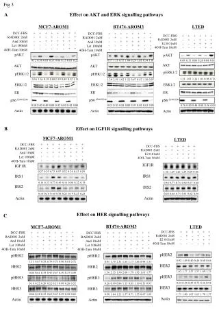
Download
1 / 18
180 likes | 319 Views
1 Department of Geodesy and Surveying of the Aristotle University of Thessaloniki 2 Department of Surveying Engineering of the Technological Educational Institute of Athens 3 School of Rural and Surveying Engineering of the National Technical University of Athens.

E N D
1Department of Geodesy and Surveying of the Aristotle University of Thessaloniki 2Department of Surveying Engineering of the Technological Educational Institute of Athens 3School of Rural and Surveying Engineering of the National Technical University of Athens First Validation of the Hellenic Vertical Datum as a Prerequisite for the Efficient Disaster and Resource Management: The “ELEVATION” Project D. ANASTASIOU3, D. GAIFILLIA2, A. KATSADOUROU1, E. KOLYVAKI1, X. PAPANIKOLAOU3, M. GIANNIOU2, G. S. VERGOS1 and V. PAGOUNIS2 Presented at the FIG Commission 3 Workshop 2012 Spatial Information, Informal Development, Property and Housing
Importance of horizontal and vertical networks • Technical Projects are based on well established horizontal and vertical reference networks: • confrontation of a natural disaster • determination of crustal deformations • calculation of small distortions of a construction Precise knowledge of the location successful crisis management Horizontal control networks: determination with high precision (GPS/GNSS applications) Vertical control networks: difficulties due to the effect of the earth's gravity field • exploitation of surface water and underground resources • construction of large technical infrastructures • confrontation of environmental issues Main objective: Evaluation of the Hellenic Vertical Reference System (VRS) In the frame of the pan-European effort for the establishment of a common European Vertical Network FIG 2012 Athens, 10-14/12 Anastasiou et al.
Vertical networks for surface water Tzanou and Vergos 2012 FIG 2012 Athens, 10-14/12 Anastasiou et al.
Vertical networks for spatial planning Environmental and Geo Data Remote Sensing Data Height Data Basic Cartographic Background Savvaidis et al. 2012 Geo-database& Spatial Planning FIG 2012 Athens, 10-14/12 Anastasiou et al.
Theoretical Background Orthometric Height: the distance along the plump line from Earths’ surface to the geoid Ellipsoid Height: the distance along the vertical from Earths’ surface to the reference ellipsoid Geoid Height: the distance along the vertical from the geoid to the reference ellipsoid • Geoid:is an equipotential surface of the Earth’s gravity field that is approached by the MSL at a global scale, provided that the effects of tides and currents are removed • Ellipsoid:is not a physical surface and is used only as a (mathematical) model of the Earth’s surface for horizontal positioning, due to its simplicity. The ellipsoid is the reference surface utilized by the geodetic satellite missions FIG 2012 Athens, 10-14/12 Anastasiou et al.
Description of the project Areas under study Height benchmarks of the national trigonometric and leveling networks Attica Thessaloniki Assessment of internal accuracy of the two networks: • Geoid heights from local gravimetric models and global geopotential models • Satellite and conventional geodetic measurements for the determination of ellipsoidal and Helmert-type orthometric heights respectively : • Static GPS observations • Classical spirit leveling • Special Trigonometric leveling Due to earlier work, all three types of height information are available for some benchmarks in both areas. Therefore the work carried out referred to additional measurements in order to fill-in the areas under study. FIG 2012 Athens, 10-14/12 Anastasiou et al.
Leveling data identification Measurement at benchmarks (BMs) selected from the National Trigonometric and Leveling Network, established by the Hellenic Military Geographic Service (HMGS) during 1963 – 1986 In order to guarantee the connection to the national horizontal and vertical networks (Many benchmarks have been totally destroyed or they are not in a good condition) Identification in Attica 157 height BMs were searched 27 height BMs were found Identification in Thessaloniki 28 height BMs were searched 10 height BMs were found FIG 2012 Athens, 10-14/12 Anastasiou et al.
Leveling measurements • Part of the leveling BMs found were chosen due to accessibility and reliability factors • Since GPS measurements cannot be performed directly on height BMs, collocated BMs were established at short distances in order to measure both orthometric and ellipsoidal heights • Two types of techniques were applied: • The two techniques were applied between height BMs and also between BMs and height BMs • 10 height differences were measured in Attica and 12 in Thessaloniki • classical spirit leveling • special trigonometric leveling FIG 2012 Athens, 10-14/12 Anastasiou et al.
Special Trigonometric Leveling Starting point Ending point The tripod T1 together with the total station is placed close to R1. The leveling rod S1 is placed over R1. The total station is used like a leveling instrument as it scopes the rod horizontally in direct and inverted scope positions. The tripod T2 together with the target is placed next to R2. The total station measures the vertical angle and the slope distance from T1 to T2. The total station changes position with the target and we measure the vertical angle and the slope distance from T2 to T1. Finally we use the total station as leveling instrument and we scope the rod S2. (If the distance R1R2 is long, it is suggested that the observations be repeated several times to conclude in an average value) FIG 2012 Athens, 10-14/12 Anastasiou et al.
Leveling Results ? FIG 2012 Athens, 10-14/12 Anastasiou et al.
GPS data identification • Trigonometric BMs • Newly established reference points located in a short distance from the height BMs FIG 2012 Athens, 10-14/12 Anastasiou et al.
GPS measurements • Static measurements with dual frequency receivers to reduce the influence of ionosphere • HEPOS stations near Attica and Thessaloniki were used as reference stations • Measurement Parameters: • Occupation time of at least 60 minutes • Logging rate 15 s • Elevation mask 10o • Antenna height measurements are characterized by an accuracy of ±1 mm • The reference point is at the top of the benchmark • The uniform equipment and procedure for the antenna height measurements provide homogeneity and high accuracy, with variations of the order of 2-3 cm • The errors in reading or typing the antenna height, which are a common source of errors in GPS measurements, can be avoided FIG 2012 Athens, 10-14/12 Anastasiou et al.
HEPOS permanent stations • Calculation of the coordinates of the BMs in the HTRS07 datum • High accuracy and homogeneity • Smaller baseline lengths (<25 km) compared to using the EUREF Permanent Network • Dense network all over Greece and especially in Attica and Thessaloniki • Data available atany observation rate unlike the EPN data (observation rate = 30 s) Stations near Attica Stations near Thessaloniki FIG 2012 Athens, 10-14/12 Anastasiou et al.
GPS processing approaches GPS processing software package: Leica Geo Office (LGO) The points are solved from the nearest HEPOS reference station The points are solved from the next nearest HEPOS reference station A least squares adjustment is computed for each point using the two baselines connecting the point to the HEPOS stations Baselines (short and long) in Attica Baselines (short and long) in Thessaloniki FIG 2012 Athens, 10-14/12 Anastasiou et al.
GPS results for both the shortest and the longest baselines Geodetic coordinates in HTRS07 and standard deviations for Attica Geodetic coordinates in HTRS07 and standard deviations for Thessaloniki • Some points (outlined with red) were not solved from both stations because the averaging limit was exceeded • limited satellite visibility due to obstacles • disrupted L2 measurements due to electromagnetic interferences in the areas of the BMs FIG 2012 Athens, 10-14/12 Anastasiou et al.
Closing and Relative error • Closing error: • depends on the loop length • Relative error: • ranges between 0.04 - 3.71 ppm • indicates the quality of the • GPS data FIG 2012 Athens, 10-14/12 Anastasiou et al.
Conclusions • Height information of high accuracy and reliability in a common reference system is essential • Given the pan-European effort for the establishment of a common European Vertical Network, the validation of the Hellenic VRS seems an one-way road decision • The validation of the national vertical reference network and the establishment of its connection to the European VRS will aid cross-border transport, infrastructure, planning and environmental management • Vertical networks as geodetic infrastructures, provide accurate information about fundamental properties of the Earth as they change over time and have led to many scientific, civil, military, and commercial application • Height information is an indispensible component of engineering works, spatial planning and protection/conservation of the natural and built environment • Future Plans • Development of a geographical information system combining height and property information • This system will be used to monitor and record changes in order to prevent illegal constructions, so it will give a new quality level for managing the documents of real estate cadastre • Natural hazards confrontation, via more equitable decisions in crisis situation, can be done using an accurate representation of the physical environment and its interdependency with the human activities FIG 2012 Athens, 10-14/12 Anastasiou et al.
Thank you for your attention Acknowledgements The present work was carried out in the frame of “Archimedes III – Funding of research groups in T.E.I.”, co-financed by the E.U. and national funds under the Operational Program “Education and Lifelong Learning 2007-2013”