Download
1 / 10
100 likes | 177 Views
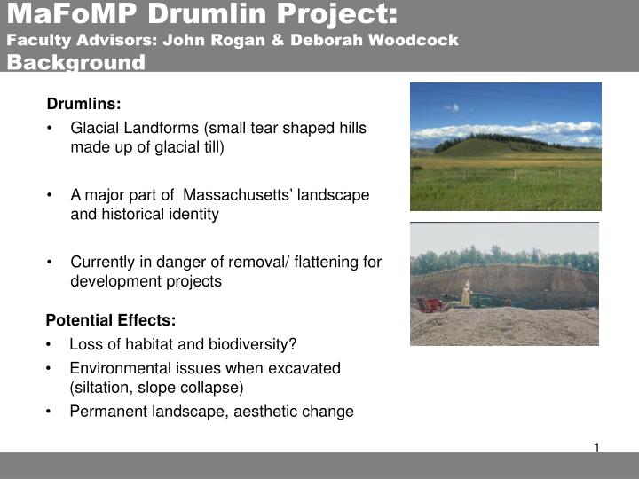
MaFoMP Drumlin Project: Faculty Advisors: John Rogan & Deborah Woodcock Background. ASTER. Drumlins: Glacial Landforms (small tear shaped hills made up of glacial till) A major part of Massachusetts’ landscape and historical identity

E N D
MaFoMP Drumlin Project: Faculty Advisors: John Rogan & Deborah WoodcockBackground ASTER • Drumlins: • Glacial Landforms (small tear shaped hills made up of glacial till) • A major part of Massachusetts’ landscape and historical identity • Currently in danger of removal/ flattening for development projects • Potential Effects: • Loss of habitat and biodiversity? • Environmental issues when excavated (siltation, slope collapse) • Permanent landscape, aesthetic change
Drumlin Project: Research Goals ASTER • Research Goals: • Survey drumlin fields and document change • Generate and create a database of Digital Elevation Models (DEM) which coincide temporally with the MaFoMP landcover map products • Present results to land management and conservation communities • Pilot Study: • Survey drumlins and document change within the towns of Stow, Hudson & Marlborough, MA • Assess accuracy and perform geomorphometric change analysis on DEMs
Drumlin Project:Methods • Methodology: • Utilize ASTER DEMs • Resolution: 15m • Coverage: 3600 Sq Km • Available data: 2001 - 2006 • Use DEMs and Drumlin Database to survey and plot drumlin locations • Use two DEMs from 2002 & 2006 to conduct geomorphometric analysis • Find locations and quantify change through image differencing • Conduct accuracy assessment Geomorphometric Analysis: Image Differencing DEM Time 1 DEM Time 2 DEM Time 1 Time 1
Drumlin Project:Overview of Literature • ASTER DEM Accuracy Assessment: • 16m average accuracy reported • Depends on landscape: (Aniello; Buyuksalin et al) • Flat: 10 – 15m • Mountainous: 29 – 60m (Kamp et al 2003) • Open areas: 12 – 25m • Forested areas: 31m (Kamp et al 2003; Poli et al) • Accuracy comparable to USGS 1 arc second DEM (Aniello) • ASTER DEM has less gaps, better coverage, more detail than other sensors (Buyuksalin et al) • Gaps in areas with clouds and flat water DEM Time 1 Time 1
Drumlin Project:Overview of Literature • ASTER DEM Accuracy Assessment Methods: • Compare Landsat & ASTER images (Kaab et al 2002) • Compare landcover maps with DEM to assess accuracy in regards to location of trees (Poli et al) • Compare topographic maps with DEM (Goncalves et al; Hirano et al 2003; San et al 2005) • Any correlation? • Produce image difference maps • Produce profiles • GCP points critical to accuracy (Goncalves et al; San et al 2005) • As number of GCPs increases, accuracy increases: 60 GCPs good amount • Manual Tie Points (TP) with GCPs increases accuracy • Ground Check Points: (Cuartero et al) • 315 points with differential GPS • Compare DEM-Z values with “true” check pts DEM Time 1 Time 1
Drumlin Project:Overview of Literature • Use of ASTER DEMs: • Orthophoto generation from IKONOS & creation of geologic maps (Aniello) • Solar radiation & glacier geomorphic analysis (Kamp et al 2003) • Multi-temporal changes can be monitored with “good accuracy” (Poli et al) • ASTER DEMs are restricted in change detection: e.g. high mountains (Kaab et al 2002) • Change detection use requires: • Surface features with sufficient contrast that exceed the image resolution and are present over time • Change must be of high magnitude: ASTER not sufficient to monitor glacier thickness- change is to small DEM Time 1
Drumlin Project:Current Progress & Future Work • Current Progress: • Reviewed literature for DEM change detection: • Best data source • DEM accuracy assessment & methods • DEM use • Acquired ASTER DEM data • Created drumlin database from D. Woodcock’s surveys • Currently drafting drumlin location and change map based off of complied database for D. Woodcock pilot study paper DEM Time 1 Time 1
Drumlin Project:Draft of Pilot Study Map DEM Time 1 Time 1
Drumlin Project:Current Progress & Future Work • Current Progress: • Reviewed literature for DEM change detection: • Best data source • DEM accuracy assessment & methods • DEM use • Acquired ASTER DEM data • Created drumlin database from D. Woodcock’s surveys • Currently drafting drumlin location and change map based off of complied database for D. Woodcock pilot study paper Future Work: • Finalize draft of pilot study map for D. Woodcock • Assess DEM change detection accuracy with acquired data • Finalize methodology • Begin DEM Drumlin analysis DEM Time 1 Time 1
Drumlin Project:Bibliography • Bibliography: • Aniello, Peter. “Using ASTER DEMs to Produce IKONOS Orthophotos” Space Imaging • Cuartero, A.; A.M. Felicisimo, and R.J. Ariza. “Accuracy of DEM Generation from Terra-ASTER Stereo Data” Commission VI, WG VI/4 • Goncalves J.A., and A.M. Oliveira. “Accuracy Analysis of DEMs Derived from ASTER Imagery” Commission III, WG III/2, Science Faculty University of Porto, Portugal • Hirano, Akira; Roy Welch, and Harold Lang. “Mapping from ASTER stereo image data: DEM validation and accuracy” Journal of Photogrammetry & Remote Sensing Vol. 57 (2003): 256-370 • Kaab, A.; C. Huggel; F. Paul; R. Wessels; B. Raup; H. Kieffer, and J. Kargel. “Glacier Monitoring from ASTER Imagery: Accuracy and Applications” EARSeleProceedings- Workshop Observing our Cryosphere from Space No. 2 (March 11-13 2002): 43-53 • Kamp, Ulrich; Tobias Bolch, and Jeffrey Olsenholler. “DEM Generation from ASTER Satellite Data for Geomorphometric Analysis of Cerro Sillajhual, Chile/Bolivia” ASPRS 2003 Annual Conference Proceedings: Anchorage, AK (May 2003) • Poli, D.; F. Remondino, and C. Dolei. “Use of Satellite Imagery for DEM Extraction, Landscape Modeling and GIS Applications” Institute of Geodesy and Photogrammetry, Zurich Switzerland • San, B.T., and M.L. Suzen. “Digital elevation model (DEM) generation and accuracy assessment from ASTER stereo data” International Journal of Remote Sensing Vol. 26, No. 22, 20 (November 2005) DEM Time 1 Time 1 Sam Blanchard Fall 2007