Download
1 / 85
1.11k likes | 1.76k Views
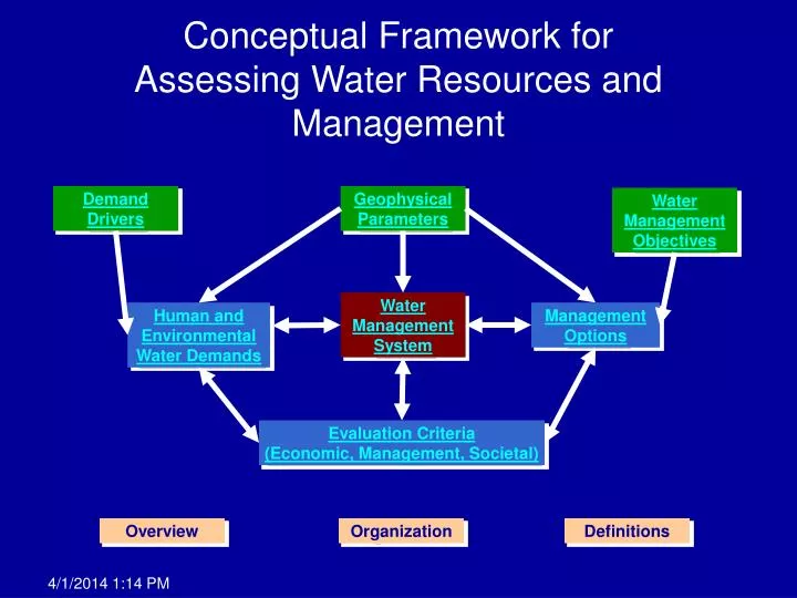
Conceptual Framework for Assessing Water Resources and Management. Demand Drivers. Geophysical Parameters. Water Management Objectives. Water Management System. Human and Environmental Water Demands. Management Options. Evaluation Criteria (Economic, Management, Societal). Overview.

E N D
Conceptual Framework for Assessing Water Resources and Management Demand Drivers Geophysical Parameters Water Management Objectives Water Management System Human and Environmental Water Demands Management Options Evaluation Criteria(Economic, Management, Societal) Overview Organization Definitions
Overview (1 of 2) DWR and the Water Plan Advisory Committee developed a new planning framework that identifies broad objectives for the Water Plan including disclosure of all technical assumptions (see Chapter 1, Volume 1 of Update 2004). DWR and the Advisory Committee held several workshops with land use and resource planners, academics, policy analysts, and technical experts to build on and affirm Advisory Committee understanding about issues critical for the Water Plan to address. These conversations have been captured in mind maps that represent a web of relationships and ideas (See the Technical Guide, Volume 5). These discussions identified the desire to address various crosscutting issues such as environmental objectives, land-use planning, and economics in different scenarios in this Water Plan. Quantifying these issues will require significantly more technical and quantitative information than for previous Water Plans. MORE BACK
Overview (2 of 2) Types of technical assumptions and information needs that have been identified to satisfy the broad objectives of the Water Plan can be described as: • Data – factual (or observed) information, such as measurements or statistics (e.g., gauged flows in a river, population as measured by census, and salinity of a water sample). Sets of data can be raw (as taken from measurement devices) or elaborated (modified slightly as part of quality assessment and quality control measures, or interpreted (supplemented to address missing measurements). • Relationships (or system interactions) – descriptions of how the social, physical, and environmental systems affect or are affected by the status of water supply and water use in California (e.g., how releases from a reservoir affect water temperature at a point in a river downstream, the irrigated crop acreage in a region and the expected market conditions for each crop, and snow pack conditions in February and the delivery of SWP water). • Estimates – inferred, derived and/or forecasted quantities based on available data, defined relationships, and other assumptions (e.g., population forecasts for the Los Angeles area in 2030, groundwater flows between sub basins, future available water deliveries, and the cost to implement water conservation best management practices). BACK
Organizing Information Given the large quantity and complexity of data, relationships, and estimates desired, the update team has organized the requested information according to their potential interactions. The color key below explains the high-level interactions illustrated by the graphical Conceptual Framework. • The three light green boxes across the top represent static information set by the user, which does not change for a given scenario. • The three light blue boxes contain information that will be quantified using analytical tool(s) that explicitly consider the inter-relationships with other data, relationships, or estimates (or dynamic estimates). • The red box in the center represents where most of the decisions are made within the analytical tools (often called decision variables). BACK
Definitions (1 of 3) • Demand Drivers – Factors that influence the calculation of water demands, which are not directly controlled by water management activities. For example, population, population density, land use patterns, and economic activity. • Geophysical Parameters – Factors that represent the basic hydrology, hydrogeology, geology, and climate, which form the natural constraints of the system. For example, precipitation, soil properties, and aquifer transmissivity. • Water Management Objectives – Objectives developed by policy makers for desired outcomes of the water management system while considering the various constraints, competing demands, and resource strategies. For example, desired water quality and desired water reliability at a particular location and time and for a particular use. MORE BACK
Definitions (2 of 3) • Human and Environmental Demands – Dynamic consumptive and non-consumptive demands for water that fluctuate based on the climate, economy, changes in water use efficiency, population growth, and other factors. Consumptive demands include activities that deplete water from the water management system by evaporation, evapotranspiration, or flows to saline water bodies. Non-consumptive demands include activities that require a specific quantity of water at a particular location and time, but do not deplete from the water management system. This includes releasing water for hydropower production, instream flows, or municipal water use that flows to a wastewater treatment facility and is later released to a stream or recharged to groundwater. • Management Options – Management options are the numerous resource strategies available to water managers to improve operation of the water management system and are heavily influenced by the desired water management objectives. This includes actions like water use efficiency, surface or groundwater storage, floodplain management, and ecosystem restoration. MORE BACK
Definitions (3 of 3) • Evaluation Criteria – Factors that serve as dynamic evaluation criteria to guide policy makers, water managers, and the public about how well a particular hypothetical scenario and operation of the water management system is at meeting water management objectives. This includes things like economic cost of implementing different resource strategies, environmental benefits, water reliability, and improvements in water quality. • Water Management System – The system of man made and natural water storage and conveyance features where the water management decisions are implemented. This includes location, storage and flow capacities, and operating criteria of reservoirs, canals, wetlands, floodplains, lakes, rivers, and groundwater basins. BACK
Input | Urban |Output Input | Agricultural | Output Input| Environmental | Output Input | Flood Management | Output Input | Hydropower | Output Input | Navigation | Output Input | Recreation | Output WATER DEMANDS Water Quantity Water Quality BACK
Climate Factors Surface Hydrology Hydrogeology GEOPHYSICAL PARAMETERS Water Quantity Water Quality BACK
Input|Water Reliability | Output(Urban) Input| Water Reliability| Output(Agricultural) Input| Water Reliability| Output(Environmental) EVALUATION CRITERIA (1 of 4) Water Quantity Water Quality MORE BACK
Input| Catastrophic| Output Vulnerability Input| Cost of Reliability | OutputEnhancement Input| Cost of Unreliability | Output Input| Energy Use | Outputand Production EVALUATION CRITERIA (2 of 4) Water Quantity Water Quality MORE BACK
Input| Environmental Justice | Output Input| Flood Management | Output Input | Groundwater Overdraft | Output Input| Public Trust | Output Input| Recreation | Output EVALUATION CRITERIA (3 of 4) Water Quantity Water Quality MORE BACK
Input| Regional Self-Sufficiency | Output Input| Third Party Impacts | Output Input| Tribal Resources | Output Input| Water Quality | Output EVALUATION CRITERIA (4 of 4) Water Quantity Water Quality BACK
WATER MANAGEMENT SYSTEM Input Output BACK
Net Solar radiation Air Temperature Relative Humidity Wind speed Dew point temperature Cloud cover Evaporative Demand Microclimates – temporal/spatial variations CLIMATE Factors BACK
Aquifer Types Confined Unconfined Perched Isotropic Anisotropic Aquifer Permeability / Hydraulic Conductivity Subsidence Groundwater elevation Piezometric Surface/Pore Pressure Aquifer Transmissivity Storativity Stratigraphy Porosity Aquifer Homogeneity / Heterogeneity Connection to surface water bodies Aquifer Zones & Depths HYDROGEOLOGY Factors BACK
Precipitation (intensity, duration, frequency) Upper basin shape, size and topography Basin soil type Basin soil erosion Streambed grain size distribution Stream bank stability and bank grain size distribution Soil infiltration Land use (vegetation cover, pavement) Surface vegetation ET Lower basin ground slope Stream channel shape and slope Snow accumulation Stream reach rating curve SURFACE HYDROLOGY Factors BACK
WATER MANAGEMENT SYSTEM Input (1 of 4) • Applied water demands for ag/urban/env uses • Available / desired / required water quality (stream, lake, aquifer) • Stream inflows at system boundary • Location, operating criteria, and capacities of reservoirs, conveyance facilities, and natural channels, recharge facilities, and groundwater basins • Institutional response to drought, climate change, and catastrophic events MORE BACK
WATER MANAGEMENT SYSTEM More Input (2 of 4) • Stream rating curves • Desired / required instream flow and lake levels • Available / desired / required water temperature • Stream flow velocities, streambed grain size, bank stability, bank material grain size • Available water management strategies and operating criteria MORE BACK
WATER MANAGEMENT SYSTEM More Input (3 of 4) • Groundwater well location, capacities, operation criteria, and ordinances • Groundwater management objectives • Location and capacity of water and wastewater treatment facilities • Interconnectedness of local, regional, state water systems MORE BACK
WATER MANAGEMENT SYSTEM More Input (4 of 4) • Geology and hydrogeology info • Specific yield • Transmissivity • Aquifer zones / depths • Artificial recharge areas / capacities • Natural recharge areas / capacities • Operating criteria for managed wetlands including flood-up and drawdown BACK
WATER MANAGEMENT SYSTEM Output (1 of 3) • Agricultural/Urban/Environmental recreation, navigation, hydropower water use • Water quality by source • Strategy implementation • Streamflows and timing by reach • Surface water reservoir inflow, releases, storage level, losses • Groundwater recharge, pumping, subsurface inflow/outflow, storage levels • Source of water for deliveries MORE BACK
WATER MANAGEMENT SYSTEM More Output (2 of 3) • Stream-Aquifer interaction • Return flows by reach • Water temperature by stream reach / lake level • Sediment transport by stream reach • Deep percolation of applied water and precipitation • Conveyance losses • Extent of Ag drainage problems • Hydropower generation • Volume of water and wastewater treatment MORE BACK
WATER MANAGEMENT SYSTEM More Output (3 of 3) • Water quality of discharges to surface water and groundwater BACK
ENVIRONMENTALWATERDEMANDS Input (1 of 3) • Acreage and location of riparian, refuge, wetland habitats • ET of riparian, managed refuge, and wetland habitats • Inventory of fish and wildlife dependent on riparian, refuge, or wetland habitat (abundance, locations, habitat needs, water quality needs, temperature needs) • Available water supplies by source MORE BACK
ENVIRONMENTALWATERDEMANDS More Input (2 of 3) • Fish and wildlife biological objectives for abundance, locations, habitat needs, water quality needs, temperature needs • Fish and wildlife legal requirements for abundance, locations, habitat needs, water quality needs, temperature needs • Historical information on river flow, riparian habitat, bank erosion, and channel movement by reach • ET/ETAW of applied water demands for riparian, refuge, and wetland habitats MORE BACK
ENVIRONMENTALWATERDEMANDS More Input (3 of 3) • Inventory of management practices of refuges and managed wetlands • Habitat type including vegetation and open water • Required / desired water depths • Required / desired water circulation • Other water related environmental objectives • Effective precipitation • Existing commitments for future water use efficiency at managed wetlands • Legal requirements for abundance, locations, habitat, flow, water quality, and temperature BACK
ENVIRONMENTALWATERDEMANDS Output (1 of 2) • Total and applied water demands for riparian, refuge, and wetland habitat • Desired instream flow and lake levels in specific stream reaches and lakes to sustain riparian, refuge, and wetland habitat • Desired water quality in specific stream reaches and lakes to sustain riparian, refuge, and wetland habitat • Desired water temperature in specific stream reaches and lakes to sustain riparian, refuge, and wetland habitat MORE BACK
ENVIRONMENTALWATERDEMANDS More Output (2 of 2) • Desired instream flow and lake level requirements to sustain fish and wildlife species • Desired water quality in specific stream reaches and lakes to sustain fish and wildlife species • Desired water temperature in specific stream reaches and lakes to sustain fish and wildlife species • Desired instream flows in specific stream reaches and lakes to maintain river morphology BACK
AGRICULTURALWATERDEMANDS Input (1 of 4) • Climate Factors • Population and population growth • Crop ET & ETAW modeling • Soil type • Available soil moisture holding capacity • Soil depth • Growing season • Crop coefficients • Rooting depth • Managed allowable depletion • Soil infiltration • Deficit irrigation Net Solar radiationAir TemperatureRelative HumidityWind speedCloud coverPrecipitationEvaporative DemandDewpoint temperatureMicroclimates – temporal / spatial variation MORE BACK
AGRICULTURALWATERDEMANDS More Input (2 of 4) • Crop type • Regional crop practices • Soil salinity (leaching requirements) / Planned over-irrigation • Soil water holding capacity/ Soil moisture retention • Agricultural Practices (Permanent, Raw, Multiple Crops) • Land availability, suitability • Conservation easements • Flood control easements • Urbanization MORE BACK
AGRICULTURALWATER DEMANDS More Input (3 of 4) • Effective precipitation • Available water supplies by source • Cost of water supplies by source • Available water quality by source • Irrigation method • Consumed fraction • Existing commitments for future water use efficiency • Crop pattern • Crop acreage MORE BACK
AGRICULTURALWATER DEMANDS More Input (4 of 4) • Current drainage problems/High water table areas • Livestock water use (Number and type of livestock) • Applied water reusable fraction • Water quality needs for plant production by crop type • Cultural practices BACK
AGRICULTURAL WATER DEMANDS Output • Crop production (tonnage) • Total Ag Water Demand • Water quality requirements for surface water / groundwater deliveries • Total Ag ET / ETAW / EP BACK
RECREATION Input • What type of recreational activities (water contact / non-water contact) • Where recreational activities take place • When recreational activities take place • Annual number of people who participate in recreational activities • Future population / recreational usage BACK
RECREATION Output • Time and quantity of stream flows required to support stream-based recreation • Timing and lake levels required to support lake-based recreation • Desired / required water quality to support recreation • Desired / required fish and wildlife abundance to support recreation • Desired / required habitat to support recreation BACK
HYDROPOWER Input • Forecast of hourly reservoir inflows • Forecast of hourly power usage and generation • Forecast of hourly power market rates • Location, storage capacity, conveyance capacity, and generation capacity of hydropower facilities • Operating criteria for hydropower facilities • Water quality, water temperature, and recreational requirements affecting hydropower facilities • Trends / changes in hydropower operation due to FERC re-licensing and other legal requirements BACK
HYDROPOWER Output • Desired reservoir releases for hydropower generation • Maximum potential hydropower generation • Maximum potential hydropower consumption BACK
FLOOD MANAGEMENT Input • Forecast of hourly reservoir inflows • Location, operating criteria, and capacities of flood management facilities • Regulatory storage and release requirements for flood management • Management policies (e.g., State Floodplain Management Task Force) • Land use policies BACK
FLOOD MANAGEMENT Output • Desired / required reservoir storage levels and releases for flood management BACK
URBAN WATER DEMAND Input (1 of 2) • Climate Factors • Available water supplies by source • Cost of water supplies by source • Population and growth rate (by class, dwelling, etc.) • Unit indoor/outdoor use (per capita, per household, etc.) • Required water quality for urban uses Net Solar radiationAir TemperatureRelative HumidityWind speedCloud coverPrecipitationEvaporative DemandDewpoint temperatureMicroclimates – temporal / spatial variation MORE BACK
URBAN WATER DEMAND More Input (2 of 2) • Housing and land use characteristics (density, mix, availability, suitability, policies) • Available water quality by source • Existing commitments for future water use efficiency • Economic characteristics (employment, commercial, industrial, household income, etc.) BACK
URBAN WATER DEMAND Output • Water demand by customer class (single family, multifamily, commercial, industrial, landscape) • Water demand for landscaping • Water quality requirements for surface water / groundwater deliveries • Water use reduction due to conservation programs BACK
Total population Population density Population distribution Commercial activity Commercial activity mix Total industrial activity Total industrial activity mix Agricultural production Total crop area (Includes multiple cropping) Crop unit water use Existing commitments for future water use efficiency Land use Household income Seasonal / permanent irrigated crop acreage and land acreage. DEMAND DRIVERS Factors BACK
NAVIGATION REQUIREMENTS Input • Inventory of legal and desired flow requirements by stream reach and lake for navigation BACK
NAVIGATION REQUIREMENTS Output • Instream flow and lake level requirements to meet navigation requirements BACK
Ag. Lands Stewardship Agricultural Use Efficiency Conj. Mgmt / GW Storage Conveyance Desalination Drinking Water Treatment & Distribution Economic Incentives/ Pricing Ecosystem Restoration Floodplain Management GW / Aquifer Remediation Matching WQ to Use Pollution Prevention Precipitation Enhancement Recharge Area Protection Recycled Municipal Water Surface Storage – CALFED Surface Storage – Regional/Local System Reoperation Urban Land Use Management Urban Runoff Management Urban Water Use Efficiency Water-Dependent Recreation Water Transfers Watershed Management Other Strategies (R&D) MANAGEMENT OPTIONS BACK
Demand Reduction, Reallocation of Supply, and Supply Augmentation Improve Drought Preparedness Improve Water Quality Operational Flexibility & Efficiency Reduce Flood Impacts Environmental Benefits Energy Benefits Recreational Opportunities Reduce Groundwater Overdraft Reduce Pollution Reduce Ag Drainage Impacts Fish and wildlife objectives for abundance, locations, habitat flow, water quality, and temperature WATER MANAGEMENT OBJECTIVES Objectives BACK
Input Population Water rates Housing type Price elasticity Willingness to accept shortages Willingness to pay to avoid shortages Contingency options Actual water deliveries Requested water deliveries Evaluated mix of water management options Desired/Required water quality Land use Land suitability Unit cost for water treatment Pumping cost EVALUATION CRITERIA:WATER RELIABILITY (URBAN) BACK
Evaluation Criteria:WATER RELIABILITY (URBAN) Output • Water supply exceedence curve • Commercial and industrial activity • Business production • Employment • Relationship between development density and water use BACK