Download
1 / 8
80 likes | 194 Views
CryoSat: showing the way to a future of improved ocean mapping. Walter H. F. Smith NOAA Lab for Satellite Altimetry Silver Spring, Maryland. Ocean altimetry of VD, G, and B. Sea surface slope reveals Vertical Deflection of Gravity, and may be correlated with Bathymetry.

E N D
CryoSat:showing the way to a futureof improved ocean mapping Walter H. F. Smith NOAA Lab for Satellite Altimetry Silver Spring, Maryland
Ocean altimetry of VD, G, and B Sea surface slope reveals Vertical Deflection of Gravity, and may be correlated with Bathymetry. CryoSat offers first space-test of improved resolution of VD, G & B, with many applications.
Resolve Control on Ocean Mixing Rate Slower Mixing Faster Mixing Smoother bottom Rougher bottom Spatial variations in bottom roughness change mixing rates by order of magnitude (vertical diffusivity < 105at left and > 104 at right; actual in situ data shown). 10–30 km l bathymetry controls mixing Higher-resolution altimetry can map the controlling scales.
Increase seamount detection 17x Probably 50,000 seamounts 1 km tall remain undetected. 2x better seamount resolution will find 17x more seamounts.
CryoSat: showing the way ahead • CryoSat is the first non-repeat-track (“geodetic orbit”) altimeter since ERS-1 (1994) and Geosat (1985). • Sandwell et al. will use CryoSat conventional altimeter mode data over global ocean to improve marine gravity field. • CryoSat SAR mode offers first space demonstration of delay-Doppler altimetry. • Raney et al. will demonstrate improved H and reduced sensitivity to SWH over ocean surface. • Smith et al. will demonstrate improved resolution of VD, G & B over oceans.
North slope East slope Ocean mapping beyond CryoSat An ocean mapping mission needs: • “Geodetic” (non-repeat) orbit • SAR-mode over all ocean • Moderate inclination CryoSat’s polar orbit resolves only N-S component of VD.
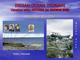
Envisat measured the Indian Ocean tsunami ESA’s Envisat altimeter measured a sea level anomaly on 26 Dec 2004 associated with the tsunami. These data are being used at NOAA to improve a model for the tsunami source mechanism and wave field. Altimeters are the only source of deep-water data on this tsunami. A NOAA press release credits ESA for this valuable asset and contribution. See http://www.noaanews.noaa.gov/stories2005/s2365.htm