Download
1 / 3
30 likes | 175 Views
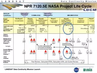
TIME SERIES DATA PRODUCTS : Landsat-Class and VHS-Class Observatories. Samuel N. Goward Geography, U. Maryland Curtis Woodcock Geography, Boston University. Lots of Good News!. Landsat Data Continuity Mission (LDCM) Procurement near completion Planned Launched Data July 2011

E N D
TIME SERIES DATA PRODUCTS:Landsat-Class and VHS-Class Observatories Samuel N. GowardGeography, U. Maryland Curtis WoodcockGeography, Boston University
Lots of Good News! • Landsat Data Continuity Mission (LDCM) Procurement near completion • Planned Launched Data July 2011 • Technical specs substantial improvement • New Landsat Data Policy • No Cost Access – entire US Archive, level 1T, single formula imagery(1972-current) • National Land Imaging Program (DOI) • Responsibility for operational Landsat-class observations • GeoCover and GLS Datasets • Original dates reprocessed • Mid Decadal Dataset (circa 2005) in production
Priorities NASA Initiatives • Define and develop processing streams in support of environment/climate data records (third) • Multiple science requirements for Landsat-class observations (to be developed based on participant submissions) • New opportunities require new methodologies (R+D) • Ensure that NASA’s needs for high resolution observations are met (weekly global clear imagery?) • Undertake GLS 2010 (possibly using GEO Land Surface Imaging Constellation) (third) • Explore opportunities for providing a global sample of very high resolution data (less than 5m) in support of validation (fourth) • Secure existing Landsat holdings from IGS (consolidate at EDC) (first) • Achieve sustained consistent Landsat-class observations (second) NLIP Initiatives (needing NASA support)