Download
1 / 28
280 likes | 413 Views
NWS and Basin Management = Perfect Together!. Carol R. Collier, P.P., AICP Executive Director Delaware River Basin Commission April 19, 2010. Value of the NWS. Nationally - based on the National Collaborative Water Resources Conferences DRBC – Past and Future.

E N D
NWS and Basin Management = Perfect Together! Carol R. Collier, P.P., AICP Executive Director Delaware River Basin Commission April 19, 2010
Value of the NWS • Nationally - based on the National Collaborative Water Resources Conferences • DRBC – Past and Future
National Observations:Common needs for statewide planning Desire Comprehensive planning Seek Conflict resolution Need Data & info Desire Disaster planning Lack of funding Lack climate info Need technical assistance Widespread Issues Lack data/info Need models, analyses Lack funding Seek alternative water supplies Lack funding Desire comprehensive planning Isolated Issues 3
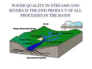
Delaware River Watershed Facts • 16 million people (about 5% of the U.S. population) rely on the waters of the basin • Drains 13,539 mi² , or 0.4 of 1% of the continental U.S. land area • 4 states, 42 counties, 838 municipalities • 25 Congressional Districts
Delaware River Longest Undammed River East of the Mississippi 330 miles
BASIN TRIVIA QUESTION???? What is the Connection between the Delaware River and Professional Sports?
DRBC Issues • Water Flows Highly Managed due to 1954 Supreme Court Decree • NYC allowed to divert up to 800 mgd out of basin • Changing Priorities – Water supply, fisheries, flood mitigation • Pollution • Major clean up ,but now toxics and emergent contaminants • Special Protection Waters • Flood of Record – 1955 • Drought of Record – 1960’s • Three Floods – 2004 – 2006
Value of NWS to DRBC • Basic data and AHPS • Flood potential, flow augmentation, river monitoring events • Always Improving Flood Warning System • Reservoir Flood Model – NWS, USGS and USACE • Strong Partner and Supporter
Future Issues • Climate Change • Sea Level Rise • Increased Storm Intensity • Increased Drought Probability • Increased Uncertainty • Impacts to Sensitive Headwaters • Natural Gas Well Drilling • Loss of Forest; increased Impervious cover • Changing Population Distribution/Water Demand
Sea Level Rise Global Sea Level Rise Regional Changes gravity, ocean currents and ocean density subsidence Global + Regional 0.45 + 0.27 = 0.72m (2.3 ft) 1.4 + 0.27 = 1.67m (5.5. ft) Model 0.5 meter rise 1.0 meter rise 1.5 meter rise
Changes in Snowpack and Timing of Snowmelt • There will be less snow in the winter; this affects water supply for many who depend on the melting of snowpack as a water source. The timing of snowmelt may also change, prompting water resource managers to change how water supply reservoirs are managed.
Salt Line (250 mg/l, 7 day avg) Water Supply Intakes RM 110 1960’s Maximum Normal R.M. 77 Data for determination provided by the U.S. Geological Survey and Kimberly Clark Corp.
Operating Plans New York City Delaware Basin Reservoirs drive the Basin wide Operating Plan. Cannonsville Pepacton Neversink Two Corps of Engineers Reservoirs drive Lower Basin Operating Plan Beltzville Blue Marsh Merrell Creek Reservoir Montague Trenton
Water Intakes at Risk from Drought and Sea Level Rise: location of the salt line at high tide during drought • Power • Exelon Delaware Generating Station • Exelon Richmond Generating Station • Philadelphia Gas Works Richmond • Industrial • Koch Material Co. • NGC Industries • Rohm and Haas Philadelphia • MacAndrew and Forbes Co. • Pennwalt Corporation • Sunoco • Public Supply • Torresdale Water Intake (provides • almost 60% of Philadelphia’s water supply) • New Jersey American Water Co. Tri-County Water Treatment Plant
Questions and Needs • Will there be adequate water supply? • Will we have enough water to push salinity down? • Do we need more structural storage for flood mitigation and water supply? • How will better stormwater control, LID, riparian buffers improve the system? • Need for basin-wide model to test scenarios • Probability factors, Range of conditions, Down-scaling
More Needs • Continued improvements to AHPS and nundation mapping • A more stable server for AHPS • Improved rainfall runoff model • Storm surge forecasting for tidal river
Thank You!! • NWS is one of DRBC’s strongest Partners • The management of the basin is dependent on NWS data, models and predictions