Download
1 / 25
250 likes | 256 Views
Loyola Dunes Restoration Ecology Survey. By: Mel Dunne and Amber Vignieri. Helpful Definitions. Primary Succession: occurring in an environment in which new substrate, devoid of vegetation and usually lacking soil is deposited

E N D
Loyola Dunes Restoration Ecology Survey • By: Mel Dunne and Amber Vignieri
Helpful Definitions • Primary Succession: occurring in an environment in which new substrate, devoid of vegetation and usually lacking soil is deposited • Secondary Succession: occurs on substrate that previously supported vegetation before an disturbance destroyed the plant life.
More Helpful Definitions • Native Species: species that normally lives and thrives in a particular ecosystem • invasive species: introduced species that adversely affect the habitats they invade economically, environmentally, and/or ecologically.
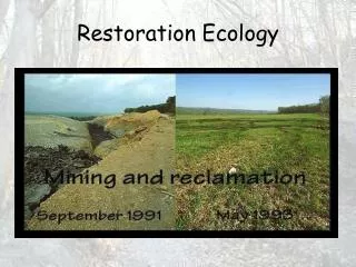
Purpose • Tracking the progression of cover over the dunes • Human foot traffic and other destructive practices threaten the developing ground cover • To measure the amount of land covered by various plant species in numerous areas of the site
Method • Divide Dunes into 3 sections • Choose 3 spots within section (use GPS) • Haphazardly toss 1 m2 PVC square 5 times from each spot • Photograph each time square lands • Calculate percent coverage
3 2 1
Waypoint coordinates dividing areas 2 and 3Waypoint 020N 42 00.396 W 087 39.434Waypoint 023N 42 00.422W 087 39.373
SPOT #1: N 42 00.389 W87 39.421 (Waypoint 021)
SPOT #1: N 42 00.389 W87 39.421 (Waypoint 021)
SPOT #1: N 42 00.389 W87 39.421 (Waypoint 021)
SPOT #1: N 42 00.389 W87 39.421 (Waypoint 021)
SPOT #1: N 42 00.389 W87 39.421 (Waypoint 021)
Spot # 2: N 42 00.401 W 087 39.402 (Waypoint 024)
Spot # 2: N 42 00.401 W 087 39.402 (Waypoint 024)
Spot # 2: N 42 00.401 W 087 39.402 (Waypoint 024)
Spot # 2: N 42 00.401 W 087 39.402 (Waypoint 024)
Spot # 2: N 42 00.401 W 087 39.402 (Waypoint 024)
Spot #3: N 42 00.410 W 087 39.386 (Waypoint 026)
Spot #3: N 42 00.410 W 087 39.386 (Waypoint 026)
Spot #3: N 42 00.410 W 087 39.386 (Waypoint 026)
Spot #3: N 42 00.410 W 087 39.386 (Waypoint 026)
Spot #3: N 42 00.410 W 087 39.386 (Waypoint 026)
Further Analysis • Why might the percentages be sporadic? • What environmental factors might play a role in cover degradation or success? • How can we ensure secondary succession to be...a success...? (Yea, we went there...)