Download
1 / 33
330 likes | 775 Views
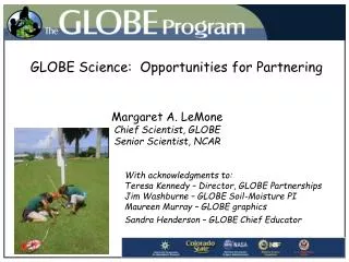
GLOBE Science: Opportunities for Partnering. Margaret A. LeMone Chief Scientist, GLOBE Senior Scientist, NCAR. With acknowledgments to: Teresa Kennedy – Director, GLOBE Partnerships Jim Washburne – GLOBE Soil-Moisture PI Maureen Murray – GLOBE graphics

E N D
GLOBE Science: Opportunities for Partnering Margaret A. LeMone Chief Scientist, GLOBE Senior Scientist, NCAR With acknowledgments to: Teresa Kennedy – Director, GLOBE Partnerships Jim Washburne – GLOBE Soil-Moisture PI Maureen Murray – GLOBE graphics Sandra Henderson – GLOBE Chief Educator
Overview of Talk What is GLOBE? substantially administratively who I am and what I do GLOBE science activities Potential opportunities How to partner with GLOBE Benefits of partnering with GLOBE Other groups to consider
GLOBE Program Overview • GLOBE is a hands-on inquiry-based international science and education program. • GLOBE students in primary and secondary schools in 107 different countries: • Take GLOBE environmental measurements using scientific protocols. • Report observations to the GLOBE data archive via the Internet, which can be accessed by anyone • Study Earth science topics using GLOBE maps and graphs and other GLOBE materials • Become more aware of their environment • Every GLOBE school has a GLOBE-trained teacher • Goal is to increase opportunities for student-scientist collaboration
protocols1 GLOBE Protocols Directions on taking measurements Site requirement Time(s) of day/year Instrument Technique Protocol selection criteria Research significance for Earth System. Doable by subset of K-12 students Developed/evaluated/overseen with competitively-selected scientists who Use GLOBE data in research Work with schools Help with questions Cover earth system system science In U.S. are supported by NSF
Hydrology: Water Temperature Water pH Dissolved Oxygen Electrical Conductivity Water Transparency Salinity Alkalinity Nitrates Freshwater Macroinvertebrates GLOBE Measurements Atmosphere: Air Temperature Relative humidity Surface temperature Precipitation Clouds Aerosols Water Vapor Air Pressure Automated Weather Stations Phenology Budburst Greenup Greendown Arctic Bird Migration Lilac Phenology Phenological Garden Seaweed Reproduction Ruby-Throated Hummingbirds Soils: Soil Temperature Soil moisture Characterization Bulk Density Particle Density Particle Size Distribution Soil pH Fertility Water Infiltration Terrain Land Cover (LC) LC Sampling Biometry LC mapping LC change detection Fire Fuel Ecology Time Location Site Characterization Courtesy: E. Levine and NASA/GSFC
Maps and graphs GLOBE Maps Data can also be displayed as contours in a map. This map displays the mean air temperature in Europe on May 23, 2003.
Six schools GLOBE Graphs Data from up to six schools can be displayed in the same graph. This is the maximum air temperature for schools in Australia, Benin and Finland. Air temperature and seasonal fluctuations can be seen for Northern and Southern hemispheres as well as Equatorial.
Students combine data with other data source GLOBE Maps GLOBE Students can compare their data with data from satellite and model data. This graphic compares GLOBE student data and NOAA Environmental Modeling Center data for April 7, 2003.
The Pieces GLOBE Program Office (Colorado) Oversight Partner support Web site Trainer training Funded by NASA ~80 U.S. Partners (all states but Nebraska) Local ‘franchises’ Teacher training Total funding ~3x Program Office 106 countries outside the U.S. 11 Groups of U.S. Scientists Use NASA satellite data Funded by NSF U.S. State Dept. Provides in-kind support Other supporters Peace Corps USAID UN GLO B E
Me My role: GLOBE Chief Scientist My responsibility: Maintain integrity of the program through currency and accuracy of science protocols and materials Increase use of GLOBE data by professional and student scientists My Background: Ph.D. Atmospheric Sciences (Univ. WA) 30 years as professional scientist 25 field programs (roughly) ~70 refereed journal articles, many more unrefereed. Ed/Outreach: textbooks, LEARN outreach program GLO B E Peggy LeMone NCAR PO Box 3000 Boulder, CO 80307 lemone@globe.gov
Now – Some examples of what is going on –and potential opportunities
Malaria Students use GLOBE measurements to ask questions about their local environment. This school in Benin graphed cases of malaria in the community with temperature and precipitation. GLO B E Cases of Malaria Temperature Precipitation
Scientist and students investigation compare MODIS Aerosol Optical Thickness (AOT) student observations – David Brooks, Drexel Inland site (DeBilt, Netherlands) Objective: to show that Measurements based on inexpensive hand-held instruments can be used to evaluate satellite-based methods of estimating aerosol optical thickness Top: Marken (island site) Bottom: The Hague (coastal site) Source: Brooks 2004 (GLOBE annual meeting) and De Vroom et al. 2003.
GLOBE/S’COOL Contrail Data: Earth Day Contrail Count-a-Thon 2004 Relationship between model ice RH at (400-150 mb) and Contrail Observations over CONUS (April 2004) Student Observations Earth Day Short-lived ARPS RUC Persistent Spreading Model comparisons: fig adapted from Dave Duda, Hampton Univ. Map: Lin Chambers, NASA Langley 0 RH relative to ice (percent) 100
Validation of Cloud Screening from the MODIS Sensor Dr. Kevin Czajkowski University of Toledo • Clouds obscure the ground from satellites. • Good cloud screening is needed to do remote sensing. • GLOBE student data showed that the MODIS cloud screening algorithm matched student overcast (ovc) or broken (bkn) cloud observations about 82% of • the time.
Student Observations MODIS Data Validation of the MODIS Snow Cover Product using GLOBE Student Observations Dr. Kevin Czajkowski University of Toledo • Snow cover is potentially an important indicator of climate change. • Satellites and in particular MODIS are well suited to observe snow cover globally. • GLOBE student observations have helped validate the MODIS snow algorithm showing that it is 93% accurate for the Great Lakes Region. Strange streak of MODIS-identified snow in Ohio that GLOBE observations showed was not snow.
Simulated and measured soil water content in the root zone 2. Validating ecosystem models (GAPS) 1. Comparing soil profile properties at different locations % clay 0 cm 20 cm 40 cm 60 cm 80 cm 100 cm Soil Characterization and Modeling using GLOBE Student Observations Elissa Levine NASA/GSFC School 1 School 2 School 1
Field Program Opportunities being pursued COPS and CSIP GLOBE One CUAHSI, SMEX NAME MIRAGE AMMA
GLOBE Field Campaign: GLOBE One: Black Hawk County, Iowa Objective: To determine the effects of corn and soybean tillage on the atmosphere, streams, soils, and phenology
Challenges with using GLOBE Protocols CHALLENGE: measure effect of land cover Response: T and RH at 1.5 m above “effective surface” Design weather-station mount that enables moving instruments upward as crops grow CHALLENGE: How to interpret differences between stations Response: Calculate expected T and RH profiles for different stages of crop growth, expected environmental conditions.
GLOBE as part of field Campaign: Martha Whitaker, Jim Washburne, Ty Ferre, Bart NijssenUniversity of Arizona Event-oriented GLOBE training Part of Soil Moisture Experiment 2003 (SMEX03) 1. Part of gravimetric soil moisture data set (measurements at 0-5 cm; 8-12 cm) 2. In-situ soil moisture compared to values from aircraft and spaceborne instruments 3. Teachers and students know measurements relevant to science Washburne is also doing this for NAME (North American Monsoon Experiment)
Web-based field programsfor students and others: Some examples proposed by GLOBE PIs and others Aerosol observations after volcanic eruption Rainfall measurements before and during a hurricane (or the remnants) – this is not always practical! Compare instruments or different instrument exposures (Sister Shirley experiment) BUT: it is important to report back to the observers!
Why is this work important? • Earth’s economy depends on weather and climate (and • the rest of the earth system) • Understanding/predicting weather and climate • requires good observations • Surface data help correct satellite algorithms • Future observational system include satellites • ground-based, and in-situ observations • Observations of earth system will help us understand • how to take good care of our environment • Student participation in such observations • Environmental awareness the first step in becoming • a good environmental steward • Participating in accessible hands-on science helps • develop critical thinking skills needed as a citizen • Inspire the next generation of scientists
To become involved, you could… • What: • Use web resources • Earth Exploration toolbook • Find scientist-mentors through • GLOBE office or GLOBE Partners • Work with a GLOBE Partner on • a regional field campaign • Sponsor a web-based field program • with GLOBE schools • How: • Check out the GLOBE web site • at www.globe.gov and follow menu • Contact us at the GLOBE Program • office lemone@globe.gov • Watch next talk! • (http://serc.carleton.edu/eet/globe/index.html)
Benefits of working with GLOBE • Existing infrastructure • GLOBE data stored on Web • GLOBE maps and graphs • GLOBE materials on Web • Earth system perspective • Scientist involvement • GLOBE Principal Investigators • GLOBE Scientists • GLOBE Program Office • Scientist mentors • Can answer perplexing questions • Can provide valuable research questions
costs Costs to involve GLOBE in a meaningful way • Involving GLOBE partner (depends on involvement) • Training Teachers/Community Members ($2K+ per session) • Review important GLOBE measurements • Add some from complementary • program • Instruments or test kits (costs vary) • Supplying them provides an incentive • Interactions with scientists • Takes time • Recommend finding committed scientist nearby • as well as scientist(s) involved remotely
Challenges • Time • For Scientists • For teachers and students • For building relationships • Expertise • Training needed for school and • community collaborators • Scientists need help with outreach • Priorities • University reward system • Time away from research • School curricula • School schedules
Organizations to team up with • Local school districts • Local nature or environmental organizations • Audubon Society • Watershed groups • Local museums • Scouts, 4-H, FFA • Local Weather Services (SOOs) • Local extension offices • Local Colleges and Universities • Senior Centers • Churches
Optimum Involvement: It doesn’t get better than this • Involves question(s) of local interest • Active local community collaborators • Schools • Community support for schools • Active local science collaborators • For Schools • Fits with curriculum • Fits with local/state/national • education standards Scientists and students partner in research…..
International Programin 107 countries Students collaboratewith scientists Hands-on science Atmosphere/ClimateHydrology Soils Land Cover/Biology Phenology Over 11 million environmental measurements taken