Download
1 / 16
160 likes | 260 Views
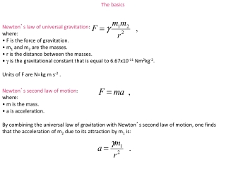
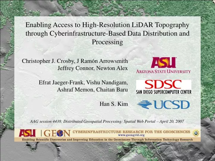
Enabling Access to High-Resolution LiDAR Topography through Cyberinfrastructure-Based Data Distribution and Processing. Christopher J. Crosby, J Ram ó n Arrowsmith Jeffrey Connor, Newton Alex Efrat Jaeger-Frank, Vishu Nandigam, Ashraf Memon, Chaitan Baru Han S. Kim.

E N D
Enabling Access to High-Resolution LiDAR Topography through Cyberinfrastructure-Based Data Distribution and Processing Christopher J. Crosby, J Ramón Arrowsmith Jeffrey Connor, Newton Alex Efrat Jaeger-Frank, Vishu Nandigam, Ashraf Memon, Chaitan Baru Han S. Kim AAG session 4438: Distributed Geospatial Processing: Spatial Web Portal – April 20, 2007
LiDAR (LIght Detection And Ranging) a.k.a ALSM (Airborne Laser Swath Mapping) • Airborne pulsed laser scanning system + differential GPS + inertial measurement unit (IMU) • > 30,000 points/second • Ground sampled at multiple points/sq. meter • ~ 15 cm vertical accuracy • ~$300 - $500 per sq. km acquisition cost http://coastal.er.usgs.gov/hurricanes/mappingchange/
Complete LiDAR Workflow 1. Survey 3. Interpolate / Grid USGS Coastal & Marine 2. Point Cloud x, y, z, … 4. Analyze / “Do Science”
The Challenge of Community LiDAR data LiDAR coverage of the southern San Andreas and San Jacinto faults - ~ 3.7 billion LiDAR returns - Very high-res., supports 25-50 cm DEMs
Multi-institution collaboration between IT and Earth Science researchers • Funded by NSF “large” ITR program • GEON Cyberinfrastructure provides: • Authenticated access to data and Web services • Registration of data sets and tools, with metadata • Search for data, tools, and services, using ontologies • “GEON was designed as an equal collaboration between Information Technology (IT) and Geoscience researchers, with the goal of developing an enabling IT platform to facilitate the next generation of Geoscience research.” • Scientific workflow environment • Data and map integration capability • - Visualization and GIS mapping Distributed Network GEON / ASU node
The Vision: Conceptual GEON LiDAR Workflow • Utilize cyberinfrastructure developed by GEON to offer online data distribution, DEM generation, and analysis of large LiDAR datasets. • Completely internet-based workflow: • Point cloud to visualization • Utilize modular web services to complete a variety of processing and analysis tasks. • Offer users control of processing and analysis parameters.
Current GLW features: • Interactive polygon data selection via WMS map • Attribute selection (ground returns, vegetation returns) • Rapid estimate of points within selection area • Point cloud download • DEM generation via two pathways: • local binning algorithm • Spline interpolation algorithm (GRASS GIS web service) • User defined grid resolution and processing parameters • Products produced in multiple, user-defined, file formats • User provided job title and description • Dynamically generated and customized metadata file • Email notification
Pt. Density IDW DEM
Implementation Overview: • spatial databases: IBM DB2 on DataStar @ SDSC • GRASS Open Source GIS: • Spline interpolation + derivative products, format conversions • Custom local binning algorithm for DEM generation • Kepler Workflow Manager • Integration of heterogeneous local and remote tools • Job submission and monitoring • Error tracking and failure recovery
Current GLW Status Source: Datasets online: • Northern San Andreas Fault • West Rainier Seismic Zone • E. California Shear Zone (Mike Oskin, UNC, PI) 4. Full B4 Dataset (Southern SAF and SJF) Total of ~6.4 billion LiDAR returns available via GLW Use Statistics • 11.6 billion returns processed • 1020 unique jobs submitted • 126 registered GLW users
A cyberinfrastructure-based model for integrated access to community LiDAR datasets
Implications • GLW is a proof of concept for utilization of cyberinfrastructure to democratize access to the next generation of community geoscience datasets and processing tools. • Generic and scaleable GEON architecture applicable to numerous (geo) science datasets. • Architecture enables integration of non-centralized datasets and processing resources. • GLW will be distribution pathway for forthcoming GeoEarthscope LiDAR datasets: • 5 more B4-style data acquisitions in next 2 years.
GEON LiDAR Workflow Access Instructions: http://www.geongrid.org/science/lidar.html More Information: http://lidar.asu.edu/ Contact: chris.crosby@asu.edu