Download
1 / 16
160 likes | 162 Views
This methodology utilizes aerial photography and image analysis to identify and assess the damage of the Gingerbread District. Examples of identified houses in varying states of survival are provided.

E N D
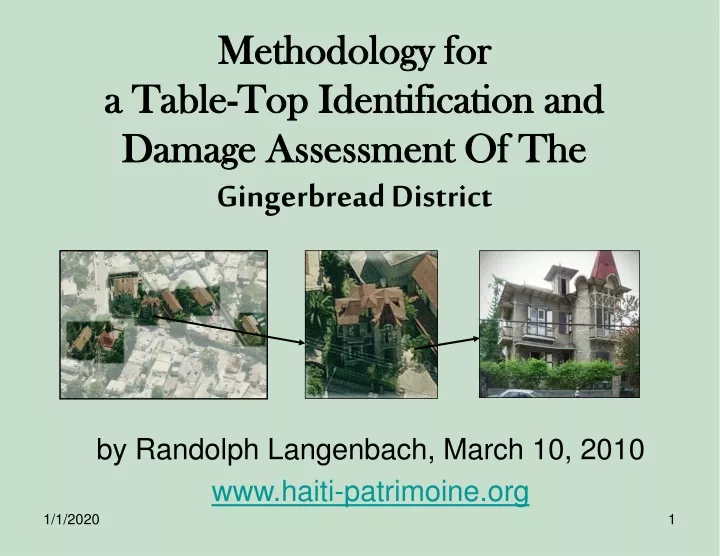
Methodology fora Table-Top Identification and Damage Assessment Of TheGingerbread District by Randolph Langenbach, March 10, 2010 www.haiti-patrimoine.org
The Methodology First, a superblock size area from GINGERBREAD DISTRICT is selected for the survey. All of the aerial photography illustrated here has been produced by Pictometry Corporation, Rochester New York, and the use of it by ICOMOS has been generously granted by:
In Photoshop, the Gingerbread houses are Identified from the one of the four oblique views, and corroborated on the others.
This shows how they can be picked out of a congested area that is remote from the main city streets.
Here are two examples of buildings that may have been gingerbread houses that are in ruinous condition. The one on the RIGHT probably collapsed in the earthquake, while the one on the left was probably being demolished at the time of the earthquake. Both appear to have been masonry structures.
The Pacot and Bois Verna sections of the Gingerbread District – all in one single mosaic image. Above: One single image extracted from Pictometry Online. Above: The mosaic of 12 separate Pictometry images. Right: The oblique view of the Gingerbread district from the North. Next Page: The view of the same area from the South. One of the important discoveries with the use of the Pictometry imagery, is that they can be successfully merged into a single mosaic using Adobe Photoshop’s “Photomerge” feature.
The following pages show one superblock area with the Gingerbread houses identified. This is the area to the east side of Avenue Ch. Sumner.
Large house in poor repair, but which survived. Collapsed house Colombage (“pan-de-bois”) construction visible House where modern (perhaps hotel?) addition collapsed, while house survived. View from the South of area to east of Avenue Ch.Sumner House with Colombage top story of colombage construction, with unreinforced masonry below. This house was recognized as the same as in the photograph taken by Conor Bohan after the earthquake. Photo by Conor Bohan for the WMF
Photo by Conor Bohan for the WMF Area east of Ave Ch. Sumner viewed from the NORTH. The check survey from the North orientation revealed the lightly damaged colombage (“pan-de-bois”) construction house photographed after the earthquake by Conor Bohan. This house is among a nice cluster of Gingerbread houses as can be seen by the group on the left.
This view shows the other side of the house photographed by Conor Bohan shown on the South view. This shows a good cluster of such houses surrounded by trees. The view on the left shows a surviving house next to a modern wing (or neighboring structure) of concrete construction that collapsed. Area east of Ave Ch. Sumner viewed from the EAST.
Another section of the view from the east shows a cluster of Gingerbread houses that, in contrast to the ones with trees around them, have been tightly surrounded by later construction.
Area east of Ave Ch. Sumner viewed from the WEST. Notice that there is a Gingerbread house partially hidden by large modern structure.
This shows the identified houses marked onto the straight-down view so as to create an accurate map. The oblique views of each house can then also be inserted into an excel-style formatted database where the other information about each property can be filled in. Area east of Ave Ch. Sumner in PLAN view (straight down).