Download
1 / 15
170 likes | 343 Views
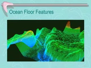
Ocean Floor Exploration. HMS Challenger (1872-1876). The old method of data collection to map the ocean floor used lead weights and rope. SONAR (Echo Sounder). SO und N avigation A nd R anging Began use in 1925 Helped submarines in WWII. Satellites.

E N D
HMS Challenger (1872-1876) • The old method of data collection to map the ocean floor used lead weights and rope.
SONAR (Echo Sounder) • SOund Navigation And Ranging • Began use in 1925 • Helped submarines in WWII
Satellites • In the 1970s, orbiting satellites began to collect ocean data • This method proved to be much faster
Seasat • launched in 1978 • measures direction & speed of ocean currents
Underwater Submersibles • Ex. of piloted vessels: The Alvin and Deep Flight • Ex. of robotic vessels: JASON II and Medea (both are tethered together)
Jason II (ocean floor) Medea (ocean surface)
Deep Flight Submersible **Actually classified as an underwater airplane.