Download
1 / 1
10 likes | 80 Views
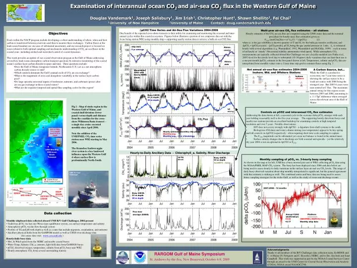
DEEP BASIN. INNER. MID-SHELF. JEFFREY’S LEDGE. UNH R/V Gulf Challenger. Kennebec- Androscoggin Rivers. Portland ME. UNH & PMEL CO2 coastal buoy at 65 m depth. WB2. Portsmouth NH. WB7. UNH Monthly Wilkinson Basin Transect. Merrimack River. Boston MA.

E N D
DEEP BASIN INNER MID-SHELF JEFFREY’S LEDGE UNH R/V Gulf Challenger Kennebec- Androscoggin Rivers Portland ME UNH & PMEL CO2 coastal buoy at 65 m depth WB2 Portsmouth NH WB7 UNH Monthly Wilkinson Basin Transect Merrimack River Boston MA Monthly sampling of pCO2 vs. 3-hourly buoy sampling As shown on the map at far left, UNH has a buoy moored just east of WB2 collecting pCO2 data using the NOAA/PMEL MAP-CO2 system. The buoy has been deployed since 2006 and data below are being used to assess hourly to daily variations in the surface layer air and sea CO2 levels. The range of daily buoy-observed variation about ship monthly-interpolated is significant, but the general agreement with that estimate is striking as well. The combined cruise and buoy data are being used to assess future sampling strategies for the wider Gulf, as well as the study of storm and discharge events. Coastal Buoys NDBC/GoMOOS/UNH WB2 WB7 Weiss-equilibrator Flo-thru oxygen, IOPs and CTD 2007-2008 - 12 months Annual FCO2 Platform (molC/m2/yr) ---------------- +0.02 UNH/PMEL MAPCO2 buoy +0.17 Monthly ship data Examination of interannual ocean CO2 and air-sea CO2 flux in the Western Gulf of MaineDouglas Vandemark1, Joseph Salisbury1, Jim Irish1, Christopher Hunt1, Shawn Shellito1, Fei Chai21University of New Hampshire 2University of Maine Contact: doug.vandemark@unh.edu ΔpCO2 Time Series and Air-Sea Flux Variations 2004-2008 One benefit of the repeated cross-shore transects is their utility for examining and monitoring the seasonal and inter- annual cycles within this coastal ecosystem. Figures below illustrate a portion of our composite data set with the focus being station WB2 using monthly ship + supporting nearby station data to retrieve a bulk air-sea CO2 flux. Multi-year air-sea CO2 flux estimates – all stations Hourly estimates of the CO2 air-sea flux are computed using the UNH cruise data and the nominal procedure for hourly mass flux estimation given as: FCO2 (molC/m2/hr) = α* kw(U) * (ΔpCO2) (1) where α is the gas solubility (a known quantity of T and S), kw the bulk gas transfer coefficient, and ΔpCO2 = [pCO2seaside] – [pCO2airside], pCO2 being the gas’ partial pressure at 1 atm. kw is estimated hourly with several algorithms (e.g. Wanninkhof, 1992; Wanninkhof and McGillis, 1999) – each in terms of an hourly or ‘steady’ 10m neutral stability anemometer wind speed. While atmospheric CO2 measurements are typically collected aboard the Challenger we use a locally-modeled (see Padin et al., 2007) level for the airside level due to substantial (10-30 ppmv) daily variations that can limit their use is a one-per-month ΔpCO2 estimate in the first panel shown at left. Temperature, salinity and pCO2 data are interpolated from monthly values onto a 1 hour time step grid to estimate fluxes using Eq. 1. • Objectives • Goals within the NACP program include developing a robust understanding of where, when and how carbon is transferred between reservoirs and then to monitor these exchanges. Carbon fluxes at the land-ocean boundary are one area of substantial uncertainty, and our research project is focused on issues related to both optimal sampling and mechanistic understanding of CO2 air-sea fluxes in the coastal zone- including airshed and watershed control of coastal dynamics. • This work provides an update of our coastal observation program in the Gulf of Maine addressing several key land-ocean-atmosphere carbon transport questions by intensive monitoring of the coastal ocean’s surface layer carbon dioxide in space and time. These questions include: • Does the Gulf of Maine (temperate latitude, Northeastern U.S.) act as a net atmospheric carbon dioxide source or sink? • Which controls dominate the Gulf’s annual cycle of CO2 air-sea exchange? • What is the magnitude of cross and alongshore variability in the surface layer carbon pool? • Do large episodic terrestrial inputs of freshwater, nutrients, and carbonate species alter air-sea gas exchange in these coastal waters? • What are the requisite temporal and spatial flux sampling scales for this region? ship data 5 yr average Atmos. source Atmos. sink Net annual air-sea flux estimates 2004-2008 Inshore, Mid, and Offshore Stations A Carbon Source, but… While the Gulf is a productive ecosystem, our 5 year time series is showing the surface waters to be a weak net source with 2004 being the strongest year. But 2005-6 years were near neutral in C flux. The maximum annual swing for this region occurs between 2005 and 2004, amounting to a -1.1 TgC difference when averaged across the relevant area of the Gulf of Maine. Wanninkhof 1992 with hourly NDBC winds inshore offshore Buoy 44030- 01 m depth 50 m depth Fig 1 - Map of study region in the Western Gulf of Maine, and coastal shelf divisions (lower panel) versus depth and distance from the coastline for the cross-shore Wilkinson Basin transect – a single day cruise executed monthly since April 2004. Note the addition of the UNH/PMEL CO2 time series station near WB2 starting in May 2006. The Kennebec/Androscoggin river system is a key landward influence upon the Western Gulf 4 where surface flow is predominantly North-South. • Controls on pCO2 and interannual CO2 flux estimates • Addressing the data shown at left, a seasonal cycle in the seawater delta pCO2 emerges with each year holding reasonably well to the five year average. The supporting hourly data from buoys and nearby met stations provide an excellent backdrop for examining controls at high temporal resolution and over 5 years. Notable observations: • SST does not covary strongly with ΔpCO2 - a departure from shelf systems to the south • Biology(see Chl data) and water column mixing (see temperature) appear to be key spring and fall controls on ΔpCO2 respectively - often requiring short time scale sampling to capture • The FCO2 magnitude can be substantial yet a near net balance is found in the annual mean • Surface salinity changes due to discharge are both seasonal and episodic - yet the relatively dry year 2004 is not exceptional in ΔpCO2 or FCO2 fall mixing CO2 Flux 44007 Hourly estimate (monthly ship pCo2) Monthly avg. Monthly avg., ~5 yr climatology 44030 IOSN3 Hourly-to-Daily Ancillary Data - Chlorophyll_a, Salinity, River Discharge spring bloom Buoy 44030 - 03 m depth SeaWiFS - daily Buoy 44030- 01 m depth 50 m depth Five river average (USGS) • Data collection • Monthly shipboard data collected aboard UNH R/V Gulf Challenger, 2004-present • Underway pCO2 via fast-rate Weiss-type equilibrator system, sea surface temperature and salinity • Atmospheric pCO2 via the flow through system • Profiles of TA and pH with depth as well as a suite that include pigments, zooplankton, and nutrients • Ancillary physical fields from the GoMPOM model as well as USGS river discharge data • (for cruise data visit: www.cooa.unh.edu ) • Hourly/daily buoy data • Met. & Wind speed from the NDBC and nearby coastal buoys • Water Temp, Salinity, Chl_a, currents, light field data from GoMOOS buoys • pCO2, dissolved oxygen, temperature, salinity from pCO2 buoy near WB2 • Hourly atmospheric CO2 from several surrounding stations Acknowledgments Thanks to all members of the R/V Challenger data collection team, GoMOOS and U. of Maine (N. Pettigrew and C. Roessler), NDBC, and to Drs. Jim Irish and Janet Campbell. This work was supported in part by the NOAA Coastal Services Center through an award to the UNH Center for Coastal Ocean Observation and Analysis (COOA); NOAA award NA16OC2740. RARGOM Gulf of Maine Symposium St. Andrews-by-the-Sea, New Brunswick October 4-9, 2009