Download
1 / 17
180 likes | 294 Views
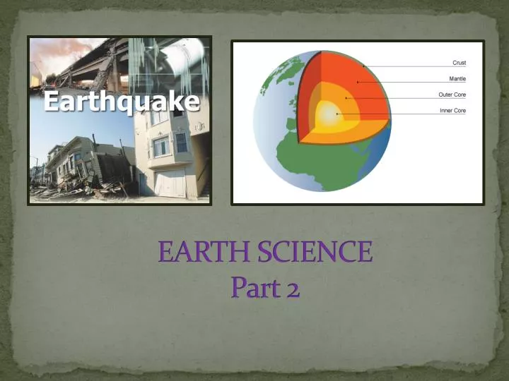
EARTH SCIENCE Part 2. Continental Drift. Earth’s Structure. 1- CRUST- Is the first layer of the Earth. It’s made of solid rock that is the Earth’s outermost layer. Very thin layer. 8 to 32 km (5-20 miles).

E N D
Earth’s Structure 1- CRUST- Is the first layer of the Earth. It’s made of solid rock that is the Earth’s outermost layer. Very thin layer. 8 to 32 km (5-20 miles) 2- MANTLE- Is the second layer of the Earth. It’s made of molten rock. The rocks move very slowly and have high temperatures. 2,900 km (1,800 miles) 3- OUTER CORE- Made of melted iron and is a liquid layer. 2,250 km (1,400 miles) 4- INNER CORE- It is very hard and thick like a ball. It’s located at the Earth’s Center. Very solid material. 1,300 km (800 miles)
former “supercontinent” on the Earth included all present continents, which broke up and drifted apart Pangaea This is the map of Pangaea. This was the world 225 million years ago. This is the map of the world now !
Plates Tectonic (Continental Drift) • Tectonic Plates is where there are 2 sub layers of earth’s crust, which can move or float that can causes Continental Drift, Earthquakes, or Volcanoes • Plates can move in 4 different directions during earthquake (push apart, pull apart, slide side to side, or up and down). • There are 15 tectonic plates When the two tectonic plates collides with each other, the continental crust buckles and rocks pile up Where the tectonic plates spread apart and creates earthquake
Volcano information • Volcanoes usually erupt after giving some type of warnings: gas rising, small quakes, cracks on the surface, magma rises • The longer the lava takes to set, the smoother it is. The shorter time it takes, the more holes it has in it. RinG OF FIRE The “Ring of Fire” is a group of 450 active volcanoes located along the edge of the Pacific Ocean. Most volcanoes are right where the faults are.
“Tilt-o-meter” A “tilt-o-meter” is a tool to measure ground movement. The tool is used by volcanologist to warn the public of seismic activity and a possible volcano.
Earth’s Structure MAGMA- mixture of molten or semi-molten that can be found beneath the Earth’s surface • LAVA- hot molten that erupted from a volcano; liquid rock that has reached the surface
Seiche Effect • The Seiche Effect is when the waves move out towards the ocean before a wave hits • Is a tool that measures tsunami
Tsunami Information • Tsunami is a Japanese word for a giant wave caused by an earthquake • Tsunami waves travel at around 600 miles per hour! • A tsunami wave can be as much as 130 feet tall! • If a tsunami is coming: MOVE TO HIGHER GROUND! Refraction is the bending of a wave around a corner
Earthquakes Earthquakes
Seismograph • Records and detects and measures Earth’s movement • Is an instrument to measure the magnitude of an Earthquake • Printed record is called a seismogram
Earthquake • Are movements or vibrations in Earth • Caused by release of stored energy in Earth’s outer layer. • Earthquakes are caused by faults • The point on a fault line where a plate moves is the focus
Earthquake con’t • Epicenter is the point directly above the focus on the surface of the Earth • In order to locate the epicenter, Scientists have to use 3 locations (triangulation) of earthquake readings.
Richter Scale The Richter scale measures the magnitude of the earthquake.