Download
1 / 40
400 likes | 584 Views
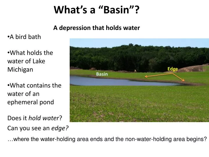
What’s a “Basin”? A depression that holds water. A bird bath What holds the water of Lake Michigan What contains the water of an ephemeral pond Does it hold water ? Can you see an edge?. Edge. Basin. …where the water-holding area ends and the non-water-holding area begins?.

E N D
What’s a “Basin”?A depression that holds water A bird bath What holds the water of Lake Michigan What contains the water of an ephemeral pond Does it hold water? Can you see an edge? Edge Basin …where the water-holding area ends and the non-water-holding area begins?
Where’s the edge? Where the water ends when the basin is full . . . Easier to see in spring or after heavy rain. April 18 Where the plants haven’t grown or are stunted because the soil was flooded for awhile August 14
Where’s the edge? In shaded pond, where the vegetation type changes . . . often to dense carpets of nettles or jewelweed Where there’s a break in the slope
Not every PEP is a Basin This pile of dark colored rocks was mistaken for ponded water on the aerial photo and mapped as a PEP
Not every PEP is a Basin No sign of a Basin here in 2008. The aerial photo used to map PEPs was taken in 2005. Perhaps the lone large tree in the field was mistaken for a small pond?
Not Every Basin is an Ephemeral Pond Too small? The size of a picnic table. Most EPs are larger than a bedroom. Too shallow? This PEP was only a few inches deep in April after lots of rain.
Not Every Basin is an Ephemeral Pond No sign of water, even in early spring Water lilies indicate the pond is permanent
Why we need to visit more than once In April 4-ft deep, but dry by fall Still deep in October, receives storm water runoff all summer
Typical Ephemeral Pond Basin holds water long enough to support some aquatic organisms Dries out by summer or fall in most years When full, the water depth is usually less than 4 feet but more than 6 inches. • Most are less than an acre (200 ft x 200 ft)
In the Woods or in the Open One of the smallest . . . About 30 feet x 100 ft Small, but big enough to attract a flock of waterfowl
What if there’s no Pond Basin? • Check that you’re in the right place • If its obviously not a Basin, mark “no” and use comment line to tell us what it is • Take a photo to document – our mappers want to know what fooled them • If you’re not sure go on and complete the form
Is the Basin Connected to another water feature? This Basin might be connected to a small stream What looks like 1 Basin in April may turn out to be 2 Basins by July
Is Basin Connected to Another Water Feature? One pool or multiple pools?: • as pond draws down, multiple pools may form. • use best judgment at lower size limit (i.e., don’t include boot prints)
Is the Basin Connected to another Water Feature? • Check for: • connection between other pond basins • comment on any relationship
Pond Within a Floodplain Swamp Find picture of ephemeral pond in marsh
Pacing Out Basin Dimensions Basin Full of Water Dry Basin Width Length Length Width Pace parallel to water’s edge at first visit in early spring Pace through formerly ponded area after pond dries out
Pacing Out Irregular Basin Dimensions • Guesstimate to average out the irregularities • Aim for getting area about right • Sketch it out if you want • Don’t sweat it! (we don’t pay by the square foot) Length Width
Signs of high water The swollen base of this trunk is a response to low oxygen during flooding Water marks on nearby trees are always at the same elevation
Water Depth and Maximum Water Depth Measure Water Depth each visit! at the deepest point …safely …or estimate Notice the high water marks on the trees Maximum Water Depth is as deep as the pond gets. Usually the same as Water Depth in very early spring.
Measuring Maximum Water Depth Measure “Water Depth” (blue line) at deepest point Find high water mark on tree standing in water Measure vertical distance from the water surface to high-water mark indicator (brown line). Add together for Maximum Water Depth. Max Water Depth = Water Depth + Distance from Water to High Water Mark Highest Water Level (Previous) High Water Mark on tree Current Water Surface Water Depth Distance from Water Surface to High Water Mark
Estimating High Water Depth • When the current water level is below the base of any indicator tree, or there are no trees, then get your best estimate with an “indirect measure”. Like with Water Depth, approximate is fine. An estimate within a half foot is still helpful
Surface water covering the basin? Less than 10% . . . hardly any water left 10 to 50% . . . some water but lots of the basin exposed
Water Temperature: • measure at deepest point 3-5cm from bottom • let thermometer stabilize for 1 minute • estimate to nearest degree
Pond #12 at MNP May 24 October 18
Basin Disturbance • Filling • Refuse • Tire Ruts • Sediment • Cultivation • Invasive Plants
Test Time . . . Edge, Depth, Ground Cover, Trees in the Basin?