Download

1 / 41
460 likes | 966 Views
Grid generation for SCHISM with SMS Joseph Zhang, VIMS Eli Ateljevich , DWR. The good news and bad news. Bad news UG grid generation is often a laborious and iterative process Steepest part of the learning curve for UG models

E N D
Grid generation for SCHISM with SMSJoseph Zhang, VIMSEli Ateljevich, DWR
The good news and bad news • Bad news • UG grid generation is often a laborious and iterative process • Steepest part of the learning curve for UG models • This is especially true for very large grids: a common source of frustration with SMS – build confidence gradually and do it in stages • Good news • SCHISM is not picky about grid quality; it won’t blow up easily • Once you master the G.G., the rest of the model setup is more straightforward • A few ways to blow up the model • Bad quality quads (backtracking error): split them to get pair of triangles if you are not sure • Completely blocking the water flow, e.g., by under-resolving the main channel • Dry open boundary: a few ways around this (there is now a branch that handles this) • Momentum dissipation too low (parameter choice): dissipation is essential part of non-eddying regime
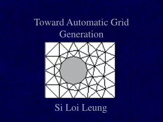
Overview of The GG process • Know your domain and target physics • Understand SCHISM numerics • Usually it’s easy to get ‘reasonable’ results without much effort • You cannot take full advantage of SCHISM features unless you understand inner working of its physics and numerics • Elevation and contour data preparation • Digitize or determine boundary (ideally as shape files from ArcGIS) • Import and refine conceptual model • Identify critical features/contours • Identify resolution/density • Create polygons and patch/pave locations • Generate the mesh • Populate mesh elevations (depths): no smoothing • Mesh quality and bathymetric metrics: important for eddying regime • Performance and accuracy metrics: transport solvers are often the main bottleneck • Clip mesh as necessary for subdomains of interest • Concatenate/splice meshes More physics, less numerics
General rules • Unlike explicit models, you’ll find G.G. for SCHISM is more ‘intuitive’ and ‘freer’ • Implicit model allows you to focus on physics instead of numerics (CFL…) • You are freer to resolve important features without worrying about cost/instability • SCHISM is not picky about grid quality (except for quads); however, grid quality pays off for accuracy especially in some critical regions • G.G. for baroclinic applications requires more effort (often an iterative process): establishing a good workflow is essential • Grid needs to be smooth in eddying and transitional regimes, in order to not distort eddy kinetics (Wang and Danilov 2016)
SMS Conceptual Model • Nodes, vertices, arcs and polygons • The basic meshing unit is (closed) polygon • Dangling arcs sometimes cause crash • Feature nodes may lead to skew elements
DEM preparation: pre-filtering bathymetry • Unresolved subgrid features may be eliminated • eliminates lunar landscape undulations on mudflats • level set or active contour methods (e.g. Malladi and Sethian): contours conservatively straighten • California DWR has python code smooth_contour.py for small regions • This is more for assisting in the arc creation than for actual interpolation of depths • ArcGIS has many tools for arc preparation • Output as shape files and import into SMS • Can also clip, clean, and manipulate arcs (e.g. min distance)
Liberty Island Smoothing: Malladi and Sethian Min-max curvature flow
Magic Contours • Foot/top of slope, thalweg • High-gradient zone in DEM for ‘features’ • Shoreline and probable “real” water levels • Important for wet/dry; always grid ‘conservatively’ to account for interpolation ‘error’ (e.g., use 0.5m instead of 0m, or use ArcGIS to shift a distance away from the actual isobath) • Flooding and mudflats: may need an estimate of surface elevation, or just resolve well • Key features (jetty, breakwater…) • TVD (h_tvd) and other algorithm switches • Depths used in friction and other user threshold choices
Tidal range Shoal Channel Ship channel Skew elements h_tvd = 5m, Water elev ~ 0.5m so -4.0 NAVD contour mostly non-TVD
Choose Connected Contours • SMS works best with closed polygons • If you have to use ‘hanging arcs’, you may consider improving grid quality a little afterwards (e.g. xmgredit has spring) Well resolved without help Changing from -2 to -3m increases connectivity No need to be religious about following contours exactly
Stick with the center Follows inner channel without help Inner channel delineated Ignores inner channel
Grid Density • Need guidance from inverse CFL>0.4 • Start from a smallest expected Dt (e.g., 100s) • Use CFL>0.4 to back calculate the coarsestDx at a given depth • Deeper regions generally coarser than shallows but not always (compare this with explicit models that are constrained by CFL) • Often channel needs to be resolved for tracer transport • Curvature should be resolved: • 2D: bend in shorelines • 3D: changes in slope (vertical grid plays a role) • Width of features (sills, beaches, channels) • Skeletonization algorithms (see Per-OlofPersson dissertation)
Grid resolution Guide Dt=100s (expected minimum*) • Remember to refine grid if for some reason you have to reduce Dt • Small patches of violation is fine especially near shoreline; avoid it in large open area
Wetting and Drying • Element-based designation • Based on node elevations • All 3|4 wet => wet element • No partial wet/dry • Velocities calculated on edges of wet elements
Always wet Clogged Clogged or narrow Robust!! Mildly inaccurate: wrong contour? • With SCHISM you can faithfully represent channels (and other features), thru good choices of horizontal and vertical grids • In estuarine and near-shore applications, faithful representation of bathymetry and features is the right approach, as opposed to artificial manipulation of bathymetry
Patching and Paving • Newer versions of SMS are more forgiving with patches • Remember to check quality for quads in gredit5 (otherwise you may get an error from backtracking..) Pave Patch
Patch vs Pave • Pave: • Recommended for quality grids on large, well-resolved water bodies • Works well when polygon is big and wide compared to arc nodes • Most robust of all methods • Resolution harder to control in the interior • Patch • Usually used for channels or other regularly shaped structures • Gives you better control on interior resolution
Hydraulic Structures Q Faces 1 2 1 1’ 2 2’ 3 3’ 4 4’ 1-1’ etc are node pairs 5 5’ “Block” Patches are natural choices here…
Dovetailing Patch and Pave* *These ideas not unique to patch/pave *Note the change in effective resolution…
Populating Elevations • Big problem again … SMS doesn’t hold the data gracefully • Have heard of people doing it in stages • Can use stacked_dem_fill.py, which: • Populates with correct georeference • Matches contours • Uses prioritized DEMs • Gives some warnings • We have FORTRAN scripts for loading very large TIN (UG) or raster DEMs • We always use linear interpolation (consistent with SCHISM’s shape function), without any smoothing • You should really visualize the bathymetry immediately after G.G.; correct mistakes (e.g. blocked channels) immediately
Metrics • Volumetric error (actually, average height) • Patterns can be systematic • This can be significant in minor channels: ‘greedy gridding’ • Face/edge aperture or area • Storage area • Skew: SCHISM very tolerant, but good to look (if you use xmgredit5, try skewness of 14) • Need to use quality quads (xmgredit5: angle ratio >0.5) • Area change: SCHISM very tolerant, but good to look • Slope: PGE issue usually not a problem (vgrid and parameterization play a role also) • Local error: Richardson extrapolation • Painful without tools • TVD2 and sub-cycling measures (fort.17; dtbeoutputs): less of a problem with TVD2 • Eddying regime requires more uniform and higher-quality grid to avoid distortion of eddy dynamics • CFL (>0.4) • Xmgredit5 can easily check CFL for you • Dimensionless wave number may also need to be looked at
TVD tuning • (Vertically) implicit TVD2alleviated much of the pain • There is also a “hidden” dtbe visualization option (USE_ANALYSIS) which you can use to find subcycling ‘hot spots’ • As a rule of thumb, transport time step of 5-10s range is reasonable
Common Ad Hoc Fixup Steps • Deepening of boundary depths to prevent open boundary from becoming dry • There is a fancier approach to preserve the original depth using bed deformation module or point sources In gredit, create a region and depth=max(depth,3)
Gridding shallow systems Hangzhou Bay Qiantang River
Qiantang River Big portion of the river is above MSL!
Gridding strategy • From observation we know that the channel rarely dries up, as the surface elevation is 1-2m above the bottom • In the model setup, we can specify a non-zero i.c. for elev; e.g. we know from observation that the elevation in the upper most stretch of river is ~3m above MSL, so we can use h=3.2m everywhere as elev.ic (including the ocean part) • Then we gradually ramp down the elev toward h=0 at the ocean boundary • System response is barotopic and fast • Set nramp_elev=1 so the model will ramp down from elev.ic • During gridding, capture the ‘below MSL’ portion of the channel in the lower part of the river first • Be game in resolving narrow channel! • In the upper stretches where the bottom is mostly above MSL, it’s up to you whether to skip the details of bathymetry during gridding • At the river inflow boundary, you may dredge a small region to let water come in. The model will set up the surface slope automatically
Gridding strategy Lower river: channel can be delineated patches patches paving paving Don’t be timid in resolving the narrow channel! (Actually the model may misbehave without this) Upper river: your choice (but try to resolve)
River inflow boundary * Alternatively, use point sources Dredged area
Bridge piling • ~1800 bridge pilings in lower Chesapeake Bay, 1-2m in diameter • Used ArcGIS to export shape files for all pilings into SMS • Time step of 120s (efficiency) Liu et al. (Ocean Dynamics 2018)
Marsh • Marshes need super high resolution (~1m) • Use ArcGIS to generate ‘marsh points’ • Import into SMS as feature nodes • Set a very small tolerance (1.e-6m) • Skew elements are generated, which is fine with the model (including WWM, SED3D)
Coupling to watershed model: the Delaware Bay case • Coupling SCHISM to National Water Model (NWM) for compound flooding problems • Need to resolve small creeks to facilitate water delivery from NWM • Inject flow at all intersections between NWM segments and SCHISM’s boundary Segments that intersect the land boundary NWM segments SCHISM boundary
Combine shapefiles and the grid boundary (@-10m) into a single map • Add main shipping channel that is missing from NWM Exterior boundary (10m above MSL) NWM shapefile Grid Generation for DE Bay = +
Some skew elements are generated because some arcs are close to each other • We can leave them as they are (SCHISM can handle) or use our tools to smooth out the transition a little (without touching the main channel) • Aligning main channels manually – this took a few hours only • This ensures accuracy and proper propagation of tides into the estuaries Final grid
Extend to larger extent (US east coast) • Workflow • Extract domain exterior boundary (@-10m) • Extract shoreline • Form polygons between (1) and (2); optionally leave a buffer between polygons • In ArcGIS, clip NWM segments that are outside the polygon • Manually add major channels • Best to do in stages, one estuary at a time to make steady progress boundary shoreline
Eddying regime • Eddying regime prefers quasi-uniform grid (bathymetry variation in deep ocean is mostly negligible) • Most challenging part is near steep shelf breaks • Always start from quasi-uniform grid and then adjust as needed
Caribbean islands Non-eddying regime (shallow) Use arcs to separate the non-eddying regime and the eddying regime: Make sure the elements inside the eddying regime are nearly uniform; Keep sharp transitions of element size inside the non-eddying regime The very steep slopes require additional momentum dissipation Eddying regime (deep) Non-eddying regime (shallow)
Bad grid Size transition inside the eddying regime, which can distort meso-scale eddies and lead to unpredictable behaviors. Unnecessary arc * Need to delineate different regimes
Spurious upwelling on a bad grid (this type of spurious upwelling is persistent and easy to spot)
Good grid Sharp transitions of element size only in the non-eddying regime Mark the boundaries between 2 regimes (even though they are close)
Conclusions • SMS is an adequate tool for non-orthogonal grids used by SCHISM • Good grid generation resolves flow/bathy features faithfully • Some finer scales ignored if not resolved • Implicit FE model provides you with more freedom for resolution • Shape functions and wet-dry rules; understand the physics and numerics! • You can’t work on this stuff unless you can fix-test-fix-test • So front-end on node-based inputs (see BayDeltaSCHISM) • IMPORTANT: always start from an estimate of smallest Dt you anticipate for the application and use CFL>0.4 to back-calculate the coarsest resolution at each depth • If you somehow decide to reduce Dt later, you may have to refine the grid • As a rough guide, Dt=100-450s for b-tropic, 100-200s for b-clinic applications (however, smaller Dt might be needed for some extreme cases)
Conclusions (cont’d) • For shallow-water systems, resolve the channels (even if they are narrow) • Gridding upstream requires some understanding of how the model deals wet/dry (parameterization is important) • For eddying and transitional regimes, vary resolution gradually; delineate the boundaries with non-eddying regime • Skew elements are fine in non-eddying regime