Download
1 / 32
390 likes | 807 Views
Soil Physical Properties Used to Assess Soil Quality. Field Exercise. Two Ways to Assess Soil Quality. Measurements over time. Comparing management systems. Examples: Side-by-side comparisons of management systems. Measurements in the same field over time.

E N D
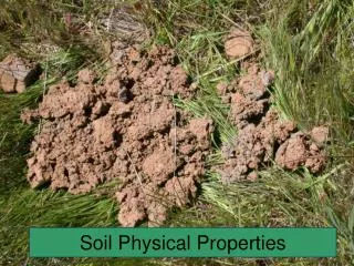
Soil Physical Properties Used to Assess Soil Quality Field Exercise
Two Ways to Assess Soil Quality • Measurements over time. • Comparing management systems. Examples: • Side-by-side comparisons of management systems. • Measurements in the same field over time. • Problem areas versus non-problem areas. • Compare measured values to a reference soil condition or to the natural ecosystem.
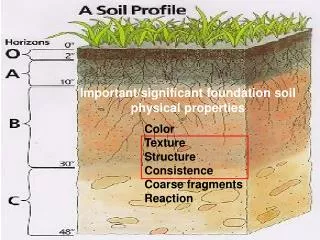
Physical Property: Bulk Density Porosity Macroporosity Microporosity Air-Filled Porosity Air-Filled Porosity Hydraulic Conductivity Field Capacity Plant Available Water Aggregate Stability Infiltration Penetration Resistance Condition: Compaction Aeration Percolation Infiltration Drainage Aggregation Waterlogging Erodibility Crusting Root Growth Plant Growth Soil quality is assessed by measuring a number of soil properties to evaluate the soil’s ability to perform basic functions.
Bulk Density • The ratio of oven-dried soil (mass) to its bulk volume (g/cm3). • Range: 1.0 to 1.7 g/cm3. • Used to convert soil water content in percent by weight to percent by volume. • Used to calculate porosity. • Calculation: BD = Oven-Dry Soil Weight/Core Sample Volume • Indicator of: Compaction, aeration, root growth, microbial activity, infiltration, and drainage.
Porosity • That portion (%) of the soil not occupied by solid material. • The ratio of the soil pore volume to its bulk volume. • Calculation: Porosity (%) = 100 – 100(BD/PD) where, PD = Particle density. • Indicator: Compaction, aeration, aggregation, root growth, microbial activity, water movement and storage.
Macroporosity • That portion (%) of the soil occupied by pores of large size. Because of their large size, they are not able to retain water against gravity by capillary action. • The ratio of large pore volume to the soil bulk volume. • Calculation: % Water by volume at saturation - % Water by volume at field capacity. • Indicator: Compaction, aeration, aggregation, root growth, microbial activity, water movement and storage.
Microporosity • That portion (%) of the soil occupied by pores of small size –also called capillary pores. Because of their small size, they are able to retain water against gravity by capillary action. • The ratio of small pore volume to the soil bulk volume. • Calculation: % Total Porosity - % Macroporosity. Indicator: Compaction, aeration, aggregation, root growth, microbial activity, water movement and storage.
Air-Filled Porosity • That portion (%) of the soil occupied by air-filled pores. • The ratio of air-filled pore volume to the soil bulk volume. • Calculation: % Water by Volume at Saturation - % Water by Volume at Sampling. Indicator: Aeration, excessively wet conditions, microbial activity, drainage.
Saturated Hydraulic Conductivity • Indicator of the soil ability to conduct water (in/hr) in saturated conditions. • The ratio of the flow density or “flux” per unit hydraulic gradient. • Estimation: Soil Water Characteristics Calculator (http://www.pedosphere.com/resources/texture/triangle_us.cfm • Indicator: Water movement, compaction, aggregation.
Field Capacity • The water content (in/ft) of soil after free drainage from a saturated condition. • The amount of water (in/ft) that a soil is able to retain after free drainage. • Calculation: (% Water Content by Volume)/100 x (12in/ft). Indicator: Water retention, plant growth, rooting, microbial activity, compaction, aggregation.
Permanent Wilting Point • The water content (in/ft) below which plants are generally unable to extract water from the soil. • Calculation: (% Water Content by Volume)/100 x (12in/ft). • Estimation: Soil Water Characteristics Calculator (http://www.pedosphere.com/resources/texture/triangle_us.cfm).
Plant Available Water Holding Capacity • The quantity of water (in/ft) that a plant is able to extract from a soil at field capacity. • Calculation: Field Capacity (in/ft) – Permanent Wilting Point (in/ft). • Indicator: Available water retention, plant growth, rooting, microbial activity, compaction, aggregation.
Water Stable Aggregates (Aggregate Stability) • Measures the amount of stable aggregates (%) against flowing water. • Calculation: % Water Stable Aggregates = 100 [(Weight of Stable Aggregates)/(Weight of Aggregate Sample Used)]. • Indicator: Soil erodibility.
Infiltration • The entry of water into the soil (in/hr). • The height (in) of water entering the soil surface per unit time (hr). • Calculation: Water Height (in)/Time (hr). • Indicator: Water runoff, erosion.
Penetration Resistance(Soil Strength) • Soil resistance (kg/cm2) to penetration by a metal rod. • Calculation: Cone Index = force applied (kg)/cone tip basal area (cm2). • Indicator: Compaction, root proliferation, infiltration, drainage, microbial activity.
Measurement of Soil Physical Properties for Soil Quality Assessment
Question 1:Based on the soil water content obtained from the core sample, determine the depth of water (inches) needed so that the upper foot of soil reaches field capacity.Conventional Tillage:Water Content at Sampling= 20.6% or 2.47 in/ftField Capacity = 3.1 in/ftAnswer: 3.1 – 2.47 = 0.63 in/ftStrip Tillage:Water Content at Sampling= 32.2% or 3.86 in/ftField Capacity = 3.5 in/ftAnswer: 0 in/ft
Question 2:Calculate the soil water content (in/ft) at 50% plant available water depletion. Next, calculate how much water (inches) needs to be added to the upper foot of soil to reach field capacity.Conventional Tillage:Soil Water Content @ 50% Depletion = PAW/2 + PWP = (1.6/2) + 1.5 = 2.3 in/ft (19.1 %)To reach FC add the amount depleted = 1.6/2 = 0.8 inches
Question 3:Use the soil water characteristic calculator to estimate the soil properties listed below. Compare the estimations with the results obtained from your samples.
Question 4:Using the soil water characteristic calculator determine the effect of a two-fold increase in organic matter in each soil environment. Any improvements?