Download
1 / 68
690 likes | 750 Views
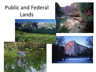
Federal Lands. The Production Spectrum. Information – statistics, public records. The Production Spectrum. Information – statistics, public records. The Production Spectrum. Information – statistics, public records.

E N D
The Production Spectrum Information – statistics, public records
The Production Spectrum Information – statistics, public records
The Production Spectrum Information – statistics, public records
Governments Influence the Production of All Goods and the Provision of All Services • Public • Private • Under coercion • Regulation • Financial Incentive – taxation, loan, infrastructure construction (water treatments, sewers, roads) • Usable/Accessible information • 2. Without any coercion – “free market” • There ain’t no such thing as a free lunch Information – statistics, public records
The Dynamic of Public and Private Lands • Public lands and private lands represent the ends of a spectrum that describe how goods are produced and how services are provided • Decisions about public lands are reflected in the decisions about private lands • Goods produced from the public lands and the services provided by public lands represent the outcome of several debates about the role and responsibility of government • Rarely does a session of Congress not enact legislation, either to convey or to acquire title to a parcel of land
Paradigm for Public Lands • Public lands are not historical accidents • They represent the outcomes of decisions that we have collectively made to produce goods and provide services from land owned by government rather than privately owned lands • Federal lands reflect decisions to produce goods and provide services from lands owned by the federal government
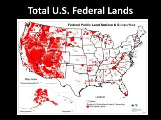
Federal Lands • 31.1% of the surface area – 703 million acres – of the United States • Lands or interest in lands owned by the federal government • Administered by a variety of agencies • Land completely owned (fee title) by the United States • a. Public domain lands • never left federal ownership • acquired in exchange for public domain lands or for the timber on public domain lands • Acquired lands – purchased, condemned, donated, or exchanged • Land to which the federal government does not fully own – e.g. easements, lease
Not classed as Federal Land • Lands on the Outer Continental Shelf - lands lying between the seaward extent of the States' jurisdiction and the seaward extent of Federal jurisdiction • 3-9 nautical miles from shore (depending on the state) and extends 200 nautical miles outward, or farther if the continental shelf extends beyond 200 nautical miles
Not classed as Federal Land • Indian Reservations and lands owned by the United States “in trust” for recognized American Indian tribes • Indian Land Tenure Foundation • Indian Trust Settlement • BIA Office of Trust Services
Federal Lands • Since the objective of federal domestic policy was to privatize the nation's land surface why does the federal government still possess title to approximately one third of it? • Remember • In the eighteenth & nineteenth centuries • individuals migrated into a largely uninhabited • continental interior in response to federal policy • aimed at creating and promoting private • landownership
Rural Uses National Park System National Forests National Grasslands Wilderness Areas National Wildlife Refuges Dams and Reservoirs Army Corps of Engineers Bureau of Reclamation Urban Uses Federal Courthouses (General Services Administration) Customs & Immigration Posts Post Offices Flood Control Structures The Minneapolis Federal Reserve Building VA Hospitals EPA laboratories Fort Snelling National Cemetery Bureau of Mines property Federal Buildings in Minnesota (GSA) Major Uses of Federal Land
Federal Lands • Majority in the West • Federal government once owned as much as 80% of the surface area but disposed of 1.4 billion acres to individuals, corporations and states • Four agencies manage 96% of the federal land • USDA Forest Service (1905) • Bureau of Land Management (1946) • Fish and Wildlife Service (1940) • National Park Service (1916) • Each of these possesses its own mission and responsibilities for managing the lands • Most have acquired title to land throughout its existence
The Department of the Interior manages 445 million surface acres (including 56 million acres of lands held in trust for American Indians) • Much of this lands are located in separate management units • 379 national parks • 74 national monuments • 521 wildlife refuges • 742 dams • Includes 57,000 buildings • The Bureau of Land Management • 264 million acres of land ca. 12% total surface area - 40% of all federal lands • primarily located in the 11 western states and Alaska • Successor to the General Land Office – the federal real estate agency 1812-1946
Bureau of Ocean Energy Management, Regulation and Enforcement (Dept of the Interior) • 560 million acres of subsurface mineral resources throughout the country • 3 billion acres of Outer Continental Shelf lands containing natural gas, oil, and other mineral resources • 42 million acres of the OCS under lease supply approximately 27% of the natural gas and approximately 20% of the oil produced in the United States • Obama to Open Offshore Areas to Oil Drilling for First Time (New York Times March 31, 2010) • Collects and disburses revenues from such leases and onshore mineral leases on Federal and Indian lands
Federal Lands • Administered by a variety of agencies • Administered for a variety of purposes • Acquired by the federal government at different times and in different ways
Military Bases Base Realignment and Base Closure Commission
1796-1934 Privatizing land the principal objective • 1796-1812 Early attempts to privatize land under Congressional supervision • 1812-1946 Privatizing land - the federal real estate agency the General Land Office • 1812-1862 Land as a source of revenue • 1862-1935 Land as a subsidy for settlement - homestead, railways, etc • 1872 Yellowstone National Park established • 1891 President authorized to reserve forest land in federal ownership – not then conveyed to states, corporations, or individuals • 1906 President authorized to protect antiquities on federal land
1796-1934 Privatizing land the principal objective • 1911 Weeks Act allowing the USDA to acquire privately owned cutover forestland for watershed purposes • 1924 Clarke-McNary Act allowing the USDA to acquire cutover forestland for forestry demonstration purposes • 1934 The Taylor Grazing Act ending privatization in general • 1946 The Bureau of Land Management established as successor to the General Land Office • to manage lands owned by the federal government and not reserved • 261 million acres of land, primarily in the 12 Western States and Alaska
Major Legislation • 1872 Yellowstone National Park (16 USC 21 et seq) • 1891 Forest Reserve Act • 1906 Antiquities Act (16 USC 431 et seq) • 1911 Weeks Act (16 USC 552) • 1916 National Park Service Organic Act (16 USC 1) • 1924 Clarke-McNary Act (June 7, 1924, ch. 348, 43 Stat. 653) • 1934 Taylor Grazing Act (16 USC 315) • 1960 Multiple-Use Sustained-Yield Act of 1960 (16 USC 528) • 1964 Wilderness Act (16 USC 1131 et seq) • 1976 Federal Land Policy and Management Act (16 USC 1701 et seq)
Question of Jurisdiction • Nowhere comprehensively compiled • Article 1 Section 8 (Jurisdictional clause) • The Congress shall have Power to exercise exclusive Legislation in all Cases • whatsoever, over such District (not exceeding ten Miles square) as may, by • Cession of particular States, and the Acceptance of Congress, become the Seat • of the Government of the United States, and to exercise like Authority over all • Places purchased by the Consent of the Legislature of the State in which the • Same shall be, for the Erection of Forts, Magazines, Arsenals, dock-Yards, and • other needful Buildings
Minnesota Statutes 1.042 (Laws 1943 c 343) • Subdivision 1. The consent of the State of Minnesota is given in accordance with the Constitution of the United States, Article I, Section 8, Clause 17, to the acquisition by the United States in any manner of any land or right or interest in land in this state required for sites for customs houses, courthouses, hospitals, sanitariums, post offices, prisons, reformatories, jails, forestry depots, supply houses, or offices, aviation fields or stations, radio stations, military or naval camps, bases, stations, arsenals, depots, terminals, cantonments, storage places, target ranges, or any other military or naval purpose of the United States • Subd. 3. Conditions and reservations. The right of the state to cause its civil and criminal process to be executed in any ceded land or place is reserved to the state. The state also reserves the right to impose the following taxes ....
Piecemeal acquisition of the lands, piecemeal acquisition of jurisdiction • Voyageurs National Park • Federal Legislation (Pub. L. 91–661, Jan. 8, 1971, 84 Stat. 1970; 16 USC 160 et seq) • Minnesota Statutes 84B.061 (Laws 1995 c.124) • Minnesota Statutes 1.045 (Laws 1995 c.124)
Voyageurs National Park • Contains 218,054 acres - 134,265 acres of land and 83,789 acres of water • Authorized on January 8, 1971 (16 USC 160 et seq) • The Secretary of the Interior is authorized to establish the Voyageurs National Park in the State of Minnesota, by publication of notice to that effect in the Federal Register at such time as the Secretary deems sufficient interests in lands or waters have been acquired for administration …. • Formally established on April 8 1975 (40 FR 15921) • National Park Service Site • Voyageurs National Park Association • Snowmobile Restrictions in Voyageurs NP • Minnesota Statutes 2005 • The Political Geography of National Parks (Pacific History Review 2004)
Federal lands comprise two groups • Lands the federal government has always owned – lands that were never sold or granted to individuals, corporations, or states • never offered under the federal land statutes • never acquired by individuals, corporations, or states – considered "worthless" • B. Lands that the federal government reacquired after having conveyed them to individuals, corporations, or states • acquired voluntarily – by purchases, exchanges, donations • acquired involuntarily – by condemnation, confiscation, bankruptcy proceedings
National Forest System • National Forests legislation 16 USC Chapter 2 • Superior National Forest • Boundary Waters Canoe Wilderness Area • Isaac Walton League • Chippewa National Forest • Roadless Areas • New rule opens up forests • Off-highway regulations • Forest Industry Court Cases • National Grasslands • National Trails
National Park Service • Manages a national park system comprising • 379 separate units that cover over 80 million acres • 2 million acres of which are privately owned • approximately 16,000 permanent structures and • 8,000 miles of roads • 161,498 urban acres and 72,380,105 rural acres • National Park legislation 16 USC 1 et seq • NPS regulations. 36 CFR 1-199 • Court case Edmonds Institute, et al v. Babbit • Listing of Acreage by Unit • Park Histories
Chronology of the National Parks Lee, Ronald (1972) Family Tree of the National Park System
National Park Service in Minnesota • 16 US Code National Parks, Military Parks, Monuments and Seashores • Voyageurs National Park • Wild and Scenic Rivers Legislation • St. Croix National Scenic Riverway • Lower St. Croix • Mississippi National River & Recreation Area • Pipestone NM • Grand Portage NM • North Country National Scenic Trail
St Croix Wild & Scenic River • Upper St Croix authorized in Wild & Scenic Rivers Act of 1968 (16 USC 1271 et seq) • The Lower St. Croix River added in 1972 • National Park Service Site • Time and the River: A History of the St. Croix (Karamansky, 2002)
Upper St. Croix • The segment between the dam near Taylors Falls, Minnesota, and the dam near Gordon, Wisconsin, and its tributary, the Namekagon, from Lake Namekagon downstream to its confluence with the Saint Croix • To be administered by the Secretary of the Interior • “No funds … may be expended to acquire or develop lands in that portion of the Saint Croix River between the dam near Taylors Falls, Minnesota, and the upstream end of Big Island in Wisconsin, until sixty days after the date on which the Secretary has transmitted to the President of the Senate and Speaker of the House of Representatives a proposed cooperative agreement between the Northern States Power Company and the United States”
NSP Agreement • “the company agrees to convey to the United States, without charge, appropriate interests in certain of its lands between the dam near Taylors Falls, Minnesota, and the upstream end of Big Island in Wisconsin, including the company’s right, title, and interest to approximately one hundred acres per mile” • the company retains the lands and interests in the lands between said points adjacent to the river in a manner which shall complement and not be inconsistent with the purposes for which the lands and interests in land donated by the company are administered under this chapter
Lower Saint Croix, Minnesota and Wisconsin • The segment between the dam near Taylors Falls and its confluence with the Mississippi River • The upper twenty-seven miles of this river segment shall be administered by the Secretary of the Interior • The lower twenty-five miles shall be designated by the Secretary upon his approval of an application for such designation made by the Governors of the State of Minnesota and Wisconsin • The Wild & Scenic Lower St. Croix River (Minnesota)
Stillwater Bridge • Minnesota Department of Transportation • Sierra Club sues to block new Stillwater bridge (Minnesota Public Radio, 2007) • Sierra Club protests St. Croix River bridge (Star Tribune, 2009) • Judge blocks 'massive' bridge over St. Croix Star (Tribune March 11, 2010) • It’s time to build St. Croix bridge (Star Tribune April 7, 2011)
Mississippi National River & Recreation Area • Established in 1988 (16 USC 460zz et seq) • Boundaries enclose about 54,000 acres and 72 miles of river • Either side of the Mississippi - from Dayton and Ramsey to Hastings • Only 35 acres are owned by the federal government • Contain the only gorge and waterfall on the main course of 2,350 miles of river • A New Mississippi National River and Recreation Area (Minnesota House Research)