Download
1 / 18
180 likes | 249 Views
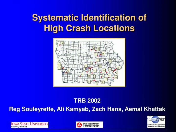
Systematic Identification of High Crash Locations. TRB 2002 Reg Souleyrette, Ali Kamyab, Zach Hans, Aemal Khattak. HES Hazard Elimination Safety Program. Rate rank. Top 200. Engineering study (top dozen or so). Overall rank. Frequency rate. $loss rank. 1999. 1998. 1997. 1996.

E N D
Systematic Identification of High Crash Locations TRB 2002 Reg Souleyrette, Ali Kamyab, Zach Hans, Aemal Khattak
HES Hazard Elimination Safety Program Rate rank Top 200 Engineering study (top dozen or so) Overall rank Frequency rate $loss rank 1999 1998 1997 1996 Problems … no consideration of type, under using data we have
1999 1998 1997 1996 Opportunity …
Methodology • Identify Problem Types • Collect/develop Databases (e.g., curves) • Rank Locations • Share Results with Field Personnel* • Validation • Education • Adjustment • Use for low-cost mitigation • Follow up studies of causal factors/design implications, better ranking “… low cost opportunities can be better identified by familiarity with a site than by automated network screening.” Hauer, 2002
Safety impact of… Elderly drivers Horizontal curve characteristics (e.g., degree, radius) Speed limits of 50 mph or more on expressways Traffic volume and traffic mixture Speed limit Shoulder surface (e.g. paved, unpaved) Number of access points per mile Pavement markings Signalized turning bays Crossing the centerline/head-on Turn lanes in creating traffic turbulence and weaving High crash locations… During Wet weather conditions For Run-off-the-road crashes For Fixed-object crashes At Urban 4-lane undivided roadways At Signalized intersections At Stop-signed intersections Rural expressway intersections Choose those where Promising treatments are possible Safety community perceives a problem Potential Study Topics
Study Topics • Head-on • Horizontal • Curves • Urban, Four-lane • Undivided Corridors • Four-lane, Rural • Expressway Intersections • Fixed • Objects
High Crash Curve Methodology Define Curves (bearing/manual) [DGPS CL] [GIMS Cartography] [Aerial Photos] Identify GIS segments proximate to “curve” crashes [ALAS] Join Crashes/ Curves A Field Personnel Change Design Derive Curve Radius and Length E Implement Mitigation Rank Locations (Freq, Sev, Rate) Significance Test/Causal Factors
Curves: Data Integration DGPS Driven Centerline “On Curve” Crashes Aerial Photography Cartography
Curves: Developing the Database Horizontal Curves 1. Manual Definition 2. Change in bearing between road segments
Derived from new horizontal curves GIS Curves: Calculating Curve Parameters
High Crash Curves: Validation Present Lists and Maps to Field Engineers Sometimes Educate • Misconceptions • Omissions Sometimes Adjust • Curve definition • Human error
High Crash Curves: Results • Statewide average = 1.4/mvm, f=1.9, $55K • Top 30 average = 11.5/mvm, f=9.5, $490K • Worst = 27.4/mvm, f=14, $960K • 5% of crashes occur at top 30 locations (1% of curves) • 11% of fatalities occur at top 30 locations • Curve length and degree of curvature are significant causal variables.
BEFORE AFTER High Crash Curves: Mitigation
Fixed-Objects Struck:Important Factors • Interstate: terrain, pavement type, barriers • US Hwy: barriers and surface width • Other Primary: terrain, pavement • Farm: shoulder & pavement type • Local: terrain, pavement, #lanes, speed limit … and, as expected, functional class matters
Fixed-Object Struck: Potential Problem Locations US Highways, No Median Barrier, Narrower Surface Widths
Closure • Curve database developed • Systematic Approach that recognizes: • Problem type • Mitigation potential • Public/professional perception/input • Treat locations that never would have made it to the SICL
Thank you • Sponsor: Iowa Highway Research Board • Report: www.ctre.iastate.edu • Email: reg@iastate.edu • 515-294-5453