Download
1 / 5
50 likes | 172 Views
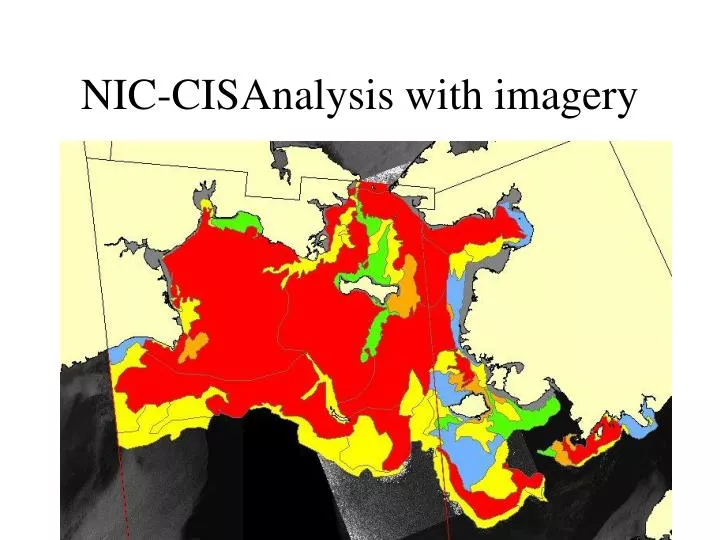
NIC-CISAnalysis with imagery. NIC Analysis Bering Str. Discussion. Case Study 2 Synchronous Analysis of Bering Strait East Imagery April 1 2009 AARI and NIC,CIS Both NIC AARI use using Arcmap, CIS Arcinfo—incompatible, therefore worked with NIC

E N D
Discussion • Case Study 2 • Synchronous Analysis of Bering Strait East Imagery • April 1 2009 • AARI and NIC,CIS • Both NIC AARI use using Arcmap, CIS Arcinfo—incompatible, therefore worked with NIC • Goal image analysis of Bering strait by two separate experts. Resulting products will be scrutinized for similarities. • Missing in this case study was direction what scale should we be analyzing: i.e. how detailed, what is the time limit. • This is important to ensure parody in the exercise. We also had difficulties in establishing common projections: stereographic, NIC WGS84, problems with uncommon central meridian. So we ended up using the US data. • AARI • Loads imagery for May 06 • Dmsp-ols-.55 km res/RSAT-100m res. For May 5 & 6th • Would reuse yesterdays fast ice if available. • Starts with open water/edge and switches between various sensors to complete exterior edge. • -then heads to fast ice..uses OLS and prefers NOAA and MODIS as opposed to SAR for fast ice. • -when fast ice completed then moves to concentration of interior ice polygons. • There is an optimal zoom level to work at. • Know you client. • Vladimir does all his lines and then his eggs. • NIC/CIS • NIC commences with fast ice, the edges, and then polygon tagging. • CIS would roll over fast ice from yesterday. Reanalyze fast ice and make changes as required. • CIS analyst, depending on number of frames to analyze will work in subsections. If small scale. CIS adds eggs incrementally, while NIC add all eggs at end of line definition. • Eg. If there were 3 rsat frames may do one frame in its entirety before moving to next. • Both can work either way….generally speaking we all go from most easily identifiable ice feature to more difficult