Download
1 / 19
190 likes | 276 Views
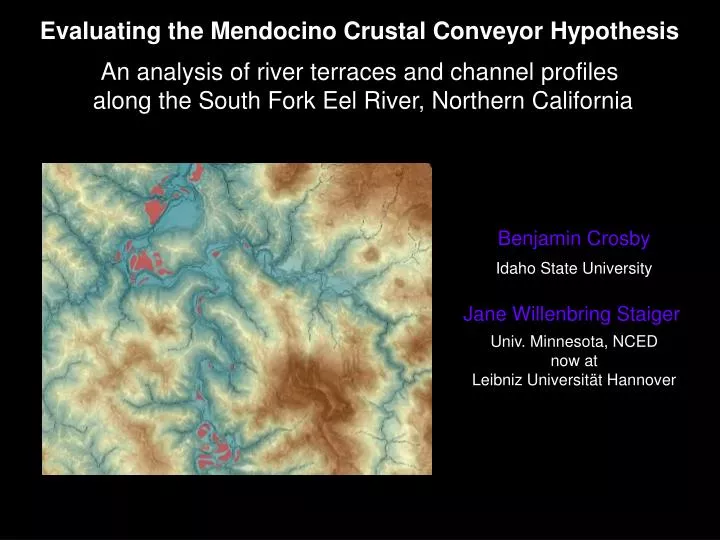
Evaluating the Mendocino Crustal Conveyor Hypothesis An analysis of river terraces and channel profiles along the South Fork Eel River, Northern California. Benjamin Crosby Idaho State University Jane Willenbring Staiger Univ. Minnesota, NCED now at Leibniz Universität Hannover.

E N D
Evaluating the Mendocino Crustal Conveyor Hypothesis An analysis of river terraces and channel profiles along the South Fork Eel River, Northern California Benjamin Crosby Idaho State University Jane Willenbring Staiger Univ. Minnesota, NCED now at Leibniz Universität Hannover
Field Location and Tectonic Setting South Fork of The Eel River
N S • The Mendocino Crustal Conveyor • Crustal thickening at North End due to influx of upwelling material cooling against crust. • Slab window exposes crust to asthenospheric upwelling. • Everything migrates northward (Furlong and Schwartz, 2004)
Crustal Thickening Mantle Flow & Buoyancy (Furlong et al., 2003)
Expectation: Double-humped wave of rock uplift in wake of migrating Mendocino Triple Junction South Fork of The Eel River (Lock et al., 2006)
Confluence with Mainstem Eel River Hypothesis Modern channel profiles and strath terraces from the Eel River reflect the northward propagating wave of thermal uplift USGS 10 meter DEM
Terrace Mapping Procedure • Identify “flat” areas adjacent to the channel. • Create polygon shapefile of flat areas. • Identify average elevation of each terrace • Find the distance upstream of each polygon. • Create terrace profiles
Terrace Location Map n = 264 (Note rotation from north axis) Outlet to Mainstem Eel. N 20 kilometers
Channel Profile From Junction with Mainstem Eel River To headwaters of the South Fork of the Eel River -using 10m USGS DEM-
Channel Profile From Junction with Mainstem Eel River To headwaters of the South Fork of the Eel River -using 10m USGS DEM-
Channel Profile From Junction with Mainstem Eel River To headwaters of the South Fork of the Eel River -using 10m USGS DEM-
Channel Profile From Junction with Mainstem Eel River To headwaters of the South Fork of the Eel River -using 10m USGS DEM-
Channel Profile From Junction with Mainstem Eel River To headwaters of the South Fork of the Eel River -using 10m USGS DEM-
1900 Channel steepness Index 40
Channel steepness 40 1900
Detrital Cosmogenic Erosion Rates -modern samples collected from the mainstem -Erosion rates increase systematically downstream (0.1-0.5 mm/yr) -Progressive dilution of low rate samples from headwaters? -Spatial gradient in uplift rate or transient response? N 20 kilometers
Conclusions • Division of basin into relict and adjusting regions • Amount of incision decreases to the North • Northward propagating welt of uplift produces both a downstream propagating knickpoint that is followed by an upstream propagating one • Erosion rates derived from mainstem detrital cosmogenic sampling suggest increasing erosion rates downstream. The systematic increase could be due to the mixing of two distinct populations or a systematic change in erosion rate downstream. Tributary analysis pending! • Tributary knickpoints, coincident with the height of mainstem terraces, provide the greatest measure of basin response to a rolling wave of uplift
eros mm/y uncert. sample name UTM E UTM N 0.22 0.02 ANG05SFE11 444750 4398400 0.17 0.02 ANG05SFE12 445912 4400636 0.34 0.03 ANG07SFE06 432395 4423851 0.29 0.02 ANG07SFE07 437381 4414092 0.32 0.02 ANG07SFE09 441830 4408428 0.41 0.03 ANG07SFE10 432664 4430280 0.49 0.05 ANG07SFE11 430997 4443875 0.48 0.03 ANG07SFE12 425220 4457103 0.52 0.04 ANG07SFE13 421188 4467460 New data