Download
1 / 32
320 likes | 446 Views
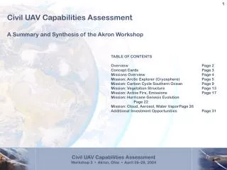
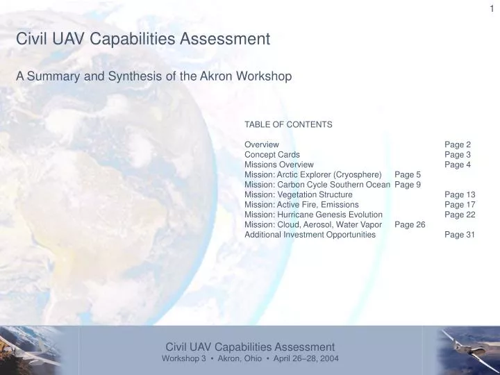
Civil UAV Capabilities Assessment A Summary and Synthesis of the Akron Workshop . TABLE OF CONTENTS Overview Page 2 Concept Cards Page 3 Missions Overview Page 4 Mission: Arctic Explorer (Cryosphere) Page 5 Mission: Carbon Cycle Southern Ocean Page 9

E N D
Civil UAV Capabilities Assessment A Summary and Synthesis of the Akron Workshop TABLE OF CONTENTS Overview Page 2 Concept Cards Page 3 Missions Overview Page 4 Mission: Arctic Explorer (Cryosphere) Page 5 Mission: Carbon Cycle Southern Ocean Page 9 Mission: Vegetation Structure Page 13 Mission: Active Fire, Emissions Page 17 Mission: Hurricane Genesis Evolution Page 22 Mission: Cloud, Aerosol, Water Vapor Page 26 Additional Investment Opportunities Page 31
Overview The purpose of this workshop was to identify capabilities needed in future civil UAV’s to enable informed funding decisions on key technologies. This is focused to reveal science sensor technology gap data in more details than just miniaturization and will provide information for a section in our assessment document. We also need to determine power and propulsion technology shortfall data. Our task is to develop a Civil UAV Capability Assessment for a 2015 Time Frame. We are intending to serve the Sub-Orbital Science Program (Yuhas), the Vehicle Systems Program (Camacho) and to complement the DOD roadmap. We will consider Homeland Security, Commercial, Land Management, and Earth Sciences in our assessment. Our objectives are to document future missions of civil UAVs based on user defined needs, the technologies necessary to support those missions; to discuss SOA of those technologies, identifying those in progress, those planned, and those for which no current plans exist. We also intend to provide the foundations for development of a comprehensive civil UAV roadmap. This document is a summary of the group’s work.
Concept Cards During the introductory presentations on Wednesday, April 27th, participants were introduced to the current state of UAV capabilities, platforms and roadmaps. These concept cards were captured during those presentations.
Missions: Overview Context After completing the workshop in Boulder the following 6 missions from the Sub-Orbital Science Missions of the Future Workshop were defined as suitable to be used as example of mission types. Arctic Explorer (Cryosphere) Carbon Cycle Southern Ocean Vegetation Structure, Composition, and Canopy Chemistry Active Fire, Emissions, and Plume Assessment Hurricane Genesis Evolution and Landfall Cloud, Aerosol, Water Vapor, and Total Water Measurements These missions were used in this workshop to stimulate the first set of conversations to assess the capabilities and technology gaps for both instrumentation/sensors as well as power and propulsion.
Mission: Arctic Explorer (Cryosphere) Brief Description:This mission supports measurements of the dynamics of the breakup of polar glacier and polar ice sheets. The measurements enable direct observation of the evolution in time of ice and land topography, iceberg volume, glacier profiles, and glacier channel profiles and provide data for validating simulations of these dynamics and their interaction with the ocean environment. Sensor Package The breakout group working on this mission identified the following sensors required to complete this mission: Active Microwave Passive STAR (and salinity) V/IR Imager / Spectrometer Magnetometer Topo Lidar (downsized) Stereo Imager (miniaturized) High Resolution Nav. This suite of sensors solve a number of other science challenges, not just the cryosphere. We can look at volcanoes, solid earth and geology, etc. Most of these sensors are pretty well-developed. The passive STAR is the least developed - this is the biggest technology gap. All of the others need to be repackaged and miniaturized. For the spectrometer this could actually allow improved performance.
Mission: Arctic Explorer (Cryosphere) Sensors/Instrumentation To do high-sensitivity measurements, we need a platform that can go very low and slow, while maintaining a constant land speed - this is critical for these kinds of remote sensing instruments. This gives us a much better signal-to-noise ratio. We would love to get a ground speed of 5 knots, but this would require some serious headwinds. Operationally, cloud cover will be an issue for some of our objectives. We want to record data on board, and we will need on/off commands for some data sites. We do not see any issues for logistics and deployment. This is pretty standard operationally. The total payload will probably be just under 200kg. It seems like a good Predator package, but it should all be measured under 12,000 feet. We need to pay attention to any extra power that might be required to heat these instruments in extremely cold conditions.
Mission: Arctic Explorer (Cryosphere) Power & Propulsion On the Antarctic mission, we questioned when we would be taking this data, such as in winter when you're fighting a lot of winds. We considered using a dirigible, but we weren't sure if that would fit the requirements. We were a little worried if it is really cold, there is a lot of distortion, we have problems with the turbine. If you're using light fuel, it's probably not a problem. The antarctic is colder than the arctic. We saw minus 74 C. This impacts the type of fuel you use. They used JP5 for that. We're at JP8 now. We need to do a little more work on this.
Mission: Arctic Explorer (Cryosphere) Technology Development Opportunities
Mission: Carbon Cycle Southern Ocean Brief Description:The primary goal of this mission would be a definitive measure of net annual CO2 uptake from the atmosphere by the Southern Ocean, including its inter-annual variability, and relation to other known quantities. The mission would also add greatly to knowledge of vertical mixing in the atmosphere over the Southern Ocean. The results would serve as inputs to, or constraints on, models of the carbon cycle, improving understanding of many aspects. Sensor Package The breakout group working on this mission identified the following sensors (or capabilities) required to complete this mission: ICO2 H2O Radiometer Ocean color imager Raman for CO2 Lidar (scatterometer optic/RF) Turbulence probe Surface temperature FTIR Deployable buoy Boundary layer L-band radiometer (1.4ghz) In the near-term, we captured what is possible in FY06. We used the instruments recommended in a recent paper, and we added 2-channel GPS to measure surface roughness. We did not include See-and-Avoid. We have assumed that will always been an operator in the loop ミthis does not have full autonomy.
Mission: Carbon Cycle Southern Ocean Sensors/Instrumentation Developing the lightweight antennae will be one of our biggest challenges. We can increase our autonomy and our data capacity. Our total mass is less than 200 pounds and just over 1000 watts. This depends on a 3000 mile range. The speed is negotiable.Our CO2 measurements will require even more resolution than a 10-pound LIDAR can provide. We also need really good measurements of water vapor. You run the risk of a false signature. We also need to talk to the wind LIDAR. Once we get to 2010, we can develop a much better solution. We could develop a CO2 LIDAR. We could add a three-channel LIDAR to measure the winds. We will add a hyperspectral camera. Infrared (for looking at the sea surface) will be a challenge because of the cooling issues. An FTIR has the same cooling issues. It will take until 2010 to develop and image analysis algorithm. Buoys: TBD
Mission: Carbon Cycle Southern Ocean Power & Propulsion We believe that the current UAV can handle the mission. Payload mass is shown there at 66 lbs. This is low weight. So these are mild and unless there is some flight concern about turbulence, what we have now would work fine. Between the small and medium platforms you have a good jump in power. There may be some modification to a small UAV and have what you need. One thing is that in your power requirements, you need to specify if the requirements are simply for payload or does it include the communications package?
Mission: Carbon Cycle Southern Ocean Technology Development Opportunities
Missions: Vegetation Structure, Composition, and Canopy Chemistry Brief Description:This suborbital mission would help scientists improve the characterization of terrestrial biomass, leaf level chemistry and canopy water content. The science data will provide 3-dimensional vegetation structure and information on composition and chemistry. In addition, the observations will elucidate functional groups and physiological impacts on the carbon cycle. Sensor Package The breakout group working on this mission identified the following sensors (or capabilities) required to complete this mission: Radar (P, L, X band - polarimatric Hyperspectral Lidar On-board recorder For this particular application, we do not think that there is any UAV-specific advantage. These missions are short-duration, there are no opportunistic measurement requirements (vegetation tends to change quite slowly), and alternative approaches exist. There are a lot of technologies used for other applications, however, that could be used for our purposes.
Missions: Vegetation Structure, Composition, and Canopy Chemistry Sensors/Instrumentation We want to use radar, hyperspectral radar, LIDAR, and an on-board recorder. Some of these technologies need to be adapted to the UAV platform, but this is not a major hurdle. There are some key components that will be required for the antennae, telescope, and focal point array. There are some general technology challenges for the UAV. It requires autonomous operations because it uses different platforms. It requires a steerable antenna. We need to be able to correct the flight path in-flight. We need high-power modules. A 12 hour mission could generate up to 7 terabytes of data, given the instruments onboard. There are no real-time requirements for this data, so we do not need instantaneous access to it. We need to find the most cost-effective means of transmitting and storing the data. We need to coordinate the flight path, but we do not need to coordinate the flight paths of multiple aircraft in formation. One UAV will have X-band and L-band, and a second UAV will carry LIDAR and hyperspectral. They do not need to fly at the same time.
Missions: Vegetation Structure, Composition, and Canopy Chemistry Power & Propulsion The way we figure the power and mass for the state of the art UAV situation, we need to reduce the power by half and the weight by a quarter. The weight of the antennae system is in pretty good shape. The key thing is to modularize these components. Reducing the weight of the battery and the sensor system. It will require interferometric measurements and differential GPS. You will need a flight controller as a critical aspect. We will have a data rate transfer of 1mb/sec. Having optical communication is a good approach. There should be a lot of trades in here. We think this mission is doable with current technology. The current assets will work, We didn't see a real challenge here at all.
Missions: Vegetation Structure, Composition, and Canopy Chemistry Technology Development Opportunities
Mission: Active Fire, Emissions, and Plume Assessment Brief Description:This suborbital mission would help Earth Science scientists further understand the influence of disturbance on carbon cycle dynamics by observing and measuring: the atmospheric chemistry; the thermal intensity time-series; the plume composition, including the volume, albedo, particle size distribution; and, the fuel type and quality. The measurements would also provide the atmospheric composition focus area a better understanding of fire plume chemical constituents resulting from different fuels under different intensities of fire. Instruments Remote Imaging Hyperspectral Lidar Gas Filter Correlation Radiometer In-Situ Mass Spec CI Gas Chromatograph NDIR Spectral Radiometer Chemical Microsensors Particulate Sensors Tunable Diode Laser Gas Bottles UV Absorption 03 Sensor Aerosol Spectrometer Condensation Neurli Counter Metrology System Flame Ionization We have a long list of things we want to measure. We did not have any fire specialists on our team, but we think we did a good job. We need a long list of equipment as well.
Mission: Active Fire, Emissions, and Plume Assessment Sensors/Instrumentation This mission is perfect for UAVs. One UAV would be high up making measurements of aerosols and humidity radiation and one UAV low enough to capture measurements where you don't want a manned craft. The long endurance for the upper one is also a challenge we have. From this list of instruments (and what they could measure), we tried to assemble a package of instruments that would measure the most important items, including CO and CO2. With this list, we can now talk about miniaturization to see if such an effort makes any sense. Many of the instruments are so tiny that they are essentially free for the mission in terms of size, weight and space. We developed weight and power numbers for each item, but we have not yet summed them up. We want to use LICOR to measure CO2. We want to use a HSRL LIDAR ミ a very powerful instrument for this mission. Another requirement for these instruments is onboard calibration gasses. Finally, we wanted to talk about technology gaps. We feel that the multi-spectral is pretty good for use today (not a hyper-spectral). Many of these instruments are in pretty good shape. Some instruments need some help to run more autonomously. There are some physical limits to how far we can miniaturize the LIDAR. We will need to package our instruments differently when we start packing them into the tight spaces of UAVユs. This is in conflict with another teamユs report which encourages plug-and-play. There will be data management problems onboard the UAV.
Mission: Active Fire, Emissions, and Plume Assessment Sensors/Instrumentation
Mission: Active Fire, Emissions, and Plume Assessment Power & Propulsion The remote UAV can handle this. It depends on how many of these you want. Can you stage them by regions? Then we could send one out as one wears down. The plume UAV is also possible. This speaks to the dirty and dangerous and is probably not dull. This may need a bit of work because of the temperature and amount of soot. There is a story in which soot was going into the engines and they would just shut down. This could be a challenging environment to work in. We need to find out more information about the conditions. If you have to keep temperatures constant for the instruments, then you need a heating cooling system either by payload bay or instrument by instrument. The current technology of UAVs is complete right now for this mission than any of the others. You're closer to a total application. We haven't talked about airspace yet. We have to partner with the forest service on this. But from an operational standpoint, we're ready to do this. Control burns are the place to do the science. The authorization to have airspace for a control burn is from the Forest Service. There are some places that you can go to your restricted areas with UAVs right now.
Mission: Active Fire, Emissions, and Plume Assessment Technology Development Opportunities
Mission: Hurricane Genesis Evolution, and Landfall Brief Description:The purpose of this mission would be to accomplish observations of hurricanes to improve predictions of hurricane paths and landfall. This approach would use high altitude remote sensing to gather data on precipitation, clouds, electrical phenomenon, microphysics, and dust. Daughter ships or drop-sondes would gather data (four-dimensional cubes of thermodynamic variables and winds) at lower altitudes. Additional data would be gathered in the boundary layer (sea surface temperature and surface winds, surface imaging, turbulent fluxes, water surface state). Measurements of this type would improve hurricane modeling capability to increase human safety. Sensor Package The breakout group identified the following sensors (or capabilities) required to complete this mission: Optical imager Sondes uWave sounder Radar GPS Reflectance Lidar Infra-red pyrometer Near surface sea temperature IR Sounder Our recommended solution is to deploy multiple high-altitude platforms. We would instrument one UAV with microwave and a few other sensors. We would take the adaptive high altitude platform to the outer storm or the near-storm environment - weユll put our LIDARs on that vehicle. We will put our drop-sondes on another UAV to validate our remote sensing instruments, but we do not want to use them routinely because of the weight that they add to the mission. This replaces high, middle, and low-altitude platforms.
Mission: Hurricane Genesis Evolution, and Landfall Sensors/Instrumentation Our goal is to get data that we cannot get from a satellite or manned mission. We want a balanced, 4D ‘grid’ of sounding points. We need a new technique for measuring surface temperature (about 1m below the surface) - we donユt know how to do that from a UAV.
Mission: Hurricane Genesis Evolution, and Landfall Power & Propulsion This is a challenge from multiple directions from both an airframe and power and propulsion standpoint. We need to get there quick as well as stay there for a long time as well as get to various points through the storm. We need both convective levels to get data for both hurricane and cloud. We might be able to come up with something cheap and expendable. All of these are challenging for us. Particularly the high and long endurance one. We had quite a bit of discussion. We wondered if we could get it out there another way. We keep coming up with the dirigible idea. Can you fly something out there that can keep it out there for awhile? There are multiple ways of handling it.
Mission: Hurricane Genesis Evolution, and Landfall Technology Development Opportunities
Mission: Cloud, Aerosol, Water Vapor, & Total Water Brief Description:This suborbital mission would study transformations of aerosols and gases in cloud systems. Convective systems, Sea breeze cloud formation, Marine stratiform, Contrails in the Central U.S. in air traffic regions and ship tracks in oceans, Synoptic scale systems & Fronts, and Cirrus outflow. • Sensor Package • The breakout group identified the following sensors (or capabilities) required to complete this mission: • Instrument/Measurement • Cloud and aerosol lidar • Doppler radar • Optical imager • 95 GHz radar • Nav data (from the aircraft) • Temperature profiler • Water vapor lidar • Broadband UV-IR radiometer • FTIR radiometer • Microwave radiometer • Lightning detection • Temperature profiler On our board, we indicated the priority for each of these instruments. H means high, M is medium, and L is low. For the three lower-flying platforms, we have extra space but we are a little bit overweight (about 10-15%). Many of these sensors will be smaller in five years. The real problem we have is power, and there’s not much we can do about it in the instruments. Many of the probes hang outside the UAV, they need to be de-iced, and that required power. The aircraft guys have to give us more power – up to 5.7 KW.
Mission: Cloud, Aerosol, Water Vapor, & Total Water Sensors/Instrumentation In the remote UAV, the numbers are huge. We need 16 cubic feet, 755 pounds, and 4.35KW. We hope that the next generation of instruments will combine the functions of multiple instruments of today - this would save us on weight and power demands. Let’s combine the LIDARs and the RADARs as much as possible. If we can do this, we get much closer on all of the parameters for today’s high flyer. There are some integration issues that we need to consider. Some instruments need to be easily accessed after a flight. Some detectors need to be cooled with liquid nitrogen. Many instruments have external parts (probes, optical windows, etc.), and these parts need to be accommodated by the platform. The water vapor detection inside the convective system might be problematic.
Mission: Cloud, Aerosol, Water Vapor, & Total Water Sensors/Instrumentation
Mission: Cloud, Aerosol, Water Vapor, & Total Water Power & Propulsion This is in a similar class as the mid-air convective. The challenge here is not so much in weight or power, it's more the gradient updrafts and keeping the thing in control. It might be similar to the hurricane mid-altitude concerns too. We have to make sure we don't get something that sucks and wipes out the entire engine. How much control authority are we going to have in the engine face? Can we give you enough power? We need to know more about the power needs. It's tough to say how much of a challenge this is.It could be that one of the current UAVs with or without modifications could handle this.
Mission: Cloud, Aerosol, Water Vapor, & Total Water Technology Development Opportunities 1. Lidars (a) Combine water vapor and cloud/aerosol lidar and (b) Add capability to cloud/aerosol lidar: make it a High Spectral Resolution Lidar (HSRL) that measures - extinction at 355 and 532 nm - backscatter at 355, 532, and 1064 nm This enables retrievals of aerosol effective radius, concentration, real and imaginary refractive index, and single scatter albedo. Optical window may be an integration/accommodation issue. Target accommodations for combined instrument: 8 cf, 300 lbs, 1.5 kW 2. Radars: Combine the two radars Target accommodations for combined instrument: 10 cf, 300 lbs, 1.5 kW Windows/radomes may be an integration/accommodation issue. 3) On-board data analysis and interpretation
Additional Investment Possibilities Very little water vapor lidar transmitter development ongoing at this time. Funding needed in this area. Inteferometric HSRL receiver technologies are not being developed in the US. Work ongoing in Europe, but insight into progress and problems difficult to obtain.