Download
1 / 41
430 likes | 869 Views
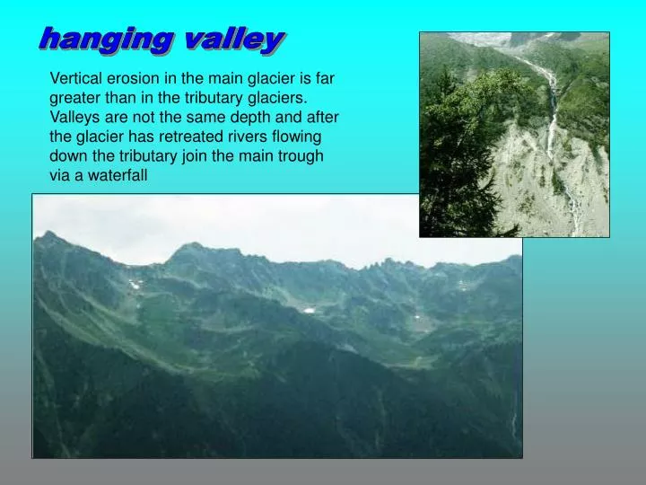
hanging valley. Vertical erosion in the main glacier is far greater than in the tributary glaciers. Valleys are not the same depth and after the glacier has retreated rivers flowing down the tributary join the main trough via a waterfall. Position photograph taken from. hanging valley.

E N D
hanging valley Vertical erosion in the main glacier is far greater than in the tributary glaciers. Valleys are not the same depth and after the glacier has retreated rivers flowing down the tributary join the main trough via a waterfall
Position photograph taken from hanging valley
Lauterbrunnen Switzerland hanging valley At the base of a waterfall alluvial fans are sometimes found as a result of deposition.
alluvial fan alluvium = silt deposited by a river
waterfall V-shaped valley U-shaped valley hanging valley
Ullswater Lake District ribbon lake When a glacier moves along its valley some parts are deepened more than others. When the glacier retreats the deepened sections fill with melt water and become lakes. The English Lake district owes its character to these narrow ribbon lakes along its valley floors.
Haweswater Lake District ribbon lake Ribbon lakes can also be formed when glacial deposits build a natural barrier across a glacial trough
Edinburgh Castle crag and tail These are partly erosional, partly depositional features The rock face facing the ice is steepened by glacial erosion. Material is deposited on the opposite side to form a tail of boulder clay.
Direction of diagram Always align a map and a diagram before identifying features. Ben Nevis
11 landforms of glacial erosion Identify the features marked on the diagram by matching them to the names of features listed below. Arête; Hanging Valley; Corrie (Cirque); 'U' shaped Valley; Alluvial Fan; Pyramidal Peak; Corrie Lochan (Tarn); Misfit Stream; Ribbon Lake; Truncated Spur; Screes.
11 landforms of glacial erosion 1 is a Pyramidal Peak because it has steep, triangular faces divided by sharp ridges or arêtes. 2 is an Arête, because it is a sharp ridge between corries. 3 is a Corrie or cirque, because it is an armchair shaped hollow with steep back and sides. 4 is a Corrie Lochan or Tarn, because water has gathered in the hollow in the floor of the corrie.
11 landforms of glacial erosion 5 is an Alluvial Fan, because it is a fan shaped pile of rock material (alluvium) washed down by the stream. 6 is a Ribbon Lake, because it is a long narrow lake in a part of the valley cut deeper by the glacier. 7 is a Truncated Spur, because the ridge has been cut off sharply by the ice that flowed down the main valley.
11 landforms of glacial erosion 8 is a Misfit Stream, because it is far too small to have cut the valley. 9 is a Hanging Valley, because the valley floor is much higher than the floor of the main valley. 10 is a 'U' Shaped Valley, because it has steep sides and a nearly flat floor. (The other side of the valley is missing in this cut-away diagram). 11 are Screes which are piles of loose rocks and boulders mainly formed by frost shattering.
Landforms of weathering Landforms of glacial erosion Landforms of glacial deposition Landforms of fluvioglacial deposition glacial landforms crag and tail moraine erratic drumlin esker kettle outwash plain corrie tarn arête horn U-shaped valley truncated spur hanging valley fiord ribbon lake scree
lateral and medial moraine ground moraine fluvioglacial deposition glacial deposition snout outwash sand and gravel terminal moraine glacial deposition
glacial deposition Materials carried by the glaciers are deposited in two main ways; Glacial Deposits (unsorted) dumped from the melting ice, such as moraines and till. These are jumbled mixtures of broken rock material of many different sizes. Fluvo-glacial deposits (sorted) washed out of the ice by meltwaters, such as eskers. These are more rounded and have been sorted by the action of the water, the heavier materials being laid down first. boulder clay is a glacial deposit outwash sand and gravel is a fluvioglacial deposit
moraine • Moraine is the waste material worn away and collected by the ice • It is angular in shape • Glacial deposits are poorly sorted, ie all different sizes and rock types are mixed together.
moraine • Lateral moraine is found on the sides of the glacier. Scree, from frost shattering, is an important source. • Medial moraine is found down the middle of the glacial surface and occurs when the inner lateral moraines of two glaciers join. • Ground moraine is found at the base (bottom) of the ice. It is also called till or boulder clay. • Terminal moraine is found in front of the snout of the glacier if it is stationary. It represents the maximum advance of the ice.
boulder clay Boulder clay is glacial moraine consisting of thick clay with angular rocks. The exact composition will depend on the rocks eroded by the glacier. Boulder clay is sometimes called till.
terminal moraine The line where the ice-sheets end is marked by a ridge of thick, unsorted glacial deposits. This is called the terminal moraine ridge. ice outwash snout terminal moraine In front of this ridge, the melt water carries fine sand, silt and clay depositing it further on. This forms an outwash plain.
erratic Erratics are large rocks that are completely different from the type of rocks on which they rest They were carried by the ice-sheet, sometimes for hundreds of kilometres and then deposited.
drumlin Drumlins are smooth, rounded mounds of ground moraine. The steep side faces the ice movement. Drumlins often occur in swarms or groups.
Glacial streams are found under the ice-sheet.They are loaded with debris (sand and gravel) carried by the meltwater.As the ice-sheet retreats, the river deposits its load. esker
glacier river flowing under ice depositing sand and gravel An esker is a steep-sided, long, winding ridge, made up of gravel and sand. esker
sand and gravel boulder clay t e r m I n a l m o r a I n e ICE MELTWATER ESKERS KAMES
kettle depression formed when ice melts depression filled with water to form kettle lake block of ice outwash sand and gravel
sorted sands and gravels spread out to form outwash plain glacier meltwater Infertile outwash often covered by bog or forest outwash plain
Identify the features shown on the diagram by matching the numbers to the names given. Esker; Terminal Moraine; Till (Ground Moraine/Boulder Clay); Outwash Plain; Drumlin; Kettle; Outwash Sands and Gravels.
1 is a Terminal Moraine. A hummocky ridge of unsorted stones, boulders and clays dumped by the glacier at the furthest point it reached 2 is a Drumlin. A long, rounded mound of till, moulded under the flowing ice. Its narrower end points in the direction that the ice was moving. They usually occur in groups (swarms) 3 is a Kettle. A water filled hollow left when a block of ice in the till or outwash melted to leave a hollow 4 is an Esker. A long, winding ridge of sands and gravels left by a stream which ran in an ice tunnel under the melting glacier
5 is Till (Ground Moraine or Boulder Clay). A mixture of broken rocks and clay plastered over the bedrock under the base of the glacier 6 is an Outwash Plain. A nearly flat expanse of sorted sands and gravels washed out of the glacier and carried beyond the terminal moraine 7 is Outwash sands and gravels. The meltwaters washed these away from the glacier, rounding off angular stones and depositing them in layers.
Landforms of glacial erosion Landforms of glacial deposition Landforms of fluvioglacial deposition Glacial deposition = unsorted deposits = boulder clay fluvioglacial deposition = sorted deposits = sands and gravels crag and tail moraine erratic drumlin esker kettle outwash plain
Ablation Abrasion Alluvial fan Alpine glacier Arête Boulder clay Cirque Continental glacier Corrie Corrie lochan Crag & tail Crevasse Cwm Drumlin melting and evaporation of glacial ice at its snout sand-papering effect that smoothes and polishes rocks fan shaped deposit of silt when a river flows on to a plain valley glacier sharp, knife-edged ridgebetween two corries ground moraine armchair shaped hollow at the head of a glacial valley ice sheet cirque tarn steep rock face with a gentle slope of boulder clay deep vertical crack formed in ice cirque elongated mound of ground moraine
End moraine Erratic Esker Fiord Firn Fluvio-glacial Freeze-thaw Frost shattering Glacial deposition Glacial erosion Glacial ice Glacial transportation Glacial trough Glacier Ground moraine terminal moraine rock transported by ice and deposited on a different rock surface winding ridge of sand and gravel glacial trough drowned by a rise in sea level granular ice formed by meltwater flowing in or off a glacier weathering of rock by expansion of water in cracks when it freezes freeze-thaw sediment left behind when a glacier melts wearing away of rocks by abrasion and plucking ice formed when snow is compressed movement of materials by glacial flow glaciated U-shaped valley with steep sides and a flat bottom mass of ice which flows by gravity material deposited at the base of a glacier
Hanging valley Headwall Ice sheet Horn Kettle Lateral moraine Medial moraine Meltwater Misfit river Moraine Névé Outwash plain Plucking Pyramidal peak valley above the level of the main valley often with a waterfall steep back wall of a cirque mass of ice not limited to a valley pyramidal peak small shallow lake on an outwash plain formed by blocks of ice melting. moraine deposited along the sides of a valley glacier moraine formed when two alpine glaciers flow together rivers formed by melting ice winding river flowing in a valley it did not form angular, unsorted waste material transported by a glacier firn sorted deposits of sands and gravels spread by meltwater erosional process - meltwater freezes into cracks and pulls out loose rock sharp, pointed peak formed by glacial action
long, narrow lake in a glacial trough sharp, angular material produced by frost shattering fiord area of permanent snow found above the snowline end of a glacier scratches on the bedrock made by moraine carried in a glacier small circular lake in a cirque moraine ridge deposited at the snout of a glacier ground moraine interlocking spur that has been cut-off by glacial erosion glacial trough glacier confined to a valley Ribbon lake Scree Sea loch Snowfield Snout Striations Tarn Terminal moraine Till Truncated spur U-shaped valley Valley glacier