Download
1 / 9
90 likes | 159 Views
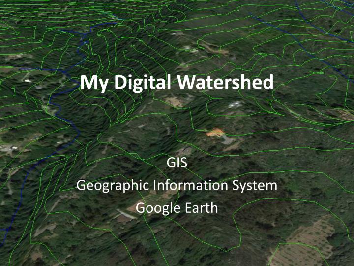
My Digital Watershed. GIS Geographic Information System Google Earth. Adding Layers (review). Go to http ://scwibles.ucsc.edu/Products/ProductsDocuments/Norris_ContourWhat_supporting /

E N D
My Digital Watershed GIS Geographic Information System Google Earth
Adding Layers (review) • Go to http://scwibles.ucsc.edu/Products/ProductsDocuments/Norris_ContourWhat_supporting/ • Download (right click) watsonville.kmz and choose “save link as” from the menu, navigate to the desktop and click ‘OK’ • From the file menu in Google earth open “watsonvill.kmz” from the Desktop • It will appear in the “Temporary Places” on the left
Which way does the water go?(review) Which direction does the river flow? • Where is the river? • Which direction does the river flow? http://www.cibolasar.org/minilessons/nav_lesson/USMC_mapfigs.jpg
Finding the Pinto Lake watershed • Double click the Watsonville folder on the left (under “Temporary Places”) • Find Pinto Lake and zoom in (double click on Pinto Lake) • Click the “+” or “-” icons on the slider next to the compass arrow until you see the lake and all the creeks that flow into it • How many rivers/creeks flow into Pinto Lake?
Drawing the Pinto watershed • Click the add polygon tool • Type “Pinto” as a name • DO NOT click OK and instead move the new window of to the side • Move the cursor to the bottom of Pinto Lake – note the cursor is now a “sight” The add polygon tool • – Use your knowledge of contours and watersheds to draw the watershed • – Click “OK” when you are finished, you should now see “Pinto” under “Temporary Places”
How big is the watershed? • Measuring area with Google Earth • Right Click your new “Pinto” polygon in the list of places • Choose “Save Place as” from the menu • Choose Desktop as the place • Choose Kml (*.kml) from the “Save as Type” menu • Leave the name as “Pinto.kml” • Click “OK” right click here
Measuring area on the Internet • Open a web browser (chrome, firefox, internet explorer) • Go to: http://extension.unh.edu/kmlTools/ • Click the “Choose File” button and choose your “Pinto.kml” file • Type “Pinto” in the Description box • Click the “Submit” button • When the new page loads click the “Area” button
Flight Simulator • Do you want to learn how to fly?? • Turn of “Temporary Places” (click the checkbox) • Go to “Tools” menu and choose “Enter Flight Simulator” • Click “SR22” (easier) • Click “Current View” • Click Start Flight (Good Luck!!!)
Airplane Controls • Arrows (aerolons and rudder) • Mouse click (arolons and rudder) • Page up – Page Down (throttle) • “F” – SHIFT “F” (flaps) • “,” (left brake) “.” (right brake)