Download
1 / 1
10 likes | 132 Views
20. 20. 100. 20. 20. 140. 100. 180. 60. 60. 300. 20. 20. 100. 140. 60. 20. 20. 60. 140. 220. Missoula flood deposits. Quaternary Geology and Geomorphology of the Willamette Basin, Western Oregon. Alluvium and basin-fill sediment. Prepared by: Ian Macnab

E N D
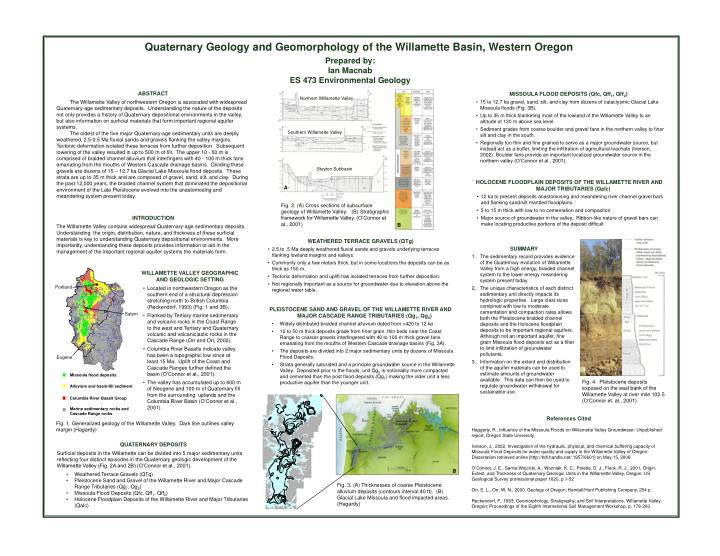
20 20 100 20 20 140 100 180 60 60 300 20 20 100 140 60 20 20 60 140 220 Missoula flood deposits Quaternary Geology and Geomorphology of the Willamette Basin, Western Oregon Alluvium and basin-fill sediment Prepared by: Ian Macnab ES 473 Environmental Geology Columbia River Basalt Group Marine sedimentary rocks and Cascade Range rocks ABSTRACT The Willamette Valley of northwestern Oregon is associated with widespread Quaternary-age sedimentary deposits. Understanding the nature of the deposits not only provides a history of Quaternary depositional environments in the valley, but also information on surficial materials that form important regional aquifer systems. The oldest of the five major Quaternary-age sedimentary units are deeply weathered, 2.5-0.5 Ma fluvial sands and gravels flanking the valley margins. Tectonic deformation isolated these terraces from further deposition. Subsequent lowering of the valley resulted in up to 500 m of fill. The upper 10 - 50 m is comprised of braided channel alluvium that interfingers with 40 - 100 m thick fans emanating from the mouths of Western Cascade drainage basins. Dividing these gravels are dozens of 15 – 12.7 ka Glacial Lake Missoula flood deposits. These strata are up to 35 m thick and are composed of gravel, sand, silt, and clay. During the past 12,000 years, the braided channel system that dominated the depositional environment of the Late Pleistocene evolved into the anastomosing and meandering system present today. • Missoula Flood Deposits (Qfc, Qff1, Qff2) • 15 to 12.7 ka gravel, sand, silt, and clay from dozens of cataclysmic Glacial Lake Missoula floods (Fig. 3B). • Up to 35 m thick blanketing most of the lowland of the Willamette Valley to an altitude of 120 m above sea level. • Sediment grades from coarse boulder and gravel fans in the northern valley to finer silt and clay in the south. • Regionally too thin and fine grained to serve as a major groundwater source, but instead act as a buffer, limiting the infiltration of agricultural leachate (Iverson, 2002). Boulder fans provide an important localized groundwater source in the northern valley (O’Connor et al., 2001). Northern Willamette Valley Southern Willamette Valley Stayton Subbasin • Holocene Floodplain Deposits of the Willamette River and Major Tributaries (Qalc) • 12 ka to present deposits anastomosing and meandering river channel gravel bars and flanking sand/silt mantled floodplains. • 5 to 15 m thick with low to no cementation and compaction • Major source of groundwater in the valley. Ribbon-like nature of gravel bars can make locating productive portions of the deposit difficult A Fig. 2. (A) Cross sections of subsurface geology of Willamette Valley. (B) Stratigraphic framework for Willamette Valley. (O’Connor et al., 2001) INTRODUCTION The Willamette Valley contains widespread Quaternary-age sedimentary deposits. Understanding the origin, distribution, nature, and thickness of these surficial materials is key to understanding Quaternary depositional environments. More importantly, understanding these deposits provides information to aid in the management of the important regional aquifer systems the materials form. B • Weathered Terrace gravels (qtg) • 2.5 to .5 Ma deeply weathered fluvial sands and gravels underlying terraces flanking lowland margins and valleys. • Commonly only a few meters thick, but in some locations the deposits can be as thick as 150 m. • Tectonic deformation and uplift has isolated terraces from further deposition. • Not regionally important as a source for groundwater due to elevation above the regional water table. • Summary • The sedimentary record provides evidence of the Quaternary evolution of Willamette Valley from a high energy, braided channel system to the lower energy meandering system present today. • The unique characteristics of each distinct sedimentary unit directly impacts its hydrologic properties. Large clast sizes combined with low to moderate cementation and compaction rates allows both the Pleistocene braided channel deposits and the Holocene floodplain deposits to be important regional aquifers. Although not an important aquifer, fine grain Missoula flood deposits act as a filter to limit infiltration of groundwater pollutants. • Information on the extent and distribution of the aquifer materials can be used to estimate amounts of groundwater available. This data can then be used to regulate groundwater withdrawal for sustainable use. • Willamette Valley GEOGRAPHIC AND GEOLOGIC SETTING • Located in northwestern Oregon as the southern end of a structural depression stretching north to British Columbia (Reckendorf, 1993) (Fig. 1 and 3B). • Flanked by Tertiary marine sedimentary and volcanic rocks in the Coast Range to the west and Tertiary and Quaternary volcanic and volcaniclastic rocks in the Cascade Range (Orr and Orr, 2000). • Columbia River Basalts indicate valley has been a topographic low since at least 15 Ma. Uplift of the Coast and Cascade Ranges further defined the basin (O’Connor et al., 2001). • The valley has accumulated up to 400 m of Neogene and 100 m of Quaternary fill from the surrounding uplands and the Columbia River Basin (O’Connor et al., 2001). Portland • PLEISTOCENE SAND AND GRAVEL OF THE WILLAMETTE RIVER AND MAJOR CASCADE RANGE TRIBUTARIES (Qg1, Qg2) • Widely distributed braided channel alluvium dated from >420 to 12 ka • 10 to 50 m thick deposits grade from finer grain, thin beds near the Coast Range to coarser gravels interfingered with 40 to 100 m thick gravel fans emanating from the mouths of Western Cascade drainage basins (Fig. 3A). • The deposits are divided into 2 major sedimentary units by dozens of Missoula Flood Deposits. • Strata generally saturated and a principle groundwater source in the Willamette Valley. Deposited prior to the floods, unit Qg2 is noticeably more compacted and cemented than the post flood deposits (Qg1) making the older unit a less productive aquifer than the younger unit. Salem Eugene Fig. 4. Pleistocene deposits exposed on the east bank of the Willamette Valley at river mile 102.5 (O’Connor et. al., 2001) References Cited Haggerty, R., Influence of the Missoula Floods on Willamette Valley Groundwater: Unpublished report, Oregon State University Iverson, J., 2002, Investigation of the hydraulic, physical, and chemical buffering capacity of Missoula Flood Deposits for water quality and supply in the Willamette Valley of Oregon: Dissertation retrieved online [http://hdl.handle.net/ 1957/6601] on May 15, 2008 O’Connor, J. E., Sarna-Wojcicki, A., Wozniak, K. C., Polette, D. J., Fleck, R. J., 2001, Origin, Extent, and Thickness of Quaternary Geologic Units in the Willamette Valley, Oregon: US Geological Survey professional paper 1620, p.1-52 Orr, E. L., Orr, W. N., 2000, Geology of Oregon: Kendall/Hunt Publishing Company, 254 p. Reckendorf, F., 1993, Geomorphology, Stratigraphy, and Soil Interpretations, Willamette Valley, Oregon: Proceedings of the Eighth International Soil Management Workshop, p. 178-200 Fig. 1. Generalized geology of the Willamette Valley. Dark line outlines valley margin (Hagardy) • QUATERNARY DEPOSITS • Surficial deposits in the Willamette can be divided into 5 major sedimentary units reflecting four distinct episodes in the Quaternary geologic development of the Willamette Valley (Fig. 2A and 2B) (O’Connor et al., 2001). • Weathered Terrace Gravels (QTg) • Pleistocene Sand and Gravel of the Willamette River and Major Cascade Range Tributaries (Qg1, Qg2) • Missoula Flood Deposits (Qfc, Qff1, Qff2) • Holocene Floodplain Deposits of the Willamette River and Major Tributaries (Qalc) B Fig. 3. (A) Thicknesses of coarse Pleistocene alluvium deposits (contours interval 40 ft). (B) Glacial Lake Missoula and flood impacted areas. (Hagardy) A