Download
1 / 68
690 likes | 788 Views
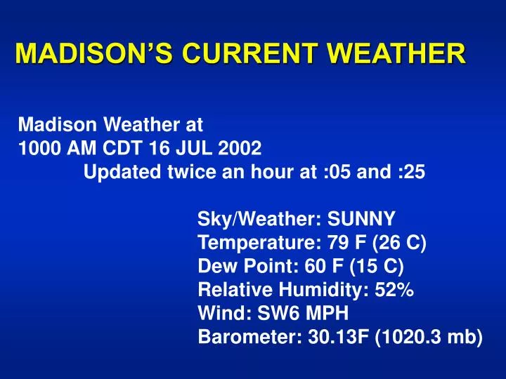
MADISON’S CURRENT WEATHER. Madison Weather at 1000 AM CDT 16 JUL 2002 Updated twice an hour at :05 and :25 Sky/Weather: SUNNY Temperature: 79 F (26 C)

E N D
MADISON’S CURRENT WEATHER Madison Weather at 1000 AM CDT 16 JUL 2002 Updated twice an hour at :05 and :25 Sky/Weather: SUNNY Temperature: 79 F (26 C) Dew Point: 60 F (15 C) Relative Humidity: 52% Wind: SW6 MPH Barometer: 30.13F (1020.3 mb)
T.S. Arthur Winds: 60 mph CURRENT VISIBLE
T.S. Arthur CURRENT IR
Current Surface Weather Map with Isobars (“iso” = equal & “bar” = weight), Fronts and Radar
Current Temperatures (°F) & Isotherms(“iso” = equal +”therm” = temperature)
IFR – Instrument Flight RulesRed Dots: Ceiling < 1000 ft or Visibility < 3 miles
Announcements • Homework #3 is due next Thurs. 18 July 2002 • If you have ??, please see me.
ATM OCN 100 - Summer 2002 LECTURE 12 CLOUD OBSERVATIONS & CLASSIFICATION • INTRODUCTION CLOUDS – SIGNPOSTS IN THE SKY • What can be learned from clouds? • Is it partly cloudy or partly sunny? • How are clouds classified?
CLOUDS - SIGNPOSTS IN THE SKY • Atmospheric moisture content; • Air temperatures aloft; • Atmospheric stability; • Tracer for winds aloft (speed & direction) and wind shear[speed/direction change with height].
B. OBSERVATIONAL MEASUREMENTS OF CLOUDS • Cloud Amount or Sky Cover • fraction of sky covered by a cloud; • based on visual estimates or measurements.
B. CLOUD OBSERVATIONS (con’t.) • Cloud Heights & Ceilings • Height of cloud base; • Based upon visual estimates or measurements.
C. CLOUD TYPES - CLOUD CLASSIFICATION SCHEME • Historical • Luke Howard in early 19th century. • Basis for Modern Traditional Cloud Classification Scheme • Appearance • Height
C. CLOUD CLASSIFICATION SCHEME (con’t.) • The Nature of Cloud Types • Layer or Stratiform Clouds • Layer forms indicate gentle uplift. • Heaped or Cumuliform Clouds • Puffy forms indicate vigorous uplift.
CLOUD TYPES [based upon International Cloud Atlas (WMO)]See Table 7.1 Moran & Morgan, 1997
HIGH CLOUDS > 20,000 ft (> 6 km) “Cold clouds” with ice crystalsSee Table 7.1 Moran & Morgan, 1997
Cirrostratus (Cs) Made of a thin, transparent layer of (all ice) high clouds. Halos are common with this cloud type.
Cirrocumulus (Cc) Note the clumpy rows – due to wind shear (also all ice)
MIDDLE CLOUDS 6500 to 20,000 ft (2 – 6 km) “Cold clouds” with supercooled water dropletsSee Table 7.1 Moran & Morgan, 1997
Altocumulus (Ac) Remember…cumulus means puffy. (Can be a mix of ice & water)
Altostratus (As) Another transparent layer….this one is at mid levels and can be made up of ice and water
LOW CLOUDS 0 – 6500 ft (0 – 2 km)“Warm clouds” with water dropletsSee Table 7.1 Moran & Morgan, 1997
Stratocumulus (Sc) (con’t.) Stratocumulus layers are thin, but can be extremely dense, as seen from above.
VERTICALLY DEVELOPED CLOUDS0 – 10,000 ft ( 0 – 3 km)See Table 7.1 Moran & Morgan, 1997
Cumulus (Fair Weather) (Cu) Note the puffiness of the clouds. Also, they are rather isolated, although it may not appear that way on the horizon.
Cumulonimbus (Cb) Approximate tropopause (~ 6 miles high) ANVIL RAIN SHAFT Notice the anvil aloft! This cloud is probably nearly 100 miles away. They are huge!!!