Download
1 / 12
120 likes | 249 Views
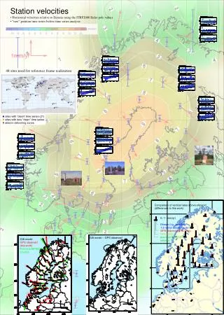
FORWARD AND INVERSE MODELLING OF GPS OBSERVATIONS OF FENNOSCANDIAN GIA. G.A. Milne 1 , J.X. Mitrovica 2 , H.-G. Scherneck 3 , J.L. Davis 4 , J.M. Johansson 3 , H. Koivula 5 , M. Vermeer 6. 1 Dept. of Geological Sciences, University of Durham, UK

E N D
FORWARD AND INVERSE MODELLING OF GPS OBSERVATIONS OF FENNOSCANDIAN GIA G.A. Milne1, J.X. Mitrovica2, H.-G. Scherneck3, J.L. Davis4, J.M. Johansson3, H. Koivula5, M. Vermeer6 1 Dept. of Geological Sciences, University of Durham, UK 2 Dept. of Physics, University of Toronto, Canada 3 Onsala Space Observatory, Sweden 4 Harvard-Smithsonian Center for Astrophysics, USA 5 Finish Geodetic Institute, Finland 6 Institute of Geodesy, Helsinki University of Technology, Finland
GIA MODEL Earth Rheology Earth Forcing Impulse response formalism Linear Maxwell rheology Compressible 1D structure Rotational potential Surface loading Euler equations Ocean Ice Sea-level equation ICE-3G(Tushingham & Peltier, 1991) FENN+BARENTS (Lambeck et al., 1998) • Time-dependent ocean function • Near-field water influx
Perez-Gussinye et al. (2004) Te (km)
SUMMARY • Data can provide useful information to constrain Fennoscandian ice history. • Viscosity inference relatively insensitive to adopted ice model. • Data capable of resolving two layers within upper mantle and one layer in lower mantle to a depth of ~1200 km. • Remaining residual signal to be explored via: • - Dynamic ice models • - Lateral earth structure • - Neotectonic motions