Download
1 / 1
10 likes | 130 Views
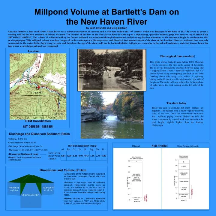
Location. 70.8mx9.75m x3.1m. 70.8mx9.75m x3.1m. 70.8mx8.5mx4.5m.

E N D
Location 70.8mx9.75m x3.1m 70.8mx9.75m x3.1m 70.8mx8.5mx4.5m Abstract: Bartlett’s dam on the New Haven River was a mixed construction of concrete and a crib dam built in the 19th century, which was destroyed in the flood of 1927. It served to power a working mill for the local residents of Bristol, Vermont. The location of the dam on the New Haven River is at the top of a high-energy, quartzite bedrock gorge that rests on top of Bristol Falls (18T 0656251 4887851.) The volume of sediment held by the former millpond was calculated through dimensional analysis using the dam abutments as the maximum height in combination with local topography. This millpond volume was then compared to the contemporary discharge rates and dissolved load measurements of the river at this location. However, sediment load was only measurable in the water during high energy events, and therefore, the age of the dam could not be back-calculated. Soil pits were also dug in the old mill sediments, and river terrace below the dam where a correlating paleosol was recognized. Millpond Volume at Bartlett’s Dam on the New Haven River by Zach Swander and Greg Baldwin The original dam (no date) This photo shows Bartlett’s dam before 1900. The dam is visible on top of the falls in the center of the photo. The river cuts through the quartzite bedrock gorge that is dipping North. There is riparian vegetation, but it is limited by the rocky outcropping, and lack of soil from flooding down this steep river valley. A spillway, piping, and mill shack are all visible on the right side of the photo. The main mill was believed to be located out of sight, above the rock outcrop on the left side of the dam. The dam today Today the dam is gone,but not many changes are apparent. The riparian zone is more vegetated on both sides of the river. Only the embankment structures and spillway piping remain. Below the falls the water is dammed by a small rock dam that raises the pool height slightly higher than the historic photograph. UTM Coordinates 18T 0656251 4887851 Discharge and Dissolved Sediment Rates • Velocity= 1.075 m/s • Cross-sectional area=8.32 m2 • Discharge (Area*Velocity)=8.94 m3/s • Manning’s n=.06=((.254)2/3 (.025)1/2)/1.075 • Dissolved Sediment Load Soil Profiles ICP Concentration (mg/L) Millpond River Terrace (all sand) • Result: Total Suspended Sediment =8,593 kg/day Dimensions and Volume of Dam • Dimensions of the millpond were calculated as three cubic rectangles. Two of which are of equal size. • Saltation is the major form of sediment transport. High-energy events, such as floods, are believed to be the main form of sediment transport. Local residents report 3-4 foot diameter boulders being moved during floods. • Result: Volume of Sediment Released from dam failures in 1927 and 1998 total= 3,494 m3. (sum of 3 dimensions in figure)