Download
1 / 22
220 likes | 340 Views
Gainesville Youth Center. University of Florida Department of Urban and Regional Planning URP 4273 Survey of Planning and Information Systems Spring 2003 Instructor: Juna Goda Papajorgji. Final Project Team. Team One Brian Pearson Carlos Perez Richard Rollins Daniel Sorrow.

E N D
Gainesville Youth Center • University of Florida • Department of Urban and Regional Planning • URP 4273 • Survey of Planning and Information Systems • Spring 2003 • Instructor: Juna Goda Papajorgji
Final Project Team • Team One • Brian Pearson • Carlos Perez • Richard Rollins • Daniel Sorrow
Project Objectives • Research Alachua County, Florida and specifically East Gainesville Using GIS to locate the ideal location for the Youth Center. • Select multiple ideal locations for the Community Youth Center in East Gainesville, based on opportunities and constraints.
Problem/ Justification Statement • Area is misused and dilapidated • Area is in the early stages of abandonment of homeowners and businesses • Area is surrounded with light industrial, institutional, open space, and low density residential districts
Site Overview • The proposed site location is between East Gainesville and Newnan's Lake.
Methodology Statement • Locate Youth Center near Residential Area, preferably High, Medium Density Residential. • Location that is easily accessible to School, and Residential Area’s. • Select a location that is near RTS Bus Stops and Routes.
Existing Overall Land Uses • There is no organizational development, method or strategy. All of these issues are contributing to sprawl. • Low Density Residential, Light Industrial, Institutional, and commercial are the main land uses.
Existing and Future Land Uses • This GIS map shows both existing land uses and Future land uses.
Natural Features • Hydrology- Showing the Rivers and Lakes. • Wetlands-Aquatic Natural Areas • Topography- Elevation Change’s shown in red.
Unbuildable Area’s • This area is based on GIS data collected to determine which area’s are unbuildable. • Area’s such as Preservation area’s, Conservation area’s, Wetlands, and Topography.
Residential Density and Institution Proximity • Area’s of both Low and Medium Density Residential are of significant importance. • There are three local schools within both walking distance and along local RTS bus routes.
Youth Center Location Synthesis Plan • This GIS map is a collection of all of the important layers that will have an effect on the site location.
Parcels and Lots • Various lot’s and parcel sizes are surrounded in blue. • The proposed Community Youth Center locations are surrounded in red.
Proposed Location One • This location is the first of three proposed areas for the Youth Recreation Center. • After a thorough review using GIS we found that this particular site is in a wetland with moderate topographic changes.
Proposed Location Two • This location is the second of four proposed areas for the Youth Recreation Center. This location is directly across from the school, therefore crosswalks will be needed. • This proposed site location is also in a wetland.
Proposed Location Three • This location is the third of four proposed areas for the Youth Recreation Center. This location is South of the school and off the road • The problem with this location is that it is in an area that is prone to flooding.
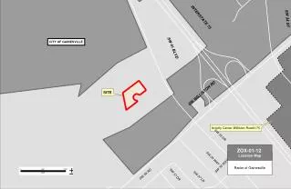
Proposed Location Four • This is the best location based off of information collected in G.I.S. The site is located in a low density residential area, surrounded by 27 RTS bus stops, preservation area’s and recreation open space area’s.
Final Site Location • After reviewing all of the data and all four possible site locations, we determined that the best location for the Community Youth Center is location four. • This location is within walking distance from the RTS bus stops, that run by all three local schools. • The site was chosen based on its Topography, Wetlands, Access, districts, and room for future development and growth.
Close-up of Proposed Youth Center Study Area • Site contains • Public open space • Low density residential • Commercial • Institutional • Agriculture/Rural
Conclusion • In conclusion, we have determined through research in ecology, economics, GIS and participatory planning that this location makes accessibility attractive and will not interfere with the experience of being in a natural setting.