Download
1 / 1
10 likes | 182 Views
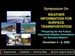
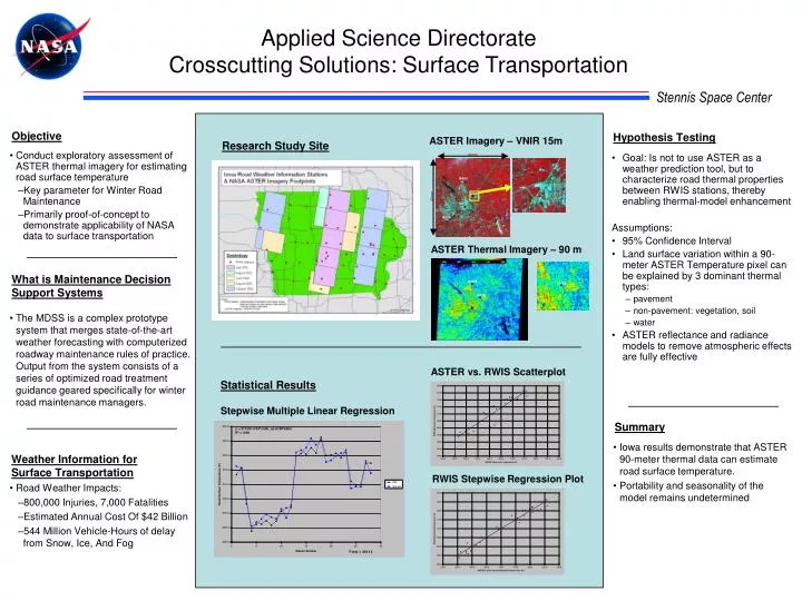
ASTER Imagery – VNIR 15m. Research Study Site. 60 km. y = 215.96 -0.54*solar_az+0.58*aster R 2 = 0.98. IA005. IA003. 60 km. IA017. IA016. ASTER Thermal Imagery – 90 m. IA005. IA003. IA003. IA017. Objective.

E N D
ASTER Imagery – VNIR 15m Research Study Site 60 km y = 215.96 -0.54*solar_az+0.58*aster R2 = 0.98 IA005 IA003 60 km IA017 IA016 ASTER Thermal Imagery – 90 m IA005 IA003 IA003 IA017 Objective • Conduct exploratory assessment of ASTER thermal imagery for estimating road surface temperature • Key parameter for Winter Road Maintenance • Primarily proof-of-concept to demonstrate applicability of NASA data to surface transportation F-test = 339.12 What is Maintenance Decision Support Systems • The MDSS is a complex prototype system that merges state-of-the-art weather forecasting with computerized roadway maintenance rules of practice. Output from the system consists of a series of optimized road treatment guidance geared specifically for winter road maintenance managers. Applied Science Directorate Crosscutting Solutions: Surface Transportation Weather Information for Surface Transportation Hypothesis Testing • Goal: Is not to use ASTER as a weather prediction tool, but to characterize road thermal properties between RWIS stations, thereby enabling thermal-model enhancement Assumptions: • 95% Confidence Interval • Land surface variation within a 90-meter ASTER Temperature pixel can be explained by 3 dominant thermal types: • pavement • non-pavement: vegetation, soil • water • ASTER reflectance and radiance models to remove atmospheric effects are fully effective ASTER vs. RWIS Scatterplot Statistical Results Stepwise Multiple Linear Regression Summary • Iowa results demonstrate that ASTER 90-meter thermal data can estimate road surface temperature. • Portability and seasonality of the model remains undetermined RWIS Stepwise Regression Plot • Road Weather Impacts: • 800,000 Injuries, 7,000 Fatalities • Estimated Annual Cost Of $42 Billion • 544 Million Vehicle-Hours of delay from Snow, Ice, And Fog