Download
1 / 18
180 likes | 195 Views
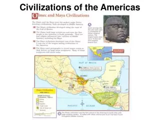
Ancient Civilizations of the Americas. Lecture 8: The Rise of Monte Alban in the Valley of Oaxaca. Zapotecs and Mixtecs Language: Otto-Manguean family Location: Mixtecs – Mixteca Alta (highlands), Nochixtl án Valley, Mixteca Baja, Mixteca de la Costa Zapotecs: Valley of Oaxaca.

E N D
Ancient Civilizations of the Americas Lecture 8: The Rise of Monte Alban in the Valley of Oaxaca
Zapotecs and Mixtecs Language: Otto-Manguean family Location: Mixtecs – Mixteca Alta (highlands), Nochixtlán Valley, Mixteca Baja, Mixteca de la Costa Zapotecs: Valley of Oaxaca
Apart from population increases during Monte Albán I: • Houses go from being built of wattle and cane to being built of adobe • People move into the risky piedmont zone and establish irrigation systems. • Ceramics go from being user-produced to being manufactured by specialists. • Comales are made and used for the first time.
Brief History of Investigations of Monte Albán • 1902 Leopoldo Batres excavates at Monte Albán and removes many of the Danzante slabs. • 1931-1949 Excavations carried out by Alfonso Caso, Ignacio Bernal, and Jorge Acosta • Opening of 170 tombs, reconstruction of many buildings. • 1971 Valley of Oaxaca Settlement Pattern Project initiated by Richard Blanton (student of Kent Flannery). Joined by Stephen Kowalewski and Gary Feinman. • Surveyed and mapped entire valley, produced numerous publications. • 1992-1994 Marcus Winter excavates at Monte Albán.
Late Monte Albán I. 350-200 BC Population at Monte Albán reaches 17,000 Hilltop is leveled Danzantes increases to 320 Work begins on a defensive wall surrounding Monte Albán
Monte Albán II 200 BC – AD 300 • The reach of Monte Albán extends beyond the Valley of Oaxaca – military outpost established 100 km to the north. • Entire top of Monte Albán is leveled. • Structure J established to commemorate military victories over named localities. • Ball court is added • Piedmont Zone is abandoned. • Secondary centers, such as San Jose Mogote, gain in population and elaboration
Reading: Year: 6 Turquoise Place Name Mountain/Place sign Inverted head Date: 11 Arrow Lápida 14: One of 40 “conquest slabs” set into Building J
Site of Loma de la Coyotera, 80 km northeast of Monte Albán is sacked and burned during Monte Albán II.. 61 skulls of the inhabitants were mounted on a rack.
Identification of conquered towns named in the Monte Albán conquest slabs
Kent Flannery and Joyce Marcus determined that Monte Albán had become a state during Monte Albán II. The Cloud People 1983 • Characteristics of a State • Full-time leaders not related to commoners. • 4 level administrative hierarchy. • Tax and tribute system • Professional army