Download
1 / 16
160 likes | 325 Views
Extended Semantic Web Conference 2012. Data models, Query Languages, Implemented Systems and Applications of Linked Geospatial Data. Manolis Koubarakis , Kostis Kyzirakos and Manos Karpathiotakis. Dept. of Informatics and Telecommunications

E N D
Extended Semantic Web Conference 2012 Data models, Query Languages, Implemented Systems and Applications of Linked Geospatial Data ManolisKoubarakis, KostisKyzirakos and Manos Karpathiotakis Dept. of Informatics and Telecommunications National and Kapodistrian University of Athens
Tutorial Organization • 14:00 – 14:15 Introduction • 14:15 – 15:00 Background in geospatial data modeling • 15:00 – 15:30 Geospatial data in the Semantic Web – stSPARQL • 15:30 – 16:00 Coffee break • 16:00- 16:30 Geospatial data in the Semantic Web – GeoSPARQL • 16:30 – 17:00 Implemented systems and applications • 17:00 – 17:15 Conclusions, questions, discussion • 17:15 – 17:30 Demo of Strabon 2
Extended Semantic Web Conference 2012 Introduction Presenter: ManolisKoubarakis
Outline • Why geospatial information? • Geographical Information Science and Systems • Why this tutorial? 4
Why Geospatial Information? • Geospatial, and in general geographical, informationis very important in reality: everything that happens, happens somewhere (location). • Decision making can be substantially improved if we know where things take place. 5
Geography • From http://en.wikipedia.org/wiki/Geography • Geography is the science that studies the lands, the features, the inhabitants and the phenomena of the Earth. • From the Greek word γεωγραφία (geographia) which means “describing the Earth”. 6
Geographical Information Systems and Science • A geographical information system (GIS) is a system designed to capture, store, manipulate, analyze, manage, and present all types of geographical data. • GIS science is the field of study for developing and using GIS. 7
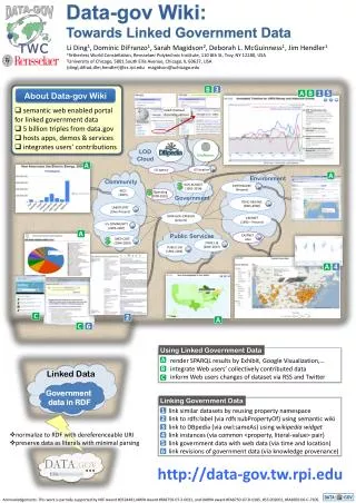
Why this tutorial? • Lots of geospatial data is available on the Web today. • Lots of public data coming out of open government initiatives is geospatial. • Lots of this public data is quickly being transformed into linked data! • People have started building applications utilizing linked data. 9
Conclusions • Introduction • Why geospatial information? • Geographical Information Science and Systems • Why this tutorial? • Next topic: Background in geospatial data modeling 16