Download
1 / 1
10 likes | 125 Views
Licenses Management. Consulting information. County of Pamplona Pilot : Underground Scenario Pilot Leader: Tracasa . Downloading information. Works management. Overview

E N D
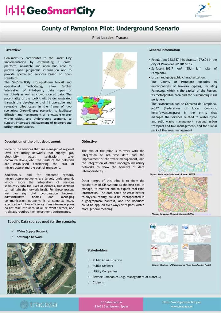
Licenses Management Consulting information County of Pamplona Pilot: Underground Scenario Pilot Leader: Tracasa Downloadinginformation Works management • Overview • GeoSmartCity contributes to the Smart City implementation by establishing a cross-platform, re-usable and open hub able to publish open geographic information and to provide specialized services based on open standards. • The GeoSmartCity cross-platform toolkit and operational methodology allow further integration of third-party data (open or restricted) as well as crowd-sourced data. The potentiality of the toolkit will be demonstrated through the development of 11 operative and re-usable pilot cases in the frame of two scenarios: Green-Energy scenario, to facilitate diffusion and management of renewable energy within cities, and Underground scenario, to support integrated management of underground utility infrastructures. • General Information • Population: 358.557 inhabitants, 197.604 in the city of Pamplona (01/01/2012 ) • Surface:1.305,7 km2 (25,1 km² city of Pamplona) • Urban and geographic characterization: • The County of Pamplona includes 50 municipalities of Navarra (Spain), including Pamplona, which is the capital of the Region, its metropolitan area and the surrounding rural periphery. • The “Mancomunidad de Comarca de Pamplona, MCA” (Federation of Local Councils; http://www.mcp.es) is the entity that manages the services related to water cycle and solid waste management, regional urban transport and taxi management, and the fluvial park of the area management. Description of the pilot deployment: Some of the services that are managed at regional level are utility networks that supply: gas, electricity, water, sanitation, tele-communications, etc. The limits of the networks are established considering the cost of infrastructure and the cost of manage it. Additionally, and for different reasons, infrastructure networks are largely underground, which favors the integration of services seamlessly into the lives of citizens, but difficult to maintain the network itself. For these reasons we can say that coordination between administrative bodies and managing communication networks is a complex issue, executed with low efficiency if maintenance plans do not take into account all relevant factors, and it always requires high investment performance. Objective The aim of the pilot is to work with the integration of real-time data and the improvement of the water management, and the integration of other underground utility networks to show the benefits of data interoperability. Other target of this pilot is to show the capabilities of GIS systems as the best tool to manage, to monitor and to exploit real-time information. The data could be cross nearer to physical reality, could be interoperated in a geographical context, and the decisions could be applied over ways or regions with a more general meaning. Figure: Water supply Network. Source: IDENA. Idena.navarra.es Figure: Sewerage Network. Source: IDENA. Idena.navarra.es • Specific Data sources used for the scenario: • Water Supply Network • Sewerage Network • Stakeholders • Public Administration • Public Officers • Utility Companies • Service Companies (e.g. management of water...) • Citizens Figure: Modules of Underground Pipes Coordination Portal C/ Cabárceno 6 31621 Sarriguren, Spain http://www.geosmartcity.eu www.tracasa.es