Download
1 / 6
70 likes | 281 Views
Earthquake Hazards. Landslides, Liquefaction, Dam Failure, Ground Rupture and Structural Collapse. Landslides.

E N D
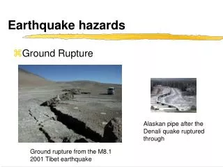
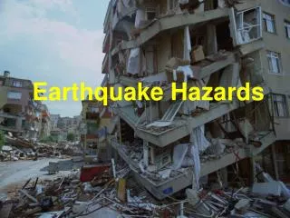
Earthquake Hazards Landslides, Liquefaction, Dam Failure, Ground Rupture and Structural Collapse
Landslides • There are many historical accounts of landslides and debris avalanches resulting from earthquakes. And indeed, these effects may be the most common and hazardous results of earthquakes In 1970, an earthquake-induced rock and snow avalanche on Mt. Huascaran, Peru, buried the towns of Yungay and Ranrahirca. The total death toll was 66,700. The avalanche swept down slope about 14.4 km (9 mi) to Yungay at an average speed of over 160 km (100 mi) an hour. It is estimated to have consisted of about 2,200,000 m3 (80,000,000 ft3) of water, mud, and rocks.
This figure below shows a view of the landslides along Highway 18 that connects Redlands to Big Bear in the San Bernardino Mountains. The strong shaking also caused landslides to occur along Highway 38. The steep slopes are white in color because of the white decomposed granite soil. Big boulders were embedded in the soil covered slopes. The dust clouds created by the landslides were similar to smoke clouds from forest fires. People thought that forest fires were occurring. Above: Earthquake-induced slide and alluvial fan on downstream side of Madison River, Montana. Light colored rock is dolomite marble, the more resistant rock that supported weathered, mica-rich, overlying layers. An earthquake in 1959 fractured this dolomite and caused a great avalanche of rock, dirt, and trees to cascade from the steep south wall of the Madison River Canyon, about 394 m (1,300 ft) above the canyon floor. The avalanche formed a barrier 60.6 to 121.2 m (200 to 400 ft) high that completely blocked the gorge and the flow of the Madison River and created a lake. Twenty-eight people were believed to have been engulfed in the 88,000 kg (80 million ton) slide.
This view shows the boulder itself. This view shows the ridge where the boulder was located prior to its fall. This view shows a portion of the boulder's path through the forest. Several huge boulders reportedly bounded down Yucaipa Ridge above Forest Falls. One large boulder crashed down the hillside, mowing down tall cedars in its path. The boulder, the size of a small garage and measuring 16 ft by 16 ft by 14 ft, came to rest about 20 yards behind the Clarke residence on Prospect Drive in the western edge of Forest Falls. The boulder was estimated to have descended 1,000 feet vertically and covered a horizontal distance of 1,000 feet. It was said to be airborne most of the way as it hit the ground only three times on the way down.
Left: Earthquake of April 24, 1984, Morgan Hill, California. This magnitude 6.2 earthquake caused $30 million in property damage in northern California. The earthquake was felt over an area of 120,000 km2 in California and western Nevada. A landslide blocked the highway and bridge on Dunne Avenue at the east side of Cochrane Bridge. The bridge on East Dunne Avenue over Anderson Reservoir (about 7.2 km east of Morgan Hill) was closed to traffic due to a rock slide and major structural damage. Right: Earthquake of July 8, 1986, Palm Springs, California. The magnitude 6.0 earthquake caused $4.5 million in property damage and injured at least 29 people. Landslides occurred in the area. The shock was felt throughout much of southern California and in Las Vegas, Nevada, Lake Havasu City, Arizona and in the northern Baja California area of the United States and Mexico. A rockfall and debris slide has partially blocked the highway.
Landslide potential due to seismic shaking is well known based on slope steepness and past history. The blue areas on this map indicate areas prone to landslide activity during strong shaking. This map of the Laguna Beach area is from the California Division of Mines and Geology (CDMG) Seismic Hazards Mapping Program.