Download
1 / 14
140 likes | 251 Views
Meteorology and Hydrology in Yosemite National Park: A Sensor Network Application. Authors Jessica D Lundquist Daniel R Cayan Michael D Dettinger Presented By Ram. Motivation.

E N D
Meteorology and Hydrology in Yosemite National Park: • A Sensor Network Application.Authors • Jessica D Lundquist • Daniel R Cayan • Michael D Dettinger • Presented By Ram
Motivation • Snowmelt of Sierra Nevada is California’s major water resource. • These rivers act as Vital Arteries in the area. • Current streamflow measurements predict earlier snowmelt and increased global warming. • Existing models also predict a change in the average rainfall in the area. • Sparse data exist to predict and understand such changes.
Introduction • Objective • To use sensor networks efficiently for river monitoring and gauging meteorological processes at the snowmelt dominated Sierra Nevada Ranges for intelligent management of water resources. • To deploy a prototype sensor network at the Yosemite National Park to study and monitor such processes.
Why Sensor Networks • Challenges of Existing Monitoring Systems. • Access only to lowly elevated regions while the major hydrological processes happen at higher altitudes. • Snow accumulated at one place not a representative of the snow fall in the entire terrain region because snow occurs in patches of nonuniform depth and intensity. • Satellite images are infrequent. • Also satellite images do not help in understanding the actual river discharge.
Why Sensor Networks • Challenges of Existing Monitoring Systems. • Data Collection in High elevation Wilderness areas are difficult and expensive because of the extra costs and logistics required to visit snowy sites and preserve their undisturbed character. • Administrative problems limit access to these areas.
Sensor Networking at Yosemite National Park • Easy Access to Merced and Tuolumne Rivers in Yosemite National Park. • These rivers drain the western slope of the southern Sierra from altitudes of 1200 m to 3700 m. • Close to Highway 120(Tioga Road). • Unimpaired flows • Representative of basins throughout the Western United States.
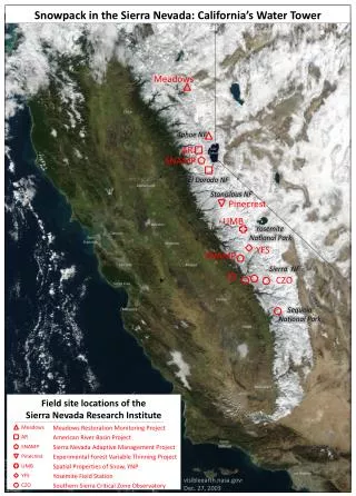
Sensor Networking at Yosemite National Park • River Monitoring network started in Summer 2001. • Twenty instruments recording hourly water level and temperature installed in the upper reaches of the rivers. • Sensor locations selected to monitor subbasins with a variety of topographic conditions. • Four water conductivity sensors deployed to make hourly measurements in the river basins. • Presently 25 internally-recording temperature/relative humidity sensors deployed along Highway 120 that monitors weather systems and air masses sweeping across the Sierra from the Pacific.
Sensor Networking at Yosemite National Park • Future Installments • Installation of webcam to view snow in surrounding alpine areas. • Installation of a full snow/meteorological station at • Merced Lake with GOES satellite telemetry.
Sensor Networking at Yosemite National Park • Communication Issues • Possible communication options are satellite uplink, wirelessly transmitting the data to a cell phone network , wirelessly transmitting the data to an installed equipment and then using landline communication from there on. • Data backup is important due to difficulty in geographical access. • The SIO Development Engineer Douglas Alden is building a low cost , low power data logger that will log , record and wirelessly transmit data from the sensors
Sensor Networking at Yosemite National Park • Data Logger Features • Small Battery pack. • 32 MB of memory. • Measurements at 3 minute intervals.
Sensor Networking at Yosemite National Park Thank You !