Download

1 / 31
310 likes | 493 Views
Volcanic Ash Remote Sensing at NOAA/NESDIS/STAR and CIMSS. Mike Pavolonis (NOAA/NESDIS/STAR) Justin Sieglaff and Wayne Feltz (CIMSS). Outline. Historical overview of volcanic ash support at CIMSS and NOAA/NESDIS/STAR - NASA ASAP’s role Recent NOAA/CIMSS research Future outlook. Outline.

E N D
Volcanic Ash Remote Sensing at NOAA/NESDIS/STAR and CIMSS Mike Pavolonis (NOAA/NESDIS/STAR) Justin Sieglaff and Wayne Feltz (CIMSS)
Outline • Historical overview of volcanic ash support at CIMSS and NOAA/NESDIS/STAR - NASA ASAP’s role • Recent NOAA/CIMSS research • Future outlook
Outline • Historical overview of volcanic ash support at CIMSS and NOAA/NESDIS/STAR - NASA ASAP’s role • Recent NOAA/CIMSS research • Future outlook
NASA ASAP Supported Volcanic Ash Research at CIMSS • The NASA ASAP provided the resources needed for CIMSS researchers to apply their expertise in [meteorological] cloud remote sensing to volcanic clouds. • Under NASA ASAP funding at CIMSS, the ash detection and height problems were studied (2003 - 2005).
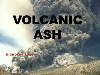
Ash Heights Mike Richards’ M.S. research was focused on using MODIS to infer ash heights. Volcanic clouds
Ash Detection Pavolonis et al. (2006) published an article on improvements in ash cloud detection. The goal was to develop an operational quality algorithm that can be used to automatically alert an analyst to the presence of a volcanic cloud.
NASA ASAP Supported Volcanic Ash Research at CIMSS • Research progress under the ASAP project paved the way for new funding opportunities from NOAA/NESDIS to implement the algorithms on a variety of current and future operational sensors and transition them to operations. • In 2005, M. Pavolonis began working for NOAA/NESDIS/STAR which helped to strengthen the relationship between research and NOAA/NESDIS operations.
Current NOAA Operational Volcanic Cloud Products Enhanced multi-spectral volcanic ash imagery **OMI SO2 images are being produced on an experimental basis (soon to be operational). Ellrod et al., 2004
NOAA/NESDIS/STAR Research to Operations Efforts • Thanks to the efforts of Gary Ellrod, Don Hillger, and others at CIRA, special imagery for monitoring volcanic ash clouds is available in NOAA operations. • While these products have proven to be very useful to volcanic ash forecasters, quantitative (e.g. ash probability, height, and mass loading) products are still lacking in operations. • As such, NOAA has funded two additional projects aimed at improving operational products produced by current operational sensors. • NOAA Product Systems Development and Implementation (PSDI) funding is supporting the implementation of an automated AVHRR based volcanic ash monitoring system. • NOAA GOES Improved Measurements and Product Assurance Plan (GIMPAP) funds are being used to develop quantitative volcanic ash products for the current GOES Imager.
NOAA’s Efforts for Future GOES • In 2006, the GOES-R Algorithm Working Group (AWG) Aviation Application Team formed. • Ken Pryor (Co-chair, microburst potential) • Wayne Feltz (Co-chair, turbulence and overshooting tops) • Bill Smith Jr. (icing) • John Mecikalski (CI) • Mike Pavolonis (volcanic ash, SO2, and fog) • The GOES-R requirements state that quantitative volcanic ash and SO2 products, in the form of ash height and mass loading and an SO2 mask, must be produced. • NOAA has funded Pavolonis and CIMSS colleagues to do this work.
Outline • Historical overview of volcanic ash support at CIMSS and NOAA/NESDIS/STAR - NASA ASAP’s role • Recent NOAA/CIMSS research • Future outlook
Remote Sensing Philosophy • Strive for globally and temporally consistent results (avoid regional and seasonal tuning, if possible). • Accounting for the background conditions on a pixel-by-pixel basis greatly improves the chance of producing globally consistent results. • The advent of more accurate fast RT models, higher quality NWP data, surface emissivity databases, and faster computers allows us to calculate a reasonable estimate of the clear sky radiance for each pixel. • We also seek IR-only approached when possible. • Avoid approaches that require extensive tuning when applied to various sensors with similar spectral channels. • Since cloud transmittance varies gradually as a function of wavelength compared to gasous transmittance, explicitly accounting for the spectral response function (assumed to be known) of a given band increases the chance of consistent results across a variety of sensors.
How often does BTD(11 - 12 um) go negative? Traditional ash detection methods trigger numerous false alarms Pavolonis et al. (2006), JTECH
How often does BTD(11 - 12 um) go negative? Traditional ash detection methods trigger numerous false alarms Algorithms should account for local background conditions Pavolonis et al. (2006), JTECH
Physical Relationships After Van de Hulst (1980) and Parol at al. (1991)… Effective absorption ratios (similar to ratio of scaled absorption cloud optical depth)
Physical Relationships • The bottom line is that the cloud microphysical signal can be isolated from the surface and atmospheric contribution by converting the measured radiances to effective absorption optical depth and examining the spectral variation. • This new data space allows us to largely avoid algorithm tuning and helps produce results that are much more spatially and temporally consistent. After Van de Hulst (1980) and Parol at al. (1991)… Effective absorption ratios (similar to ratio of scaled absorption cloud optical depth)
GOES-R AWG Efforts • Project Goal: Develop, implement, validate, and document volcanic ash and SO2 algorithms for the GOES-R Advanced Baseline Imager. • Products produced: ash probability, ash height, and mass loading
Meteo Clouds Ash BTD’s Beta Max Skill:0.82 Max Skill:0.72 Volcanic Ash Detection Potential volcanic ash pixels are identified using a tri-spectral (8.5, 11, and 12 um) optical depth ratio approach. Using optical depth ratios results in a 10% increase in skill in correctly identifying volcanic ash clouds compared to BTD’s! <Project> Critical Design Review
GOES-R Examples Karthala - 11/25/2005 Mount Etna - 11/24/2006 RGB Ash Detection Ash Height Ash Loading <Project> Critical Design Review
Algorithm Development - Performance Estimates • The ash detection algorithm is applied to every pixel in the full disk. • The height and mass loading retrieval is only applied to pixels that potentially contain ash so as to prevent a non-volcanic ash pixel from being assigned a non-zero mass loading. • Currently, the false alarm rate is on the order of 0.001%. Karthala ash cloud <Project> Critical Design Review
Difficult Scenes Ash over low cloud Since volcanic ash monitoring is vital, an effort is made to account for various conditions, including ash overlapping a lower cloud layer.
GOES-R SO2 Detection • SO2 clouds exhibit both an SO2 absorption and a small particle signature in the 7.3, 8.5, 11, and 12 m bands. • Thus, SO2 clouds that contain ice/water can be inferred using the split-window, even though the split window lacks SO2 absorption.
Algorithm Development for the Current GOES Imager • Project Goal: Apply modified versions of the GOES-R algorithms to the current series of GOES imagers. Once algorithms are deemed reliable, pursue a transition to operations. • Products produced: ash probability, ash height, and mass loading
Example GOES-10 Products (May 6, 2008) Ash Detection Theory RGB (Chaiten eruption) Mass Loading Ash Cloud Height
Operational Implementation of AVHRR Volcanic Ash Products • Project Goal: Implement volcanic ash algorithms in an operational AVHRR processing system (CLAVR-x), test in pre-operational mode (1/2009 - 1/2010), and begin operational processing (3/2010). • Products produced: ash probability, ash height, and mass loading
Expected Outcomes • After each AVHRR data segment is processed, the output is checked for high probability ash. If present, an email alert will be sent to VAAC analysts. • All products will also be viewable in McIDAS and AWIPS. • We are working closely with the Washington, D.C. VAAC on this project. We also hope engage the Anchorage VAAC.
Hyperspectral Infrared • Hyperspectral measurements offer improved sensitivity to the presence of ash and its height. • We are working towards routine hyperspectral processing (IASI and AIRS).
Outline • Historical overview of volcanic ash support at CIMSS and NOAA/NESDIS/STAR - NASA ASAP’s role • Recent NOAA/CIMSS research • Future outlook
Future Outlook • The ultimate goal is an automated multi-sensor global monitoring system (GEO’s and LEO’s) to assist volcanic ash forecasters. We can process any GEO imager, AVHRR, and MODIS. • Make better use of hyperspectral infrared measurements (e.g. combined imager/sounder retrievals for the best of both worlds). • Can satellite-based retrievals be assimilated into dispersion models? • Build collaborations (NRL, VAAC’s, NCAR, etc…) • Use current NASA ASAP volcanic ash funding to facilitate collaboration with NRL.
From David Innes From: FAA Aviation Safety Journal Vol. 2 (3)
ABI Current Spectral Coverage 16 bands 5 bands Spatial resolution 0.64 mm Visible 0.5 km Approx. 1 km Other Visible/near-IR 1.0 km n/a Bands (>2 mm) 2 km Approx. 4 km Spatial coverage Full disk 4 per hour Every 3 hours CONUS 12 per hour ~4 per hour Mesoscale Every 30 sec n/a Visible (reflective bands) On-orbit calibrationYes No The Advanced Baseline Imager: Slide courtesy of Tim Schmit