Download
1 / 16
160 likes | 407 Views
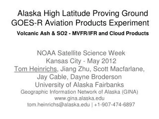
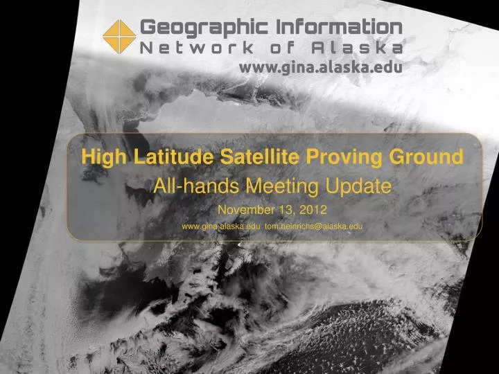
High Latitude Satellite Proving Ground All-hands Meeting Update November 13, 2012 www.gina.alaska.edu tom.heinrichs@alaska.edu. NPP Day Night Band Mosaic October 2012. Suomi NPP - Day Night Band October 30, 2012 - 7:46AM AKDT. North slope seen through cloud cover.

E N D
High Latitude Satellite Proving Ground All-hands Meeting Update November 13, 2012 www.gina.alaska.edu tom.heinrichs@alaska.edu
Suomi NPP - Day Night Band October 30, 2012 - 7:46AM AKDT
Arctic Ocean sea ice forming near the North Pole Sea ice in the visible spectrum in the dark months Suomi NPP DNB - October 30, 2012
Sounder Data Assimilation • AIRS, CrIS, and ATMS assimilation into regional WRF model (GINA-WRF) • In partnership with NWS and WRF modelling community at UAF. Suomi NPP CrIS and the Aqua AIRS instruments http://cimss.ssec.wisc.edu/goes/blog/archives/date/2012/06/29 (image courtesy of Joleen Feltz)
More Blogging http://uafgina.tumblr.com/
Visiting Scientists - STAR & CIMSS • Mike Pavolonis and Corey Calvert September 10-14, 2012 • Installed updated GEOCAT volash and fog/cloud software in Fairbanks • Met and worked with UAF research community • Trained 19 forecasters in Fairbanks and Anchorage (WFOs, AAWU, and CWSU) • Visited NESDIS Gilmore Creek facility • Success: excellent outreach to NWS & UAF and GEOCAT software & flow streamlined
Visiting Scientist - CIRA • Steve Miller October 2-4, 2012 • Installed updated DNB software in Fairbanks • Gave seminar; met and worked with UAF research community • Worked with Fairbanks NWS WFO • Visited NESDIS Gilmore Creek facility • Success: excellent outreach to NWS & UAF and DNB software & flow streamlined
Assembling Snow Hydrology Data from High Altitude Watersheds for Use in Climate Change Models Applied to Hydropower Forecasting in South Central and Southeast Alaska; a Proposed PhD Project Molly Tedesche, MS and Dr. Jessica Cherry, IARC/INE, UAF NWS Weather Station Network • Collaboration of UAF, the National Weather Service’s (NWS) Alaska-Pacific River Forecast Center (RFC), the USDA NRCS Snow monitoring program, and the National Operational Hydrologic Remote Sensing Center. • Explore satellite-based snow products (such as MODIS snow-covered area) to make statistical comparisons with in-situ and airborne datasets, as part of the NESDIS High Latitude GOES-R Proving Ground project. • Investigate how snow hydrology data might be affected by measurement resolution and method. • Test various interpolation techniques in an attempt to translate airport observations from existing low elevation weather stations into potential weather patterns in higher elevation mountain watersheds surrounding these airports in several South East Alaska (SEAK) and South Central AK communities. • The NWS RFC has very little weather station input for use in snowmelt and flood forecasting models, since these stations exist primarily at low elevation airports. • Currently in Northern SEAK, the only NRCS SNOTEL sites and Snow Courses are near Skagway, AK and Juneau, AK; leaving the majority of SEAK unmonitored by either real time NRCS infrastructure or in-situ measurements. • In Prince William Sound and on the Kenai Peninsula, the NRCS network is slightly more robust, though still limited. Real time SNOTEL sites, as well as Snow Courses, exist near Valdez, Glen Allen, Cordova, Moose Pass, Seward, Cooper Landing, Kenai Fjords National Park, and Homer. Map taken from www.nohrsc.noaa.gov NRCS SNOTEL & Snow Course Network NWS NOHRSC has very limited airborne datasets in these areas of Alaska. Flight lines primarily lie over South Central AK (Prince William Sound and Kenai Peninsula), leaving SEAK unmonitored possibly because of the extreme terrain of SEAK. Maps taken from www.ak.nrcs.usda.gov/snow
Solidifying Operations • Making GINA interactions with NWS more robust is a task in both our GOES-R and JPSS work on the High Latitude PG • LDM; NWAVE; IT Staff • NWS is updating network configuration to enhance transfer of HLPG products to FOs • shaving time off delivery; documenting data flows; identifying bottlenecks
Thank you Terra MODIS Nov. 2, 2012