Download
1 / 31
310 likes | 409 Views
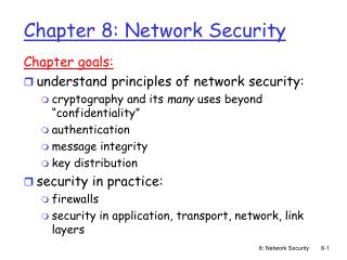
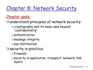
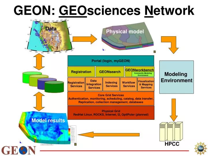
Portal (login, myGEON). Registration. GEONsearch. GEONworkbench. Community Modeling Environment. Indexing Services. Data Integration Services. Workflow Services. Registration Services. Visualization & Mapping Services. Core Grid Services

E N D
Portal (login, myGEON) Registration GEONsearch GEONworkbench Community Modeling Environment Indexing Services Data Integration Services Workflow Services Registration Services Visualization & Mapping Services Core Grid Services Authentication, monitoring, scheduling, catalog, data transfer, Replication, collection management, databases Physical Grid RedHat Linux, ROCKS, Internet, I2, OptIPuter (planned) GEON: GEOsciences Network Data Physical model Modeling Environment Model results HPCC
Agenda • Scientific Framework: Integration Scenarios • IT Advances • Data and Modeling - Scientific Advances • Educational Leadership • Social Aspects of Large Projects • Summary and Plans
Snapshot of the Day • GEON research and education activities: • Highlights given in talks • Some details provided in posters • Presentations available at the end of the day • GEON infrastructure and applications: mostly prototypes
Ramon Arrowsmith Arizona State University Chaitan Baru San Diego Supercomputer Center / University of California, San Diego Maria Luisa Crawford Bryn Mawr College Karl Flessa University of Arizona Randy Keller University of Texas at El Paso Mian Liu University of Missouri, Columbia Chuck Meertens UNAVCO, Inc. John Oldow University of Idaho Dogan Seber San Diego Supercomputer Center / University of California, San Diego Paul Sikora University of Utah Krishna Sinha Virginia Tech GEON Principal Investigators
GEON Mission and Goals “Enabling scientific discoveries and improving education in Earth Sciences through information technology research.” • Develop cyberinfrastructure for Geoscience research • Integrate, analyze and model 4-D data • Research and development in data integration systems, computing environments, and ontologic frameworks • Facilitate knowledge discovery for the geosciences • Promote leadership within geoscience education reform • Revolutionize how earth scientists do their science • democratize access to services and data • allow on-line replication of results • increase awareness of scientific knowledge “pathways” • Facilitate a cultural change
Challenges Many databases and models: • Interpretations limited by existing knowledge • Capture of concepts and relationships needed for computational tractability Creation of community knowledge base: • Required to support knowledge discovery • Assists in hypothesis generation
The Pathway…Partnership with Information Technology • Access /share data and products • Access /develop smart tools • Access computational resources • Access/apply knowledge management • Preserve data • Become educational leaders GEON supports such activities
Access to data representing scales of phenomenon and processes will be available within the infrastructure for discovering new knowledge (remember EarthScope) Surface geology Distribution of faults and earthquakes in mid-Atlantic region Cratonal lithosphere Deep mantle Lithosphere thickness (schematic) based on Zoback and Mooney (2003), Geologic Map ( USGS), fault distribution from Sinha (unpubl.)
GEON TestbedScience Themes DYSCERN
CRUSTAL EVOLUTION: ANATOMY OF AN OROGEN The Appalachian Orogen is a continental scale mountain belt that provides a geologic template to examine the growth and breakup of continents through plate tectonic processes .
First Order Science Question:What is the geologic history of accretionary orogens ? Role of accretionary orogens in the growth of continents 1. Major site of juvenile continental crust production at convergent plate margins 2. Addition of crust through accretion (terranes) 3. Recycling of continental and oceanic crust The Appalachian orogen provides a natural laboratory to develop methods for integration of data, tools and models with an emphasis on 4-D management of data and knowledge
Geologic phenomena Assembly and dispersal of super-continents: Rodinia , the Grenville record Neo-Proterozoic failed rift : testing multiple hypotheses Successful rifting of Rodinia: rift to drift transition Collisional events: representing an orogenic cycle Successful rifting : present configuration Research tasks to represent and interpret phenomenon Representing paleo-geography of plates Developing process ontology for hypothesis evaluation Integration of disciplinary databases through developing schemas and object ontology research Present day properties Appalachian Mountains: Recording 1000 Ma Of Earth History
Diversity Of Geologic Information Required To Analyze Crustal Evolution GEOLOGIC MAPS METAMORPHISM IGNEOUSACTIVITY GEODYNAMIC MODELING TIME STRATIGRAPHY/ SEDIMENTOLOGY PLATE CONFIGURATION STRUCTURE GEOPHYSICS
From schemas to ontologies to integration Virginia Tech research activities • Spatial distribution of igneous rocks: provide access to geologic maps at multiple scales • Capture igneous rock properties data in a digital format (database schema) • Provide web based tools • Develop discipline ontologies • Implement integration scenarios through ontologies • Shared educational opportunities (cs & geo graduate research)
The rock record preserves processes associated with crustal evolution of continents
Access, analysis and modeling of the igneous rock record is a pre-requisite for understanding crustal evolution through time-space
Scales of georeferenced observations contained in Virginia Tech database: facilitating analysis of orogens
Conceptual Model for Igneous Rock Properties (static) and Genesis (dynamic)
Design/Information Flow for Analysis of Igneous Rocks SchemaDevelopment
Components of the Virginia Tech field based schema: deploying data across multiple scales of observation and analysis
Design/Information Flow for Analysis of Igneous Rocks Ontology Development
Results of query displayed geographically and used in spatial analysesof terranes Prototype web based access and application of tools Based on SDSC (KR research group)
Query results displayed in tables and in classification diagrams Point-in-polygon routine classifies sample as Chrysolite. Sample can now participate in additional ontologically-driven comparative, statistical and data mining analyses. Based on SDSC (KR research group)
Design and Information Flow for Analysis of Igneous Rocks Tool Development
Ontology Driven Data Mining GEOROC : UNIQUE DATABASE FOR DATA MINING RESEARCH • Create reusable “Knowledge Base” • Iterate over experiment to refine the knowledge base • Minimize data handling/Maximize research • Allow different levels of knowledge discovery: Hidden, Deep • Adapted from Ramachandran, (2003)
Ontology Driven Data Mining • Ontology assists in structuring the data • Data sets associated with concepts in ontology • User navigates ontology to choose data sets • Helps to apply data mining at different levels of abstraction • Spatial and temporal variables are represented in the data
domain knowledge ? Information Integration Knowledge Representation: ontologies, concept spaces Database mediation Data modeling raw data Problem: Scientific Data Integration... fromQuestions to Queries ... What is the distribution and U/ Pb zircon ages of A-type plutons in VA? How about their 3-D geometry ? How does it relate to host rock structures? “Complex Multiple-Worlds” Mediation GeoPhysical (gravity contours) Geologic Map (Virginia) GeoChronologic (Concordia) Foliation Map (structure DB) GeoChemical (From Ludaescher, SDSC)