Download

1 / 22
220 likes | 298 Views
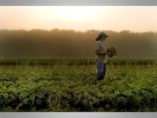
Utilization of GPS Based Technology in Row Crop Research and Bulk Production at the Davis Purdue Ag Center. 6230 N State Road 1 Farmland, IN 47340 765-468-7022 www.agriculture.purdue.edu/pac/davis/index.html. One of 8 Ag Centers in Indiana 623 acres – 450 Tillable Corn, Soybeans, Wheat

E N D
Utilization of GPS Based Technology in Row Crop Research and Bulk Production at the Davis Purdue Ag Center 6230 N State Road 1 Farmland, IN 47340 765-468-7022 www.agriculture.purdue.edu/pac/davis/index.html
One of 8 Ag Centers in Indiana • 623 acres – 450 Tillable • Corn, Soybeans, Wheat • Emphasis on Site Specific Ag • Long Term Timber Management • and Genetic Research
Davis Purdue Ag Center (DPAC) 1917 2011 • Gift from Martha Davis in 1917 • Given in memory of her son Herbert Davis • Original gift was 385 acres • DPAC Expanded to Current Size in 1960s • Horses, Beef Cattle, Dairy Cattle • Hog Operation Phased Out in late-1990s • Row Crops
Traditional Small Plot Research No Plot Equipment 2 ½ hours from Purdue Campus Heavy Clay, Poorly Drained, Variable Soils Most Fields – 30 acres in size Not Suitable for Small Plots
Utilization of GPS Technology at DPAC • Development of Field Scale Plot System • 1995 • Ag Leader AL2000 with FM DGPS • No Software on farm • 1996 – 1997 • AL2000 & Rockwell Vision System • Omni Star GPS Receiver with Satellite • DGPS • Logged data on VCD & Exported data • as CSV files • Kawasaki Mule for mapping & soil sampling • 1998 – 2000 • Switched to elevator side mount moisture sensor • Grid Soil Sampling and VRT applications of P&K • HP Palmtop computer and pocket excel for scouting • Trimble AgGPS 132 GPS receiver and Ipaq with Farmworks Software • Added Parallel Swath Bar • VRT NH3 applications • Veris Data Collection • Topo Mapping • Order 1 Soil Survey – Purdue and NRCS
2001 • Compaq Ipaq with Pocket Excel • Field Scouting • Crop Plan Files • Farmworks Site Mate Software • Picture Viewer • Ag Leader PF3000 with GPS4100 receiver • on combine • Began VRT Applications of Lime • 2002-2003 • Added 28 Applicator with Rawson drive • PF3000 Pro and Rawson Drives on planter and drill • Added Fertilizer Spreader with Rawson drive • 2004-2005 • Kawasaki Diesel Mule for field mapping and • soil sampling • Raven Viper Computer installed on Spra-Coupe
2008 • Chandler Lime Spreader with Raven Controller • 2009 • Wintex 1000 Automatic Soil Sampler • 2010 • Trimble RTK Autosteer System • 2 tractors and combine • Grid Soil Sampling • Data Sets • Farmworks Software • Ag Leader SMS Software Packages
Field History & Data Sets • Field Boundary • Soil Types • Tile Drainage • Yield Data • Soil Fertility Data • Cropping History • Fertilizer/Lime Applications • Topo Data • Soil EC Data • Aerial Images • Others DPAC Staff Verify Plot Plan Field Boundary Soil Types Project Utilizes Background Data in Developing Plot Plan Other Data Sets Tile Drainage Plot Plan
Equipment Sized Systematically • Field Cultivator – 22.5 ft • Sunflower Disk – 18 ft • Disc Chisel – 9 shank • Planter 15 ft • Drill 15 ft • 28 UAN applicator 15 ft • Fertilizer Spreader 45 ft • Lime Spreader 30 ft • Sprayer 75 ft boom (15 ft sections) • Case/IH Combine – 15 ft grain table, 6 row corn head
Commercial Computer Software Packages • Ag Leader SMS Advanced - Yield Data Processing, Prescription Files, Plot Size/Configuration, Grid Soil Sampling • Farmworks Software - Crop Records, Yield Data, Prescription Files, Grid Soil Sampling, SURFACE WATER MANAGEMENT • ESRI Inc - ArcView GIS
GPS Equipment • Ag Leader - GPS 4100 • Trimble Navigation - AgGPS132 • Raven GPS Receiver WAAS • Farmworks - Navman Receiver • OmniStar USA Inc - Differential Correction Signal • Trimble RTK System
GPS Based Technology System Rawson Drive PF3000 Pro Trimble FmX
GPS Based Field Scale Research Projects Summary • Purdue University Studies • Nitrogen Response of Corn and Soybeans Bob Nielsen & Jim Camberato • Drainage Water ManagementJane Frankenberger, Eileen Kladivko, Laura Bowling • Corn Seeding Rate StudyBob Nielsen • Soybean Seeding Rate Study Shaun Casteel • Soybean Row Spacing Study Shaun Casteel • Nitrogen Response of Wheat Shaun Casteel and Jim Camberato • Evaluating Early-Applied Foliar Fungicide to Corn Kiersten Wise • Soybean Fungicide Efficacy Trials Kiersten Wise • Planting Date by Row Spacing Study Shawn Conley • Yield Monitor Calibration and Dry Weight Losses in Corn Grain During Field Dry-Down Bob Nielsen • Site-Specific Precision Management (P&K) on Indiana Corn & Soybean Production • Sylvie Brouder • Comparison of Soybean Seed Metering Techniques Dan Ess, Ellsworth Christmas • Corn Harvest Resolution Study Dan Ess • Plant Health Response Study Shawn Conley and Greg Shaner • Soybean Rust Canopy Cover Study Shawn Conley and Greg Shaner • Soybean Rust Volume Study Shawn Conley and Greg Shaner • Soybean Yields Following Zone Tillage Systems for High Oil Corn • Tony Vyn and Terry West • Spatial Response of High Oil Corn to Conservation Tillage and Potassium Fertilizer Tony Vyn and Terry West
GPS Based Field Scale Research Projects Summary • Collaborative Studies with Industry and Other Agencies • Syngenta, Monsanto, Dow AgroSciences, Raven, Trimble, Natural Resources Conservation Service, PPI, USB • Soybean Plant Performance Study • Corn Fungicide Study • Corn FACT Plots ` • Herbicide Volatility Study • Performance of Harness and Degree Applied Mid-Post to Corn • Roundup Ready Corn Herbicide Versus Competitive Herbicide Products • Slow Release N Impact on Corn
GPS Based Field Scale Research Project Information Information and Data From GPS Based Projects has been presented at Fields Days and Workshops Hosted at DPAC Annual Field Day Pioneer Diagnostic Training Day Info Ag Tour National Soil Classifiers Tour DuPont Crop Tour Valent Crop Tour Monsanto Crop Tour Programs Presented by Local Extension Educators Purdue Collaborative On-Farm Research Indiana crop producers have incorporated the use of GPS Based Technology into their operations. Experience at the Davis Purdue Ag Center and other PACs has helped researchers in developing a Purdue Collaborative On-Farm Research Program where Indiana crop producers, Indiana Certified Crop Advisers, county Purdue Extension Educators, and campus Purdue Extension field crops specialists work together to come up with answers to farming’s challenging questions. See web site for more information www.agry.purdue.edu/ext/ofr/.
DPAC Staff • Superintendent – A/P • Service/Clerical • Research Faculty and Students Travel from Campus Empowering Staff • Ability of Staff • Expectations of Staff • Value of New Technology • Implementing Technology into Routine Operations • Patience • Repeated Use • Good Communication • EVERY QUESTION/CONCERN IS A GOOD QUESTION!!
GPS Based Technology • Allowed Us to Bring Together Field Scale Research • and Bulk Production Practices In An Efficient and • Effective Manner • Advantages • Production Equipment – Research Purposes • Ag Center Staff Can Implement Plots • Research Conducted Under “Field Conditions” • Variable Rate Fertilizer/Lime Applications • Data Quality/Consistency – Extraction of Data • Multiple Data Sets – Know the Fields • New Data Sets – Verify Old Data Sets • More Accurate Input Orders • More Accurate Applications • Disadvantages • Volume of data generated • Dependence on electronic equipment • Variability of plots
Investment in DPAC Site Specific Technology 1995 $ 12,150 1996 $ 46,700 1997 $ 15,133 1998 $ 1,900 1999 $ 12,640 2000 $ 3,620 2001 $ 8,000 2002 $ 8,000 2003 $ 45,300 2004 $ 8,000 2008 $ 20,000 2009 $ 7,845 2010 $ 21,852 Total $211,140 16 Years $13,196/yr $30/tillable acre/yr Labor/Management??? Soil Testing??? Software Cost???
Purdue Agricultural Centers – Financial Overview Regional Agricultural Center funding comes largely from three sources: State line-item (33%) Sales of commodities (55%) Endowments & minor grants (12%) • Funding GPS Based Technology • Commodity Sales • Endowment Funds • Faculty • Industry • Other Agencies
What Does the Future Hold??? • Use of GPS Based Technology has Expanded to other Ag Centers and ACRE • On Farm Research • RTK Systems have the potential to change how we look at row crop research and production