Download
1 / 67
680 likes | 809 Views
Studying Meteorological Applications using Research and Technology - Advanced Seminar Session. Studying Meteorological Applications using Research and Technology - Advanced Seminar Session. SMART-ASS. Weather - Advanced Training Technology, Hazards, Education and Forecasting.

E N D
Studying Meteorological Applications using Research and Technology - Advanced Seminar Session
Studying Meteorological Applications using Research and Technology - Advanced Seminar Session SMART-ASS
Weather - Advanced TrainingTechnology, Hazards, Educationand Forecasting
Weather - Advanced TrainingTechnology, Hazards, Educationand Forecasting WAT THE F
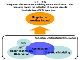
“RADAR” for short Kevin Kloesel kkloesel@gcn.ou.edu Reviewing Algorithms, Definitions, And Resources
You have access to more than one radar for a reason!
Radar “sees” precipitation Spotters observe cloud structures Environmental Shear Vector
Outline for this afternoon: Precipitation Structure* (The Radar stuff: Kevin & Jim) Cloud Structure (The Storm Spotter Stuff: NWS) * And some non-precipitating too!
Cloud Structure? or Precip Structure? • VIPIR • Double low level locks • Shear markers • MOAR • Edge • Advantage • WARN • Double/Super/Mega/ Doppler • Doppler (insert large numbers and letters here) Graphics courtesy of lots of friends with tv sets!
Why spotter? Two sessions for a reason: Attempt to identify precursors to hazards, or the hazards themselves. Attempt to identify precursors to hazards, and then the hazards themselves. Why radar?
Spotter? Two sessions for a reason: What can spotters provide that radar has trouble with? Cloud Structure, particularly in precip-free areas What can radar provide that spotters have trouble with? Seeing through areas of precipitation. Radar?
Base versus Derived Base is raw, Derived has human intervention
1: 3:30 pm, 4 W Thomas 2: 3:30 pm, 4 NNE Custer City 3: No time, WNW from 3 WSW Thomas 4: 3:25-3:30 pm, WNW from Thomas 5: No time, N of Custer City 6: 3:30 pm, 4 NW Thomas 7: No time, ENE from 2 NE Custer City 8: about 3:35 pm, N of Custer City 9: No time, brief N of Custer City 10: No time, N of Custer City 11: No time, N/NW from 2 NE Custer City 12: Before 3:36 pm, 5 WSW Thomas Graphic, reports courtesy of Doug Speheger, NWS Photo by Putnam Reiter
We have LOTS of work to do! Meteorologists: Need to improve algorithms to help identify reflectivity and velocity pattern ID Spotters: Need to improve cloud description techniques and accurate reporting
Radar Strategies for Pro-Active Spotter Deployment BEFORE: Look for boundaries (thin lines)! DURING: Look for the highest reflectivity regions in both base and composite reflectivity data. Look for tight base reflectivity gradients on the lowest elevation scan – usually on south or southeast side of storm (inflow side) Look for familiar patterns (bows, hooks, lines, BWERS, etc.)
High reflectivity values Tight Reflectivity gradients
THE DOPPLER DILEMMA Pulse rates can be set to acquire highly accurate velocity data, OR highly accurate reflectivity data. Although both are sensed simultaneously, there is a trade-off!
WSR-88D Radial Velocity Radar site Reds = outbound motions Greens = inbound motions Brighter colors = higher speeds Cannot “see” motions perpendicular to beam
Radial Velocity Signatures CYCLONIC ROTATION CONVERGENCE DIVERGENCE ANTICYCLONIC ROTATION
Base Velocity vs Storm Relative Velocity • During some events, it may be beneficial to look at BOTH products • Use ___________ for estimating the speed of wind gusts near the surface for straight line winds • Use ___________ for identifying circulation features or convergence/divergence in or near thunderstorms Base Velocity Storm Relative Velocity
1 2 3 4 5
3400 Feet AGL 8000’ 21,000’ 12,000’
3400 Feet AGL 8000’ 21,000’ 12,000’
3800 Feet AGL 9000’ 23,000’ 12,000’
3800 Feet AGL 9000’ 12,000’ 23,000’
Composite Reflectivity 50 For this grid box, the composite reflectivity would display……. 25 50 30
Radar Algorithms • Computer programs to assist in storm analysis • Hail size estimation, mesocyclone/ tornado detection, rainfall estimation • Based on 3-D precipitation structure, empirical and mathematical correlations AND NOT CLOUD STRUCTURE! • ALGORITHMS ARE TOOLS, NOT GOSPEL!
Dangers of “Pathcasting” • Exact arrival times used by television (and some NWS) forecasters • Radar does not allow the level of precision implied by detailed forecasts • Be Careful!!!