Download
1 / 14
140 likes | 332 Views
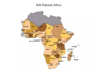
Sub-Saharan Africa: The Land. Landforms: Plateaus, Highlands, and Mountains. SSA (Sub-Saharan Africa) is made up many plateaus. They rise in elevation from the coast inland, and from west to east. The edges of these plateaus are marker by escarpments Steep, often jagged slopes or cliffs.

E N D
Landforms: Plateaus, Highlands, and Mountains • SSA (Sub-Saharan Africa) is made up many plateaus. • They rise in elevation from the coast inland, and from west to east. • The edges of these plateaus are marker by escarpments • Steep, often jagged slopes or cliffs. • Rivers crossing plateaus dropped down the escarpments in cataracts. • Large water-falls • SSA has relatively few mountains • Most African mountains dot the Eastern Highlands • Include Mt. Kilimanjaro and Mt. Kenya • Ruwenzori Mountains • Located West of the Eastern Highlands • Divides Uganda and the Democratic Republic of the Congo. • Covered in snow and cloaked in clouds, its also called the “Mountains of the Moon”
Victoria Falls, Zambia • http://www.smh.com.au/travel/one-metre-from-death-a-dip-in-the-worlds-most-spectacular-pool-20111215-1ovtf.html
“Mountains of the Moon” – The Ruwenzori Mountains • http://www.unesco.org/archives/multimedia/?s=films_details&id_page=33&id_film=1472
The Land: The Great Rift Valley • Stretches from Syria in Southwest Asia to Mozambique. • Rift Valley – a large crack in the earth’s surface formed by shifting tectonic plates • Formed million of years ago, as plate movements created the system of faults or fractures in the earth’s crust. • The Great Rift Valley lays in these faults • Two Branches: • 1. Volcanic Mountains on its edges • 2. Deep lakes that run parallel to its length
Great Rift Valley • http://www.sciencechannel.com/tv-shows/when-earth-erupts/videos/african-rift.htm • Video 2 & 3
Water Systems: Land of Lakes • Most of the Regions lakes are located near the Great Rift Valley • Lake Victoria – Africa’s largest lake, lies between the eastern and western branches of the Rift • Lake Volta: • One of the largest man-made lakes • Created in the 1960s by damming the Volta River south of Ajena, Ghana • Supplies Ghana with irrigation water, electricity, and fishing.
Water Systems: River Basins • Niger River • Means “Great River” • Important for agricultural, transportation, and tourism. • At Aboh in southern Nigeria the river splits into a giant delta, measuring 150 miles long and 200 miles wide (at its broadest). • Delta - a triangular tract of sediment deposited at the mouth of a river, typically where it diverges into several outlets.
Environmental Concerns: Niger Delta • http://www.theguardian.com/global-development/video/2013/oct/16/illegal-oil-refinery-niger-delta-video
Water Systems: The Congo River • Facts: • 2,900 miles long • Largest network of navigable waterways in Africa • Has great and dangerous rapids • Plunges more than 900 feet in numerous cataracts not far from where it reaches the Atlantic Ocean • Meets the Atlantic Ocean through a deep estuary • Estuary - a partially enclosed body of water along the coast where freshwater from rivers and streams meets and mixes with salt water from the ocean.
http://www.fastcompany.com/3020118/work-smart/what-surviving-congo-river-rapids-teaches-us-about-being-tenacioushttp://www.fastcompany.com/3020118/work-smart/what-surviving-congo-river-rapids-teaches-us-about-being-tenacious
Natural Resources • Oil Reserves • Angola, Nigeria, Gabon, Congo • Gold • South Africa provides half the worlds gold • Precious Metals • Zimbabwe, Democratic Republic of the Congo, Tanzania, Ghana • Uranium • Usually found with gold • South Africa, Niger, Gabon, DR Congo, and Namibia • Diamonds • Major: South Africa, Botswana, Congo River basin • Minor: Angola, DR Congo, and Sierra Leone
Africa’s Diamond Trade • http://www.history.com/videos/africas-blood-diamond#africas-blood-diamond