Download
1 / 12
120 likes | 198 Views
Local GI data infrastructure and data broker system development in county Somogy. László Bakos bakos.laszlo@hungarocad.hu. GSDI 6 conference Budapest 19 th September 2002. Cadastral raster maps Topographic raster maps Numbers in cadastral survey Vector based map with contour lines

E N D
Local GI data infrastructure and data broker system development in county Somogy László Bakos bakos.laszlo@hungarocad.hu GSDI 6 conference Budapest 19th September 2002
Cadastral raster maps Topographic raster maps Numbers in cadastral survey Vector based map with contour lines Ownership certificates of registry of title deeds Basic topography (public administration borders, hydrography, road network, etc.) Digital terrain model Digital terrain model for exposition Digital terrain model for gradient of percentages Soil profile data Soil area data (physical, chemical, genetical, nitrate sensitivity, agricultural suitability) Input data and it’s providers:Geonet 2000 Ltd. – MTA-TAKI
Close collaboration with MTA TAKI : Data collection system • The system is based on • GPS technology, • Windows CE OS (Pocket PC, Handheld PC, etc.), • Autodesk OnSite View • Vector maps (EOV = Uniform Country-wide Projection system) • Used for collecting various soil data
Local GI data infrastructure system requirements • Local GI data infrastructure system for a demonstration area: Balatonlelle, Balatonszemes, Gamás, Látrány, Somogybabod, Somogytúr, Visz • Integration of raster and vector data • Web based • Unlimited number of users • Easy to learn user interface • OS independent at client side
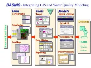
Data flow Publish Autodesk Map 2002 Mapping tool Other applications Data Autodesk MapGuide Server Vector data Database server Raster data Feedback On site measurement results Data collection software Users Authors
Integration of raster maps • Transformation into GeoTiff (geographical raster image) and raster image catalogue • Result: • Autodesk MapGuide displays raster maps under suitable map scale depending on the zoomed map slice
Usage of numbers in cadastral survey • As identifier of records in registry of title deeds database • They appear as digitized data on raster maps on a dedicated layer • They appear automatically if the map scale is less than 10000 m
Soil profile reports • On site descriptions • Data of on site analysis • Data of laboratory analysis • Data of nutritive matereial analysis
Soil area reports • Physical soil area data • Chemical soil area data • Data of nitrate sensitivity • Genetic soil area data • Data of agricultural suitability
Thank you! questions