Download
1 / 19
190 likes | 352 Views
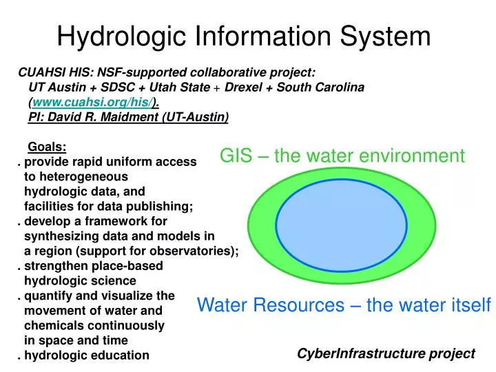
GIS – the water environment. Water Resources – the water itself. Hydrologic Information System. CUAHSI HIS: NSF-supported collaborative project: UT Austin + SDSC + Utah State + Drexel + South Carolina ( www.cuahsi.org/his / ). PI: David R. Maidment (UT-Austin) Goals:

E N D
GIS – the water environment Water Resources – the water itself Hydrologic Information System CUAHSI HIS: NSF-supported collaborative project: UT Austin + SDSC + Utah State + Drexel + South Carolina (www.cuahsi.org/his/). PI: David R. Maidment (UT-Austin) Goals: . provide rapid uniform access to heterogeneous hydrologic data, and facilities for data publishing; . develop a framework for synthesizing data and models in a region (support for observatories); . strengthen place-based hydrologic science . quantify and visualize the movement of water and chemicals continuously in space and time . hydrologic education CyberInfrastructure project
Point Observations Information Model http://www.cuahsi.org/his/webservices.html USGS Data Source GetSites Streamflow gages Network GetSiteInfo Neuse River near Clayton, NC Sites GetVariables GetVariableInfo Discharge, stage (Daily or instantaneous) Variables GetValues Values 206 cfs, 13 August 2006 {Value, Time, Qualifier, Offset} • A data source operates an observation network • A network is a set of observation sites • A site is a point location where one or more variables are measured • A variable is a property describing the flow or quality of water • A value is an observation of a variable at a particular time • A qualifier is a symbol that provides additional information about the value • An offset allows specification of measurements at various depths in water
Locations Variable Codes Date Ranges WaterML and WaterOneFlow STORET Data GetSiteInfo GetVariableInfo GetValues Data NAM NWIS WaterML Data WaterOneFlow Web Service Data Repositories Client EXTRACT TRANSFORM LOAD WaterML is an XML language for communicating water data WaterOneFlow is a set of web services based on WaterML
Set of query functions Returns data in WaterML WaterOneFlow NWIS Daily Values (discharge), NWIS Ground Water, NWIS Unit Values (real time), NWIS Instantaneous Irregular Data, EPA STORET, NCDC ASOS, DAYMET, MODIS, NAM12K, ODM (multiple sites)
Observation Stations Map for the US Ameriflux Towers (NASA & DOE) NOAA Automated Surface Observing System USGS National Water Information System NOAA Climate Reference Network http://river.sdsc.edu/DASH
Global data National data State data Project in region …. Principal investigator data Multiscale Information System
WATERS Network Information System Utah State University HIS Servers National HIS Server at San Diego SuperComputer Center Texas A&M Corpus Christi NSF has funded work at 11 testbed sites, each with its own science agenda. A CUAHSI Hydrologic Information Server is installed at each site.
Corpus Christi Bay WATERS Testbed site National Datasets (National HIS) Regional Datasets (Testbed HIS) USGS NCDC TCOON Dr. Paul Montagna TCEQ SERF NCDC station TCOON stations TCEQ stations Hypoxic Regions Montagna stations USGS gages SERF stations
Supports data discovery, delivery and publication Data discovery – how do I find the data I want? Map interface and observations catalogs Metadata based Search Data delivery – how do I acquire the data I want? Use web services or retrieve from local database Data Publication – how do I publish my observation data? Use Observations Data Model Hydrologic Information Server
GetSites GetSiteInfo GetVariables GetVariableInfo GetValues Hydrologic Information Server WaterOneFlow services DASH – data access system for hydrology ArcGISServer Geospatial Data Observations Data & Catalogs Microsoft SQLServer Relational Database
6 5 4 2 3 1 WORKGROUP HIS SERVER ORGANIZATION STEPS FOR REGISTERING OBSERVATION DATA DASH Web Application Web Configuration file Stores information about registered networks MXD Stores information about layers Layer info,symbology, etc. WSDLs, web service URLs Connectionstrings Spatial store WOF services NWIS-IID points NWIS-IID WS USGS SQL Server NWIS-DV points NWIS-DV WS NWIS-IID NCDC ASOS points ASOS WS NWIS-DV STORET points STORET WS ASOS EPA TCEQ points TCEQ WS STORET BearRiver points BearRiver WS TCEQ TCEQ . . . . . . More WS fromODM-WS template More synced layers BearRiver My new points My new WS . . . More databases Background layers(can be in the same or separate spatial store) Geodatabase or collection of shapefilesor both Web services from a common template My new ODM ODMs and catalogs. All instances exposed as ODM (i.e. have standard ODM tables or views: Sites, Variables, SeriesCatalog, etc.) ODMDataLoader
Syntactic mediation Heterogeneity of format Use WaterML to get data into the same format Semantic mediation Heterogeneity of meaning Each water data source uses its own vocabulary Match these up with a common controlled vocabulary Make standard scientific data queries and have these automatically translated into specific queries on each data source Data Heterogeneity
request return return request NAWQA request return return request NAM-12 request return NWIS request return request return return request NARR Objective • Search multiple heterogeneous data sources simultaneously regardless of semantic or structural differences between them What we are doing now ….. Michael Piasecki Drexel University
NAWQA NWIS NARR HODM Semantic Mediator What we would like to do ….. GetValues GetValues GetValues GetValues generic request GetValues GetValues Michael Piasecki Drexel University GetValues GetValues
HydroseekDemo HydroSeek: http://www.hydroseek.org
TaggerDemo What’s coming • Integrated real time data management • SDL (Utah State) • DataTurbine (SDSC) • Creating a community vocabulary for parameters, and tagging your variables • More agency data sources • Analysis of catalogs: towards spatial history of hydrologic observations • Standards compliance • A flexible modeling framework • Integration with gridded data, and with other CI projects: LTER, GEON, NEON, etc. • Towards digital watershed management
UCSD-DASHDemo RBNB DataTurbine (Ring Buffered Network Bus) • Scalable, secure, programmable, versatile for different data types and vendor interfaces,developer community, with many applications written (e.g. data viewers and plug-ins), open source, high performancestreaming (10mb/s, 1000 frames/s) • Typical scenarios: CS loggers DBMS Loggernet CS loggers Monitoring and management apps NI loggers Other proprietary or in-house
Work with us • Building a larger network of hydrologic data servers • Install a HIS server at your site • Contribute data and services • Join development team • Create hydrologic mashups • Provide feedback • Web sites: • www.cuahsi.org/his/ project info, downloadable software, manuals, workbook • river.sdsc.edu/wiki/ developer notes, issues/bugs tracking, CVS instructions, etc.